Taxon Details
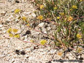
Ivesia campestris
field ivesia
View Report Copy Link Calflora eFlora CCH CalPhotos iNaturalist
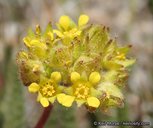
© 2020 Keir Morse |

© 2020 Keir Morse |
© 2020 Keir Morse |
Taxon Summary:
Ivesia campestris, commonly known as field ivesia, is a perennial herb in the Rosaceae that is found only in California. It occurs within Meadows and seeps (edges), Subalpine coniferous forest, and Upper montane coniferous forest, growing at elevations from 1975 to 3395 meters. Ivesia campestris is ranked 1B.2, Plants Rare, Threatened or Endangered in California and Elsewhere; Moderately threatened in California.|
Scientific Name: Ivesia campestris (Jones) Rydb. |
||
|
Common Name: field ivesia |
||
| Family: | Rosaceae | |
| Element Code: | PDROS0X050 | |
| USDA Plants Symbol: | IVCA2 | |
|
Synonyms/Other Names: |
||
| Name Status: |
JEF, FNA, POWO, IPNI, Tropicos |
|
| CA Rare Plant Rank: | 1B.2 |
| Fed List: | None |
| State List: | None |
| Global Rank: | G3 |
|
State Rank: |
S3 |
| Other Status: | SB_CalBG/RSABG |
|
CRPR Changes: |
|
| Add Date: | 1974-01-01 |
| Date Edited: | 2025-10-29 |
| Lifeform: perennial herb | ||||||||||||||
Blooming Period: May-Aug
|
||||||||||||||
|
Elevation:
1975 - 3395 meters 6480 - 11140 feet |
||||||||||||||
General Habitats:
|
||||||||||||||
| Microhabitat Details: | ||||||||||||||
|
Microhabitat:
|
||||||||||||||
| Threat List Total: | 5 | |
| Total EOs | % of EOs | |
| EOs with Threat Listed: | 23 | 33 % |
| THREAT LIST: | ||
|---|---|---|
| Grazing | 20 | 28% |
| Foot traffic/trampling | 13 | 18% |
| Recreational use (non-ORV) | 12 | 17% |
| ORV activity | 3 | 4% |
| Road/trail construction/maint. | 2 | 2% |
| Total Occurrences: | 69 | ||||
| Element Occurrence Ranks: | |||||
|---|---|---|---|---|---|
| A | B | C | D | X | U |
| 8 | 13 | 4 | 0 | 0 | 44 |
| Occurrence Status: | |||||
|---|---|---|---|---|---|
| Historical >20 Years | 48 | ||||
| Recent <=20 Years | 21 | ||||
| Presence: | |||||
|---|---|---|---|---|---|
| Presumed Extant | 69 | ||||
| Possibly Extirpated | 0 | ||||
| Presumed Extirpated | 0 | ||||
| California Endemic: | |||||||||||||
| California Island: | |||||||||||||
|
States: Name (Code) California (CA) |
|||||||||||||
|
California Counties and Islands: Name (Code) Fresno (FRE), Inyo (INY), Tulare (TUL) |
|||||||||||||
|
Quads: Name (Quad Code) Camp Nelson (3611825), Cannell Peak (3511873), Casa Vieja Meadows (3611823), Chagoopa Falls (3611844), Cirque Peak (3611842), Crag Peak (3611812), General Grant Grove (3611868), Haiwee Pass (3611821), Hume (3611878), Johnson Peak (3611843), Kern Lake (3611834), Kern Peak (3611833), Mineral King (3611845), Monache Mountain (3611822), Moses Mtn. (3611836), Mount Whitney (3611853), Mt. Langley (3611852), Mt. Silliman (3611866), Muir Grove (3611867), Quinn Peak (3611835), Silver City (3611846), Sirretta Peak (3511883), Slide Bluffs (3611886), Templeton Mtn. (3611832) |
|||||||||||||
Notes:
|
|||||||||||||
 Presumed Extant
Click on quad for name. Hold Shift Key to use mouse scroll wheel