Taxon Details
Abronia villosa var. aurita
chaparral sand-verbena
View Report Copy Link Calflora eFlora CCH CalPhotos iNaturalist
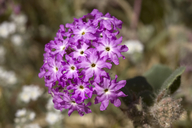
© 2011 Aaron E. Sims |

© 2011 Aaron E. Sims |
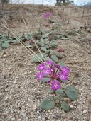
© 2011 Duncan S. Bell |
Taxon Summary:
Abronia villosa var. aurita, commonly known as chaparral sand-verbena, is a annual herb in the Nyctaginaceae that is found in California and elsewhere. It occurs within Chaparral, Coastal scrub, and Desert dunes, growing at elevations from 75 to 1600 meters. Abronia villosa var. aurita is ranked 1B.1, Plants Rare, Threatened or Endangered in California and Elsewhere; Seriously threatened in California.|
Scientific Name: Abronia villosa Wats. var. aurita (Abrams) Jeps. |
||
|
Common Name: chaparral sand-verbena |
||
| Family: | Nyctaginaceae | |
| Element Code: | PDNYC010P1 | |
| USDA Plants Symbol: | ABVIA | |
|
Synonyms/Other Names: |
||
| Name Status: |
JEF, FNA, POWO, IPNI, Tropicos |
|
| CA Rare Plant Rank: | 1B.1 |
| Fed List: | None |
| State List: | None |
| Global Rank: | G5T2? |
|
State Rank: |
S2 |
| Other Status: | BLM_S; SB_CalBG/RSABG; USFS_S |
|
CRPR Changes: |
|
| Add Date: | 2001-01-01 |
| Date Edited: | 2025-10-29 |
| Lifeform: annual herb | ||||||||||||||
Blooming Period: (Jan)Mar-Sep
|
||||||||||||||
|
Elevation:
75 - 1600 meters 245 - 5250 feet |
||||||||||||||
General Habitats:
|
||||||||||||||
| Microhabitat Details: | ||||||||||||||
Microhabitat:
|
||||||||||||||
| Threat List Total: | 16 | |
| Total EOs | % of EOs | |
| EOs with Threat Listed: | 41 | 42 % |
| THREAT LIST: | ||
|---|---|---|
| Development | 17 | 17% |
| ORV activity | 13 | 13% |
| Altered flood/tidal/hydrologic regime | 8 | 8% |
| Biocides | 5 | 5% |
| Channelization | 5 | 5% |
| Road/trail construction/maint. | 5 | 5% |
| Vandalism/dumping/litter | 4 | 4% |
| Other | 4 | 4% |
| Non-native plant impacts | 4 | 4% |
| Agriculture | 3 | 3% |
| Recreational use (non-ORV) | 2 | 2% |
| Foot traffic/trampling | 2 | 2% |
| Grazing | 2 | 2% |
| Improper burning regime | 2 | 2% |
| Disking | 1 | 1% |
| Dam/Inundation | 1 | 1% |
| Total Occurrences: | 98 | ||||
| Element Occurrence Ranks: | |||||
|---|---|---|---|---|---|
| A | B | C | D | X | U |
| 0 | 7 | 9 | 8 | 7 | 67 |
| Occurrence Status: | |||||
|---|---|---|---|---|---|
| Historical >20 Years | 54 | ||||
| Recent <=20 Years | 44 | ||||
| Presence: | |||||
|---|---|---|---|---|---|
| Presumed Extant | 91 | ||||
| Possibly Extirpated | 1 | ||||
| Presumed Extirpated | 6 | ||||
| California Endemic: | |||||||||||||
| California Island: | |||||||||||||
|
States: Name (Code) Arizona (AZ), Baja California (BA), California (CA) |
|||||||||||||
|
California Counties and Islands: Name (Code) Imperial (IMP), Orange (ORA)*, Riverside (RIV), San Bernardino (SBD), San Diego (SDG) |
|||||||||||||
|
Quads: Name (Quad Code) Agua Caliente Springs (3211683), Aguanga (3311647), Alberhill (3311764), Anaheim (3311778)*, Anza (3311656), Bachelor Mtn. (3311751), Barstow (3411781), Beaumont (3311688), Black Star Canyon (3311776), Blackburn Canyon (3311667), Borrego Palm Canyon (3311634), Bucksnort Mtn. (3311645), Butterfly Peak (3311655), Cabazon (3311687), Calexico (3211564), Cathedral City (3311674), Collins Valley (3311644), Corona North (3311785), Corona South (3311775), Durmid (3311547), Earthquake Valley (3311614), East Deception Canyon (3311683), East of Victory Pass (3311573), Fallbrook (3311743), Heber (3211565), Hemet (3311668), Idyllwild (3311666), Indio (3311662), La Quinta (3311663), Lake Fulmor (3311677), Lake Mathews (3311774), Lakeview (3311771), Morro Hill (3311733), Mortmar (3311558), Murrieta (3311752), Myoma (3311673), Newport Beach (3311768)*, Orange (3311777)*, Palm Springs (3311675), Palm View Peak (3311665), Pechanga (3311741), Perris (3311772), Prado Dam (3311786), Ranchita (3311625), Sage (3311658), Salton (3311548), San Jacinto (3311678), Seeley (3211576), Temecula (3311742), Thermal Canyon (3311661), Tubb Canyon (3311624), Vail Lake (3311648), Valerie (3311652), White Water (3311686), Winchester (3311761) |
|||||||||||||
Notes:
|
|||||||||||||
 Presumed Extant
Click on quad for name. Hold Shift Key to use mouse scroll wheel