Taxon Details
Diplacus pictus
calico monkeyflower
View Report Copy Link Calflora eFlora CCH CalPhotos iNaturalist
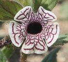
© 2020 Matt C. Berger |

© 2019 Spencer Riffle |
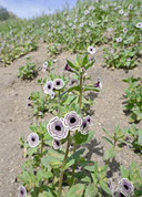
© 2019 Neal Kramer |
Taxon Summary:
Diplacus pictus, commonly known as calico monkeyflower, is a annual herb in the Phrymaceae that is found only in California. It occurs within Broadleafed upland forest, and Cismontane woodland, growing at elevations from 100 to 1430 meters. Diplacus pictus is ranked 1B.2, Plants Rare, Threatened or Endangered in California and Elsewhere; Moderately threatened in California.|
Scientific Name: Diplacus pictus (Curran ex Greene) G.L. Nesom |
||
|
Common Name: calico monkeyflower |
||
| Family: | Phrymaceae | |
| Element Code: | PDSCR1B240 | |
| USDA Plants Symbol: | ||
|
Synonyms/Other Names: |
||
| Name Status: |
JEF, FNA, POWO, IPNI, Tropicos |
|
| CA Rare Plant Rank: | 1B.2 |
| Fed List: | None |
| State List: | None |
| Global Rank: | G2 |
|
State Rank: |
S2 |
| Other Status: | BLM_S; SB_CalBG/RSABG |
|
CRPR Changes: |
|
| Add Date: | 1974-01-01 |
| Date Edited: | 2025-10-29 |
| Lifeform: annual herb | ||||||||||||||
Blooming Period: Mar-May
|
||||||||||||||
|
Elevation:
100 - 1430 meters 330 - 4690 feet |
||||||||||||||
General Habitats:
|
||||||||||||||
| Microhabitat Details: | ||||||||||||||
Microhabitat:
|
||||||||||||||
| Threat List Total: | 8 | |
| Total EOs | % of EOs | |
| EOs with Threat Listed: | 17 | 23 % |
| THREAT LIST: | ||
|---|---|---|
| Grazing | 9 | 12% |
| Non-native plant impacts | 4 | 5% |
| Other | 3 | 4% |
| Road/trail construction/maint. | 3 | 4% |
| Foot traffic/trampling | 2 | 2% |
| Mining | 1 | 1% |
| Dam/Inundation | 1 | 1% |
| Erosion/runoff | 1 | 1% |
| Total Occurrences: | 73 | ||||
| Element Occurrence Ranks: | |||||
|---|---|---|---|---|---|
| A | B | C | D | X | U |
| 4 | 25 | 6 | 1 | 0 | 37 |
| Occurrence Status: | |||||
|---|---|---|---|---|---|
| Historical >20 Years | 35 | ||||
| Recent <=20 Years | 38 | ||||
| Presence: | |||||
|---|---|---|---|---|---|
| Presumed Extant | 73 | ||||
| Possibly Extirpated | 0 | ||||
| Presumed Extirpated | 0 | ||||
| California Endemic: | |||||||||||||
| California Island: | |||||||||||||
|
States: Name (Code) California (CA) |
|||||||||||||
|
California Counties and Islands: Name (Code) Kern (KRN), Tulare (TUL) |
|||||||||||||
|
Quads: Name (Quad Code) Arvin (3511827), Bear Mountain (3511826), Bena (3511836), Chickencoop Canyon (3611838), Cummings Mtn. (3511815), Democrat Hot Springs (3511856), Frazier Valley (3611828), Glennville (3511866), Grapevine (3411888), Keene (3511825), Lebec (3411877), Lindsay (3611921), Loraine (3511834), Miracle Hot Springs (3511855), Mt. Adelaide (3511846), Oil Center (3511848), Oiler Peak (3511835), Onyx (3511862), Pastoria Creek (3411887), Pine Mountain (3511857), Quincy School (3511878), Rio Bravo Ranch (3511847), Rocky Hill (3611931), Sand Canyon (3511868), Success Dam (3611818), Tehachapi NE (3511823), Tehachapi North (3511824), Tehachapi South (3511814), Tejon Hills (3511817), Tejon Ranch (3511816), Weldon (3511863), White River (3511877), Winters Ridge (3411886), Woody (3511867) |
|||||||||||||
Notes:
|
|||||||||||||
 Presumed Extant
Click on quad for name. Hold Shift Key to use mouse scroll wheel