Taxon Report
Botrychium minganense VictorinMingan moonwort |
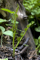
 © 2011 Aaron E. Sims |
Taxon Summary
Botrychium minganense, commonly known as Mingan moonwort, is a perennial rhizomatous herb in the Ophioglossaceae that is found in California and elsewhere. It occurs within Bogs and fens, Lower montane coniferous forest, Meadows and seeps (edges), and Upper montane coniferous forest, growing at elevations from 1190 to 3290 meters. Botrychium minganense is ranked 4.2, Plants of Limited Distribution, A Watch List; Moderately threatened in California.Classification
|
Scientific Name: |
Botrychium minganense Victorin |
|
Common Name: |
Mingan moonwort |
| Family: | Ophioglossaceae |
| Element Code: | PPOPH010R0 |
| USDA Plants Symbol: | BOMI |
|
Synonyms/Other Names: |
|
Ecology and Life History
| Lifeform: | perennial rhizomatous herb |
| Blooming Period: Jul-Sep(Oct) | Jul-Sep(Oct) |
| Elevation: | 1190-3290 (3905-10795) |
| General Habitats: | Bogs and fens, Lower montane coniferous forest, Meadows and seeps, Upper montane coniferous forest |
| Microhabitat: | Mesic |
| Microhabitat Details: | Frequently co-occurs with B. ascendens, B. crenulatum or B. montanum |
Conservation Status
| CA Rare Plant Rank: | 4.2 |
| Global Rank: | G5 |
|
State Rank: |
S4 |
| State List: | None |
| Fed List: | None |
| Other Status: | USFS_S |
|
CRPR Changes: |
|
Occurrence Data from the CNDDB
| Total Occurrences: | 161 |
| Element Occurrence Ranks: | |
| Excellent (A) | 11 |
| Good (B) | 48 |
| Fair (C) | 22 |
| Poor (D) | 11 |
| None (X) | 1 |
| Unknown (U) | 68 |
| California Endemic: False | |
| California Counties and Islands: Name (Code) | |
| Amador (AMA), Butte (BUT), Calaveras (CAL), El Dorado (ELD), Fresno (FRE), Lassen (LAS), Madera (MAD), Modoc (MOD), Mono (MNO), Nevada (NEV), Placer (PLA), Plumas (PLU), Shasta (SHA), Sierra (SIE), Siskiyou (SIS), Tehama (TEH), Trinity (TRI), Tulare (TUL), Tuolumne (TUO) | |
| Quads: Name (Quad Code) | |
| American House (3912161), Antelope Mtn. (4012058), Barkley Mtn. (4012126), Bear River Reservoir (3812052), Belden (4012113), Blairsden (3912075), Boards Crossing (3812032), Bunker Hill (3912014), Butte Meadows (4012115), Calaveras Dome (3812042), Canyondam (4012121), Caples Lake (3812061), Cascade (3912162), Cherry Lake North (3811918), Convict Lake (3711857), Crocker Mtn. (3912084), Diamond Mtn. (4012036), Dorrington (3812033), Duncan Peak (3912025), Dunderberg Peak (3811913), Emerald Bay (3812081), Emigrant Lake (3811926), Fredonyer Pass (4012037), Grays Peak (4012146), Grizzly Valley (3912085), Hatchet Mtn. Pass (4012177), Haypress Valley (3912055), Hobart Mills (3912042), Hull Creek (3812011), Humboldt Peak (4012124), Humbug Valley (4012123), Independence Lake (3912043), Jonesville (4012114), Kaiser Peak (3711932), Kimshew Point (3912184), Kyburz (3812073), La Porte (3912068), Lassen Peak (4012145), Leek Spring Hill (3812063), Liberty Hill (3812031), Little Shuteye Peak (3711944), Lodgepole (3611856), Loon Lake (3812083), Lyonsville (4012136), Martis Peak (3912031), Meeks Bay (3912011), Miller Mtn. (4012167), Mineral (4012135), Moses Mtn. (3611836), Mt. Harkness (4012143), Mt. Silliman (3611866), Mumbo Basin (4112225), Norden (3912033), North Palisade (3711815), Onion Valley (3912078), Peddler Hill (3812053), Pegleg Mtn. (4012048), Red Cinder (4012142), Riverton (3812074), Robbs Peak (3812084), Roop Mountain (4012047), Sattley (3912054), Seven Lakes Basin (4112224), Shields Creek (4112043), Silver City (3611846), Skunk Ridge (4112117), Soapstone Hill (3912173), South Lake Tahoe (3811988), Sphinx Lakes (3611865), Swain Mountain (4012141), Tahoe City (3912022), Tamarack (3812041), Tangle Blue Lake (4112226), Templeton Mtn. (3611832), Tioga Pass (3711983), Tragedy Spring (3812062), Triple Divide Peak (3611855), Viola (4012156), Wentworth Springs (3912013), West Haight Mtn. (4112251), Westwood East (4012038), Westwood West (4012131), Ycatapom Peak (4112217) | |
Threat List Data from the CNDDB
| Threat List Total: | 14 | |
| EOs with Threat Listed: | Total EOs | % of EOs |
| 93 | 58 % | |
| Logging | 43 | 26% |
| Grazing | 28 | 17% |
| Foot traffic/trampling | 20 | 12% |
| Other | 15 | 9% |
| Road/trail construction/maint. | 10 | 6% |
| Wood cutting or brush clearing | 6 | 3% |
| Altered flood/tidal/hydrologic regime | 6 | 3% |
| Improper burning regime | 5 | 3% |
| Surface water diversion | 3 | 1% |
| Recreational use (non-ORV) | 3 | 1% |
| Non-native plant impacts | 3 | 1% |
| ORV activity | 3 | 1% |
| Groundwater pumping | 1 | 0% |
| Vandalism/dumping/litter | 1 | 0% |
Notes
|
Threats: |
| Threatened by logging and related activities, livestock grazing and trampling, hydrologic changes, water diversions, habitat loss, road and utility line maintenance, recreational activities and foot traffic, off-road vehicles, wildfire and fuel reduction projects, non-native plants, disturbance associated with riparian or meadow enhancement. Possibly threatened by alteration of fire regimes and extirpation due to small population size. |
|
Taxonomy: |
| Evidently an allotetraploid species (n = 90) from a cross between B. neolunaria and B. “farrarii” ined. (both diploids with n = 45). Similar to B. crenulatum which is more delicate, has fewer pinna pairs and a diploid chromosome number (n = 45). |
Selected References
| Proposed Change from CRPR 2B.2, G5 / S3 to 4.2, G5 / S4 |
| Proceedings and Transactions of the Royal Society of Canada, sér. 3, 21: 331 (1927) |
| Botrychium minganense account for potential Species of Conservation Concern evaluation (2023) |
| Molecular Phylogenetics and Evolution 120: 342–353 (2018) |
Citation
California Native Plant Society, Rare Plant Program. 2026. Rare Plant Inventory (online edition, v9.5.1). Website https://www.rareplants.cnps.org [accessed 23 February 2026].