Species Details
Androstephium breviflorum
small-flowered androstephium
Download Report Calflora eFlora CCH CalPhotos
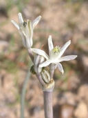
© 2005 James M. Andre |

© 2010 Chris Winchell |

© 2015 Lorah Patterson |
|
Scientific Name: Androstephium breviflorum Wats. |
||
|
Common Name: small-flowered androstephium |
||
| Family: | Themidaceae | |
| Element Code: | PMLIL06010 | |
| USDA Plants Symbol: | ANBR4 | |
|
Synonyms/Other Names: |
||
| CA Rare Plant Rank: | 2B.2 |
| Fed List: | None |
| State List: | None |
| Global Rank: | G5 |
|
State Rank: |
S2? |
| Other Status: | |
|
CRPR Changes: changed from 2.2 to 2B.2 on 2013-06-12 changed from 2.3 to 2.2 on 2009-03-10 |
|
| Add Date: | 1974-01-01 |
| Date Edited: | 2022-08-02 |
| Lifeform: perennial bulbiferous herb | ||||||||||||||
Blooming Period: Mar-Apr
|
||||||||||||||
|
Elevation:
220 - 800 meters 720 - 2625 feet |
||||||||||||||
General Habitats:
|
||||||||||||||
| Microhabitat Details: | ||||||||||||||
|
Microhabitat:
|
||||||||||||||
| Threat List Total: | 8 | |
| Total EOs | % of EOs | |
| EOs with Threat Listed: | 97 | 79 % |
| THREAT LIST: | ||
|---|---|---|
| Development | 67 | 54% |
| ORV activity | 16 | 13% |
| Non-native plant impacts | 15 | 12% |
| Road/trail construction/maint. | 8 | 6% |
| Military operations | 7 | 5% |
| Other | 5 | 4% |
| Recreational use (non-ORV) | 1 | 0% |
| Vandalism/dumping/litter | 1 | 0% |
| Total Occurrences: | 123 | ||||
| Element Occurrence Ranks: | |||||
|---|---|---|---|---|---|
| A | B | C | D | X | U |
| 0 | 15 | 26 | 47 | 0 | 35 |
| Occurrence Status: | |||||
|---|---|---|---|---|---|
| Historical >20 Years | 18 | ||||
| Recent <=20 Years | 105 | ||||
| Presence: | |||||
|---|---|---|---|---|---|
| Presumed Extant | 123 | ||||
| Possibly Extirpated | 0 | ||||
| Presumed Extirpated | 0 | ||||
| California Endemic: | |||||||||||||
| California Island: | |||||||||||||
|
States: Name (Code) Arizona (AZ), California (CA), Colorado (CO), Nevada (NV), New Mexico (NM), Utah (UT), Wyoming (WY) |
|||||||||||||
|
California Counties and Islands: Name (Code) Inyo (INY), Riverside (RIV), San Bernardino (SBD) |
|||||||||||||
|
Quads: Name (Quad Code) Amboy (3411556), Amboy Crater (3411557), Arica Mountains (3411418), Avawatz Pass (3511654), Baker (3511631), Broadwell Mesa (3411681), Cadiz Lake (3411534), Cadiz Valley SE (3411513), Calvada Springs (3511588), Cave Mountain (3511613), Chubbuck (3411533), Cowhole Mountain (3511518), Dumont Dunes (3511662), Dunn (3511614), Gene Wash (3411432), Grommet (3411416), Hector (3411674), Hidden Valley East (3411683), Ivanpah Lake (3511554), Mound Spring (3611518), North of Baker (3511641), North of Tecopa Pass (3511681), Pinto Wells (3311584), Red Pass Lake (3511633), Red Pass Lake Ne (3511643), Red Pass Lake Nw (3511644), Rice (3411417), Sheep Creek Spring (3511653), Silurian Lake (3511652), Silurian Valley (3511642), Skeleton Pass (3411553), Sleeping Beauty (3411673), Soda Lake South (3511611), Stump Spring, Nev. (3511587), Sunshine Peak (3411664), Tecopa Pass (3511671), Troy Lake (3411675), Valjean Hills (3511661), West of Baker (3511632) |
|||||||||||||
Notes:
|
|||||||||||||
 Presumed Extant
Click on quad for name. Hold Shift Key to use mouse scroll wheel