Species Details
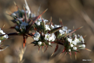
Chorizanthe spinosa
Mojave spineflower
Download Report Calflora eFlora CCH CalPhotos
© 2011 Benjamin Smith |

© 2012 Neal Kramer |
© 2021 Ryan O'Dell |
|
Scientific Name: Chorizanthe spinosa Wats. |
||
|
Common Name: Mojave spineflower |
||
| Family: | Polygonaceae | |
| Element Code: | PDPGN040R0 | |
| USDA Plants Symbol: | CHSP | |
|
Synonyms/Other Names: |
||
| CA Rare Plant Rank: | 4.2 |
| Fed List: | None |
| State List: | None |
| Global Rank: | G4 |
|
State Rank: |
S4 |
| Other Status: | |
|
CRPR Changes: |
|
| Add Date: | 1974-01-01 |
| Date Edited: | 2021-11-05 |
| Lifeform: annual herb | ||||||||||||||
Blooming Period: Mar-Jul
|
||||||||||||||
|
Elevation:
6 - 1300 meters 20 - 4265 feet |
||||||||||||||
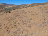
General Habitats:
|
||||||||||||||
| Microhabitat Details: | ||||||||||||||
Microhabitat:
|
||||||||||||||
|
Notes: Threatened by vehicles, road maintenance, development, and illegal dumping. Potentially threatened in Kramer Junction by solar development. See Flora of California 2:481 (1880) by S. Watson for original description, and Phytologia 66(2):109-110 (1989) for taxonomic treatment. |
|
|
Threats: |
|
|
Taxonomy: |
|
| Threat List Total: | 0 | |
| Total EOs | % of EOs | |
| EOs with Threat Listed: | 0 | 0 % |
| THREAT LIST: | ||
|---|---|---|
| Total Occurrences: | 0 | ||||
| Element Occurrence Ranks: | |||||
|---|---|---|---|---|---|
| A | B | C | D | X | U |
| 0 | 0 | 0 | 0 | 0 | 0 |
| Occurrence Status: | |||||
|---|---|---|---|---|---|
| Historical >20 Years | 0 | ||||
| Recent <=20 Years | 0 | ||||
| Presence: | |||||
|---|---|---|---|---|---|
| Presumed Extant | 0 | ||||
| Possibly Extirpated | 0 | ||||
| Presumed Extirpated | 0 | ||||
| California Endemic: | |||||||||||||
| California Island: | |||||||||||||
|
States: Name (Code) California (CA) |
|||||||||||||
|
California Counties and Islands: Name (Code) Kern (KRN), Los Angeles (LAX), San Bernardino (SBD), San Luis Obispo (SLO) |
|||||||||||||
|
Quads: Name (Quad Code) Adelanto (3411754), Astley Rancho (3411774), Barstow (3411781), Barstow SE (3411771), Bissell (3411881), Boron (3511716), Boron Ne (3511725), California City North (3511728), Cantil (3511738), Cinco (3511831), Dove Spring (3511841), Edwards (3411788), Elkhorn Hills (3511915), Galileo Hill (3511727), Garlock (3511747), Hesperia (3411743), Hinkley (3411782), Jackrabbit Hill (3411776), Klinker Mtn. (3511745), Kramer Hills (3411784), Kramer Junction (3411785), La Liebre Ranch (3411876), Lancaster East (3411861), Lancaster West (3411862), Leuhman Ridge (3411786), Little Buttes (3411873), Lockhart (3511713), Lucerne Valley (3411648), Mojave (3511812), Nebo (3411688), North Edwards (3511717), Palmdale (3411851), Red Buttes (3411775), Red Mountain (3511735), Redman (3411778), Rogers Lake North (3411787), Rogers Lake South (3411777), Rosamond (3411872), Rosamond Lake (3411871), Saddleback Mtn. (3511715), Saltdale NW (3511748), Saltdale SE (3511737), Sanborn (3511811), Soledad Mtn. (3411882), The Buttes (3511714), Twelve Gauge Lake (3411783), Water Valley (3511712), Wild Crossing (3411773), Willow Springs (3411883) |
|||||||||||||
Notes:
|
|||||||||||||
 Presumed Extant
Click on quad for name. Hold Shift Key to use mouse scroll wheel