Species Details
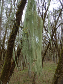
Usnea longissima
Methuselah's beard lichen
Download Report Calflora eFlora CCH CalPhotos
© 2021 Scot Loring |

© 2014 Eric B. Peterson |
© 2015 Adrienne Simmons |
|
Scientific Name: Usnea longissima Ach. |
||
|
Common Name: Methuselah's beard lichen |
||
| Family: | Parmeliaceae | |
| Element Code: | NLLEC5P420 | |
| USDA Plants Symbol: | USLO50 | |
|
Synonyms/Other Names: |
||
| CA Rare Plant Rank: | 4.2 |
| Fed List: | None |
| State List: | None |
| Global Rank: | G4 |
|
State Rank: |
S4 |
| Other Status: | BLM_S |
|
CRPR Changes: changed from 4.3 to 4.2 on 2014-04-08 changed from 4 to 4.3 on 2014-03-21 added to 4 on 2014-03-02 |
|
| Add Date: | 2014-03-01 |
| Date Edited: | 2021-10-08 |
| Lifeform: fruticose lichen (epiphytic) | ||||||||||||||
Blooming Period:
|
||||||||||||||
|
Elevation:
50 - 1460 meters 165 - 4790 feet |
||||||||||||||
General Habitats:
|
||||||||||||||
| Microhabitat Details: On tree branches; usually on old growth hardwoods and conifers | ||||||||||||||
|
Microhabitat:
|
||||||||||||||
| Threat List Total: | 6 | |
| Total EOs | % of EOs | |
| EOs with Threat Listed: | 161 | 78 % |
| THREAT LIST: | ||
|---|---|---|
| Logging | 153 | 74% |
| Other | 27 | 13% |
| Road/trail construction/maint. | 25 | 12% |
| Recreational use (non-ORV) | 2 | 0% |
| Agriculture | 2 | 0% |
| Development | 2 | 0% |
| Total Occurrences: | 206 | ||||
| Element Occurrence Ranks: | |||||
|---|---|---|---|---|---|
| A | B | C | D | X | U |
| 14 | 34 | 57 | 47 | 2 | 52 |
| Occurrence Status: | |||||
|---|---|---|---|---|---|
| Historical >20 Years | 206 | ||||
| Recent <=20 Years | 0 | ||||
| Presence: | |||||
|---|---|---|---|---|---|
| Presumed Extant | 204 | ||||
| Possibly Extirpated | 1 | ||||
| Presumed Extirpated | 1 | ||||
| California Endemic: | |||||||||||||
| California Island: | |||||||||||||
|
States: Name (Code) Alaska (AK), California (CA), Maine (ME), Michigan (MI), Minnesota (MN), Missouri (MO), Montana (MT), New Hampshire (NH), New York (NY), Oregon (OR), Vermont (VT), Washington (WA), Wisconsin (WI) |
|||||||||||||
|
California Counties and Islands: Name (Code) Del Norte (DNT), Humboldt (HUM), Mendocino (MEN), San Mateo (SMT), Santa Cruz (SCR), Sonoma (SON) |
|||||||||||||
|
Quads: Name (Quad Code) Ah Pah Ridge (4112348), Annapolis (3812363), Arcata South (4012471), Bailey Ridge (3912324), Bald Hills (4112328), Bear Harbor (3912388), Big Basin (3712222), Blocksburg (4012336), Blue Lake (4012388), Briceland (4012318), Bridgeville (4012347), Buckeye Mtn. (4012432), Bull Creek (4012431), Camp Meeker (3812248), Cant Hook Mtn. (4112368), Cazadero (3812351), Childs Hill (4112461), Cold Spring (3912315), Comptche (3912335), Crannell (4112411), Duncans Mills (3812341), Dutchmans Knoll (3912356), Elk (3912326), Ettersburg (4012328), Eureka Hill (3812385), Fern Canyon (4112441), Ferndale (4012453), Fort Ross (3812352), Fort Seward (4012326), Fortuna (4012452), Garberville (4012317), Gasquet (4112378), Greenough Ridge (3912334), Gualala (3812375), Guerneville (3812258), Hales Grove (3912377), Harris (4012316), High Divide (4112481), Hiouchi (4112471), Honeydew (4012421), Hydesville (4012451), Iaqua Buttes (4012368), Inglenook (3912357), Korbel (4012378), Leggett (3912376), Lincoln Ridge (3912366), Lord-ellis Summit (4012387), Mad River Buttes (4012367), Mallo Pass Creek (3912316), Maple Creek (4012377), Mathison Peak (3912336), McWhinney Creek (4012461), Mendocino (3912337), Mindego Hill (3712232), Miranda (4012327), Mistake Point (3912378), Myers Flat (4012337), Navarro (3912325), Noble Butte (3912386), Northspur (3912345), Noyo Hill (3912346), Orick (4112431), Ornbaun Valley (3812383), Orrs Springs (3912323), Owl Creek (4012358), Panther Creek (4112318), Philo (3912314), Piercy (3912387), Plantation (3812353), Point Arena (3812386), Redcrest (4012348), Requa (4112451), Scotia (4012441), Shelly Creek Ridge (4112387), Shelter Cove (4012411), Sherwood Peak (3912355), Shubrick Peak (4012422), Smith River (4112482), Stewarts Point (3812364), Taylor Peak (4012442), Weott (4012338), Woodside (3712243), Yager Junction (4012357), Yorkville (3812382) |
|||||||||||||
Notes:
|
|||||||||||||
 Presumed Extant
Click on quad for name. Hold Shift Key to use mouse scroll wheel