Taxon Details
Montia howellii
Howell's montia
View Report Copy Link Calflora eFlora CCH CalPhotos iNaturalist
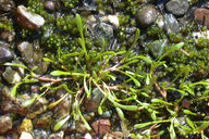
© 2004 Dean Wm. Taylor |
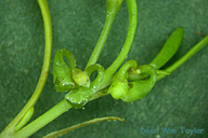
© 2004 Dean Wm. Taylor |
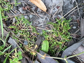
© 2015 Adrienne Simmons |
Taxon Summary:
Montia howellii, commonly known as Howell's montia, is a annual herb in the Montiaceae that is found in California and elsewhere. It occurs within Meadows and seeps, North Coast coniferous forest, and Vernal pools, growing at elevations from 0 to 835 meters. Montia howellii is ranked 2B.2, Plants Rare, Threatened, or Endangered in California, But More Common Elsewhere; Moderately threatened in California.|
Scientific Name: Montia howellii Wats. |
||
|
Common Name: Howell's montia |
||
| Family: | Montiaceae | |
| Element Code: | PDPOR05070 | |
| USDA Plants Symbol: | MOHO | |
|
Synonyms/Other Names: |
||
| Name Status: |
JEF, FNA, POWO, IPNI, Tropicos |
|
| CA Rare Plant Rank: | 2B.2 |
| Fed List: | None |
| State List: | None |
| Global Rank: | G3G4 |
|
State Rank: |
S2 |
| Other Status: | |
|
CRPR Changes: changed from 2B.2 to 2B.2 on 2020-11-19 changed from 2.2 to 2B.2 on 2006-04-17 |
|
| Add Date: | 1994-01-01 |
| Date Edited: | 2025-10-29 |
| Lifeform: annual herb | ||||||||||||||
Blooming Period: (Feb)Mar-May
|
||||||||||||||
|
Elevation:
0 - 835 meters 0 - 2740 feet |
||||||||||||||
General Habitats:
|
||||||||||||||
| Microhabitat Details: | ||||||||||||||
Microhabitat:
|
||||||||||||||
|
Notes: Rediscovered in CA in 1999 by Clare Golec. Did plant occur in DNT Co.? Candidate for state listing in OR. |
|
|
Threats: Threatened by logging, road construction, road maintenance, vehicles, and competition. Possibly threatened by non-native plants. |
|
|
Taxonomy: Sometimes mistaken for M. fontana or M. dichotoma. |
|
| Threat List Total: | 14 | |
| Total EOs | % of EOs | |
| EOs with Threat Listed: | 109 | 89 % |
| THREAT LIST: | ||
|---|---|---|
| Road/trail construction/maint. | 87 | 70% |
| Logging | 79 | 64% |
| Other | 30 | 24% |
| Grazing | 15 | 12% |
| Foot traffic/trampling | 14 | 11% |
| Non-native plant impacts | 12 | 9% |
| ORV activity | 11 | 8% |
| Altered flood/tidal/hydrologic regime | 6 | 4% |
| Surface water diversion | 5 | 4% |
| Wood cutting or brush clearing | 3 | 2% |
| Vandalism/dumping/litter | 2 | 1% |
| Biocides | 2 | 1% |
| Erosion/runoff | 2 | 1% |
| Recreational use (non-ORV) | 2 | 1% |
| Total Occurrences: | 123 | ||||
| Element Occurrence Ranks: | |||||
|---|---|---|---|---|---|
| A | B | C | D | X | U |
| 11 | 55 | 32 | 12 | 6 | 7 |
| Occurrence Status: | |||||
|---|---|---|---|---|---|
| Historical >20 Years | 31 | ||||
| Recent <=20 Years | 92 | ||||
| Presence: | |||||
|---|---|---|---|---|---|
| Presumed Extant | 117 | ||||
| Possibly Extirpated | 5 | ||||
| Presumed Extirpated | 1 | ||||
| California Endemic: | |||||||||||||
| California Island: | |||||||||||||
|
States: Name (Code) California (CA), Oregon (OR), Washington (WA) |
|||||||||||||
|
California Counties and Islands: Name (Code) Del Norte (DNT), Humboldt (HUM), Trinity (TRI) |
|||||||||||||
|
Quads: Name (Quad Code) Arcata North (4012481), Arcata South (4012471), Bald Hills (4112328), Blocksburg (4012336), Briceland (4012318)*, Bridgeville (4012347), Broken Rib Mtn. (4112386), Buckeye Mtn. (4012432), Bull Creek (4012431), Capetown (4012443), Eureka (4012472), Ferndale (4012453), Fields Landing (4012462), Fort Seward (4012326), Fortuna (4012452), French Camp Ridge (4112327), Harris (4012316), Hennessy Peak (4012375), High Divide (4112481), Hupa Mountain (4112317), Hydesville (4012451), Iaqua Buttes (4012368), Ironside Mtn. (4012374), Korbel (4012378), Larabee Valley (4012346), Lord-ellis Summit (4012387), Mad River Buttes (4012367), Maple Creek (4012377), McWhinney Creek (4012461), Miranda (4012327)*, Myers Flat (4012337), Orick (4112431), Owl Creek (4012358), Panther Creek (4112318), Redcrest (4012348), Salyer (4012385)*, Scotia (4012441), Taylor Peak (4012442), Weitchpec (4112326), Willow Creek (4012386), Yager Junction (4012357) |
|||||||||||||
Notes:
|
|||||||||||||
 Presumed Extant
Click on quad for name. Hold Shift Key to use mouse scroll wheel