Taxon Details
Diplacus pygmaeus
Egg Lake monkeyflower
View Report Copy Link Calflora eFlora CCH CalPhotos iNaturalist
Taxon Summary:
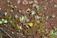
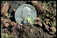
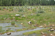
Diplacus pygmaeus, commonly known as Egg Lake monkeyflower, is a annual herb in the Phrymaceae that is found in California and elsewhere. It occurs within Great Basin scrub, Lower montane coniferous forest, Meadows and seeps, and Pinyon and juniper woodland, growing at elevations from 500 to 1840 meters. Diplacus pygmaeus is ranked 4.2, Plants of Limited Distribution, A Watch List; Moderately threatened in California.|
Scientific Name: Diplacus pygmaeus (A.L. Grant) G.L. Nesom |
||
|
Common Name: Egg Lake monkeyflower |
||
| Family: | Phrymaceae | |
| Element Code: | PDSCR1B2C0 | |
| USDA Plants Symbol: | ||
|
Synonyms/Other Names: |
||
| Name Status: |
JEF, FNA, POWO, IPNI, Tropicos |
|
| CA Rare Plant Rank: | 4.2 |
| Fed List: | None |
| State List: | None |
| Global Rank: | G4 |
|
State Rank: |
S3 |
| Other Status: | |
|
CRPR Changes: |
|
| Add Date: | 1974-01-01 |
| Date Edited: | 2025-10-29 |
| Lifeform: annual herb | ||||||||||||||
Blooming Period: May-Aug
|
||||||||||||||
|
Elevation:
500 - 1840 meters 1640 - 6035 feet |
||||||||||||||
General Habitats:
|
||||||||||||||
| Microhabitat Details: | ||||||||||||||
Microhabitat:
|
||||||||||||||
|
Notes: Rediscovered in 1980. Threatened by grazing, trampling, and hydrological alterations. Lassen NF has adopted species management guidelines. See Annals of the Missouri Botanical Garden 11(2-3):312 (1925) for original description, Phytoneuron 2012-39:1-60 (2012) for revised nomenclature, and Phytoneuron 2013-66:1-8 (2013) for taxonomic treatment. |
|
|
Threats: |
|
|
Taxonomy: |
|
| Threat List Total: | 8 | |
| Total EOs | % of EOs | |
| EOs with Threat Listed: | 20 | 61 % |
| THREAT LIST: | ||
|---|---|---|
| Grazing | 18 | 54% |
| Logging | 5 | 15% |
| Erosion/runoff | 2 | 6% |
| Foot traffic/trampling | 1 | 3% |
| Development | 1 | 3% |
| Recreational use (non-ORV) | 1 | 3% |
| Road/trail construction/maint. | 1 | 3% |
| Surface water diversion | 1 | 3% |
| Total Occurrences: | 33 | ||||
| Element Occurrence Ranks: | |||||
|---|---|---|---|---|---|
| A | B | C | D | X | U |
| 5 | 23 | 2 | 1 | 0 | 2 |
| Occurrence Status: | |||||
|---|---|---|---|---|---|
| Historical >20 Years | 33 | ||||
| Recent <=20 Years | 0 | ||||
| Presence: | |||||
|---|---|---|---|---|---|
| Presumed Extant | 33 | ||||
| Possibly Extirpated | 0 | ||||
| Presumed Extirpated | 0 | ||||
| California Endemic: | |||||||||||||
| California Island: | |||||||||||||
|
States: Name (Code) California (CA), Oregon (OR) |
|||||||||||||
|
California Counties and Islands: Name (Code) Lassen (LAS), Modoc (MOD), Plumas (PLU), Shasta (SHA), Siskiyou (SIS) |
|||||||||||||
|
Quads: Name (Quad Code) Almanor (4012122), Antelope Mtn. (4012058), Bullard Lake (4012078), Burney Falls (4112116), Champs Flat (4012068), Chester (4012132), Corders Reservoir (4012172), Crank Mountain (4112142), Donica Mtn. (4112132), Egg Lake (4112133), Grizzly Valley (3912085), Happy Camp Mtn. (4112141), Harvey Mtn. (4012161), Hermit Butte (4112037), Jellico (4012173), Jess Valley (4112023), Knobcone Butte (4112151), Letterbox Hill (4112018), Lookout (4112122), Payne Peak (4112053), Pease Flat (4112085), Perez (4112163), Pine Creek Valley (4012151), Poison Lake (4012162), Spalding Tract (4012067), Stover Mtn. (4012133), Straylor Lake (4012171), Swains Hole (4012163), Timbered Crater (4112124), Whitehorse (4112134) |
|||||||||||||
Notes:
|
|||||||||||||
 Presumed Extant
Click on quad for name. Hold Shift Key to use mouse scroll wheel


