Taxon Details
Silene bolanderi
Bolander's catchfly
View Report Copy Link Calflora eFlora CCH CalPhotos iNaturalist
Taxon Summary:
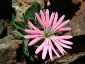
Silene bolanderi, commonly known as Bolander's catchfly, is a perennial herb in the Caryophyllaceae that is found only in California. It occurs within Chaparral (edges), Cismontane woodland, Lower montane coniferous forest, Meadows and seeps, and North Coast coniferous forest, growing at elevations from 420 to 1150 meters. Silene bolanderi is ranked 1B.2, Plants Rare, Threatened or Endangered in California and Elsewhere; Moderately threatened in California.|
Scientific Name: Silene bolanderi A. Gray |
||
|
Common Name: Bolander's catchfly |
||
| Family: | Caryophyllaceae | |
| Element Code: | PDCAR0U2L0 | |
| USDA Plants Symbol: | ||
|
Synonyms/Other Names: |
||
| Name Status: |
JEF, FNA, POWO, IPNI, Tropicos |
|
| CA Rare Plant Rank: | 1B.2 |
| Fed List: | None |
| State List: | None |
| Global Rank: | G2 |
|
State Rank: |
S2 |
| Other Status: | BLM_S |
|
CRPR Changes: added to 1B.2 on 2021-07-30 |
|
| Add Date: | 2021-07-30 |
| Date Edited: | 2025-10-29 |
| Lifeform: perennial herb | ||||||||||||||
Blooming Period: May-Jun
|
||||||||||||||
|
Elevation:
420 - 1150 meters 1380 - 3775 feet |
||||||||||||||
General Habitats:
|
||||||||||||||
| Microhabitat Details: Usually grassy openings, sometimes dry rocky slopes, canyons, or roadsides | ||||||||||||||
Microhabitat:
|
||||||||||||||
|
Notes: |
|
|
Threats: Potentially threatened by agricultural conversion, road construction and maintenance, grazing and trampling by livestock, and severe wildfires. |
|
|
Taxonomy: Similar to S. hookeri, S. nelsonii, and S. salmonacea; differentiated by its funnelform corolla (salverform in S. hookeri), usually pink petals with linear corona appendages >1 mm long (white petals with appendages lacking or <1 mm long in S. nelsonii), glabrous petal base margin (sparsely to densely ciliate in S. nelsonii), and radial androecium symmetry (bilateral in S. hookeri). |
|
| Threat List Total: | 0 | |
| Total EOs | % of EOs | |
| EOs with Threat Listed: | 0 | % |
| THREAT LIST: | ||
|---|---|---|
|
|
||
| Total Occurrences: | 30 | ||||
| Element Occurrence Ranks: | |||||
|---|---|---|---|---|---|
| A | B | C | D | X | U |
| 0 | 0 | 0 | 0 | 0 | 30 |
| Occurrence Status: | |||||
|---|---|---|---|---|---|
| Historical >20 Years | 12 | ||||
| Recent <=20 Years | 18 | ||||
| Presence: | |||||
|---|---|---|---|---|---|
| Presumed Extant | 30 | ||||
| Possibly Extirpated | 0 | ||||
| Presumed Extirpated | 0 | ||||
| California Endemic: | |||||||||||||
| California Island: | |||||||||||||
|
States: Name (Code) California (CA) |
|||||||||||||
|
California Counties and Islands: Name (Code) Humboldt (HUM), Lake (LAK), Mendocino (MEN), Trinity (TRI) |
|||||||||||||
|
Quads: Name (Quad Code) Black Lassic (4012335), Blake Mountain (4012355), Cahto Peak (3912365), Dinsmore (4012345), Fort Seward (4012326), Foster Mtn. (3912342), Iron Peak (3912374), Jamison Ridge (3912362), Larabee Valley (4012346), Laughlin Range (3912333), Laytonville (3912364), Lincoln Ridge (3912366), Longvale (3912354), Potter Valley (3912331), Purdys Gardens (3912311), Redwood Valley (3912332), Ruth Reservoir (4012334), Showers Mtn. (4012356), Sportshaven (4012344), Willits (3912343), Zenia (4012324) |
|||||||||||||
Notes:
|
|||||||||||||
 Presumed Extant
Click on quad for name. Hold Shift Key to use mouse scroll wheel

