Taxon Details
Cypripedium californicum
California lady's-slipper
View Report Copy Link Calflora eFlora CCH CalPhotos iNaturalist

© 2012 Barry Rice |
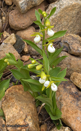
© 2008 Aaron Schusteff |
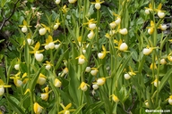
© 2016 Barry Rice |
Taxon Summary:
Cypripedium californicum, commonly known as California lady's-slipper, is a perennial rhizomatous herb in the Orchidaceae that is found in California and elsewhere. It occurs within Bogs and fens, and Lower montane coniferous forest, growing at elevations from 30 to 2750 meters. Cypripedium californicum is ranked 4.2, Plants of Limited Distribution, A Watch List; Moderately threatened in California.|
Scientific Name: Cypripedium californicum Gray |
||
|
Common Name: California lady's-slipper |
||
| Family: | Orchidaceae | |
| Element Code: | PMORC0Q040 | |
| USDA Plants Symbol: | CYCA4 | |
|
Synonyms/Other Names: |
||
| Name Status: |
JEF, FNA, POWO, IPNI, Tropicos |
|
| CA Rare Plant Rank: | 4.2 |
| Fed List: | None |
| State List: | None |
| Global Rank: | G3 |
|
State Rank: |
S4 |
| Other Status: | IUCN_EN; SB_CalBG/RSABG |
|
CRPR Changes: |
|
| Add Date: | 1980-01-01 |
| Date Edited: | 2025-02-04 |
| Lifeform: perennial rhizomatous herb | ||||||||||||||
Blooming Period: Apr-Aug(Sep)
|
||||||||||||||
|
Elevation:
30 - 2750 meters 100 - 9025 feet |
||||||||||||||
General Habitats:
|
||||||||||||||
| Microhabitat Details: | ||||||||||||||
Microhabitat:
|
||||||||||||||
|
Notes: Many protected populations on USFS land not reproducing. On watch list in OR. |
|
|
Threats: Threatened by horticultural collecting and logging. Potentially threatened by road maintenance. |
|
|
Taxonomy: See Proceedings of the American Academy of Arts and Sciences 7:389 (1868) for original description, and Fremontia 17(2):17-19 (1989) and The Wild Orchids of California, p. 62-64 (1995) by R. Coleman for species accounts. |
|
| Threat List Total: | 0 | |
| Total EOs | % of EOs | |
| EOs with Threat Listed: | 0 | 0 % |
| THREAT LIST: | ||
|---|---|---|
| Total Occurrences: | 0 | ||||
| Element Occurrence Ranks: | |||||
|---|---|---|---|---|---|
| A | B | C | D | X | U |
| 0 | 0 | 0 | 0 | 0 | 0 |
| Occurrence Status: | |||||
|---|---|---|---|---|---|
| Historical >20 Years | 0 | ||||
| Recent <=20 Years | 0 | ||||
| Presence: | |||||
|---|---|---|---|---|---|
| Presumed Extant | 0 | ||||
| Possibly Extirpated | 0 | ||||
| Presumed Extirpated | 0 | ||||
| California Endemic: | |||||||||||||
| California Island: | |||||||||||||
|
States: Name (Code) California (CA), Oregon (OR) |
|||||||||||||
|
California Counties and Islands: Name (Code) Butte (BUT), Del Norte (DNT), Humboldt (HUM), Lassen (LAS), Marin (MRN)*, Mendocino (MEN), Nevada (NEV), Plumas (PLU), Shasta (SHA), Siskiyou (SIS), Sonoma (SON), Tehama (TEH), Trinity (TRI) |
|||||||||||||
|
Quads: Name (Quad Code) Almanor (4012122), Bear Peak (4112365), Belden (4012113), Berry Creek (3912164), Blue Creek Mtn. (4112347), Brush Creek (3912163), Bully Choop Mtn. (4012257), Cant Hook Mtn. (4112368), Canyondam (4012121), Caribou (4012112), Carrville (4112216), Cascade (3912162), Cazadero (3812351), Cecil Lake (4112312), Chester (4012132), Chickabally Mtn. (4012236), Chicken Hawk Hill (4112214), China Mtn. (4112245), City of Mount Shasta (4112233), Covington Mill (4012287), Deadman Point (4112384), Devils Punchbowl (4112376), Duncans Mills (3812341), Dunsmuir (4112223), Dutch Creek (4112381), Elledge Peak (3912312), Fort Ross (3812352), Gasquet (4112378), Grouse Mtn. (4012376), Hamburg (4112371), Happy Camp (4112374), High Divide (4112481), High Plateau Mtn. (4112388), Hiouchi (4112471), Hoopa (4112316), Huckleberry Mtn. (4112363), Hurdygurdy Butte (4112377), Kangaroo Mtn. (4112382), Kimshew Point (3912184), Klamath Glen (4112358), Mount Eddy (4112234), Noble Butte (3912386), North Bloomfield (3912038), Onion Valley (3912078), Polar Bear Mtn. (4112385), Prescott Mtn. (4112366), Preston Peak (4112375), Pulga (3912174), Quincy (3912088), Rush Creek Lakes (4012278), San Rafael (3712285), Scott Mountain (4112236), Seven Lakes Basin (4112224), Shelly Creek Ridge (4112387), Ship Mountain (4112367), Siligo Peak (4012288), Smith River (4112482), Tangle Blue Lake (4112226), Tombs Creek (3812362), Trinity Center (4012286), Trinity Dam (4012277), Twain (4012111), Ukiah (3912322), Warm Springs Dam (3812361), Weed (4112244), Westwood West (4012131), Whisky Bill Peak (4112215), Wildwood (4012341), Willow Creek (4012386), Ycatapom Peak (4112217) |
|||||||||||||
Notes:
|
|||||||||||||
 Presumed Extant
Click on quad for name. Hold Shift Key to use mouse scroll wheel