Taxon Details
Gratiola heterosepala
Boggs Lake hedge-hyssop
View Report Copy Link Calflora eFlora CCH CalPhotos iNaturalist

©2004 Carol W. Witham |
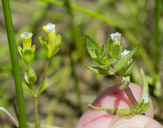
©2016 Jeb Bjerke |
©1986 California Native Plant Society |
Taxon Summary:
Gratiola heterosepala, commonly known as Boggs Lake hedge-hyssop, is a annual herb in the Plantaginaceae that is found in California and elsewhere. It occurs within Marshes and swamps (lake margins), and Vernal pools, growing at elevations from 10 to 2375 meters. Gratiola heterosepala is ranked 1B.2, Plants Rare, Threatened or Endangered in California and Elsewhere; Moderately threatened in California.|
Scientific Name: Gratiola heterosepala Mason & Bacig. |
||
|
Common Name: Boggs Lake hedge-hyssop |
||
| Family: | Plantaginaceae | |
| Element Code: | PDSCR0R060 | |
| USDA Plants Symbol: | GRHE | |
|
Synonyms/Other Names: |
||
| Name Status: |
JEF, FNA, POWO, IPNI, Tropicos |
|
| CA Rare Plant Rank: | 1B.2 |
| Fed List: | None |
| State List: | CE (1978-11-01) |
| Global Rank: | G2 |
|
State Rank: |
S2 |
| Other Status: | BLM_S |
|
CRPR Changes: |
|
| Add Date: | 1974-01-01 |
| Date Edited: | 2022-01-05 |
| Lifeform: annual herb | ||||||||||||||
Blooming Period: Apr-Aug
|
||||||||||||||
|
Elevation:
10 - 2375 meters 35 - 7790 feet |
||||||||||||||
General Habitats:
|
||||||||||||||
| Microhabitat Details: | ||||||||||||||
Microhabitat:
|
||||||||||||||
| Threat List Total: | 16 | |
| Total EOs | % of EOs | |
| EOs with Threat Listed: | 75 | 68 % |
| THREAT LIST: | ||
|---|---|---|
| Grazing | 54 | 49% |
| Foot traffic/trampling | 19 | 17% |
| Development | 16 | 14% |
| Other | 5 | 4% |
| Altered flood/tidal/hydrologic regime | 4 | 3% |
| Landfill | 2 | 1% |
| Mining | 2 | 1% |
| Non-native animal impacts | 2 | 1% |
| Non-native plant impacts | 2 | 1% |
| Recreational use (non-ORV) | 2 | 1% |
| Road/trail construction/maint. | 2 | 1% |
| Agriculture | 2 | 1% |
| Feral pigs | 2 | 1% |
| ORV activity | 1 | 0% |
| Biocides | 1 | 0% |
| Erosion/runoff | 1 | 0% |
| Total Occurrences: | 110 | ||||
| Element Occurrence Ranks: | |||||
|---|---|---|---|---|---|
| A | B | C | D | X | U |
| 21 | 37 | 13 | 3 | 5 | 31 |
| Occurrence Status: | |||||
|---|---|---|---|---|---|
| Historical >20 Years | 74 | ||||
| Recent <=20 Years | 36 | ||||
| Presence: | |||||
|---|---|---|---|---|---|
| Presumed Extant | 105 | ||||
| Possibly Extirpated | 1 | ||||
| Presumed Extirpated | 4 | ||||
| California Endemic: | |||||||||||||
| California Island: | |||||||||||||
|
States: Name (Code) California (CA), Oregon (OR) |
|||||||||||||
|
California Counties and Islands: Name (Code) Fresno (FRE), Lake (LAK), Lassen (LAS), Madera (MAD), Mendocino (MEN), Merced (MER), Modoc (MOD), Placer (PLA), Sacramento (SAC), San Joaquin (SJQ), Shasta (SHA), Siskiyou (SIS), Solano (SOL), Sonoma (SON), Tehama (TEH) |
|||||||||||||
|
Quads: Name (Quad Code) Ambrose (4112058), Ambrose Valley (4112027), Balls Ferry (4012242), Bend (4012232), Big Sage Reservoir (4112056), Boles Meadows West (4112068), Buffalo Creek (3812152), Bullard Lake (4012078), Cable Mtn. (4012183), Carmichael (3812153), Champs Flat (4012068), Clearlake Highlands (3812286), Corning (3912282), Dales (4012231), Dead Horse Reservoir (4112065), Dorris Reservoir (4112044), Dozier (3812137), Eagle Peak (4112032), Egg Lake (4112133), Elk Grove (3812143), Goose Creek (3812131), Hager Basin (4112077), Henleyville (3912283), Hermit Butte (4112037), Kelseyville (3812287), Knobcone Butte (4112151), Lincoln (3812183), Los Molinos (4012211), Madeline (4112014), Mahogany Ridge (4112055), Mark West Springs (3812256), Medicine Lake (4112155), Middletown (3812275), Millerton Lake East (3711915), Murken Bench (4012174), Old Station (4012164), Palo Cedro (4012252), Petes Valley (4012054), Pittville (4112113), Planada (3712033), Pleasant Grove (3812174), Pothole Valley (4112078), Purdys Gardens (3912311), Richardson Springs NW (3912188), Rimrock Lake (4112162), Rio Linda (3812164)*, Rocklin (3812172), Roseville (3812173), Sheridan (3812184), Sloughhouse (3812142), South Mtn. (4112076), Spalding Tract (4012067), Swains Hole (4012163), Timbered Crater (4112124), Tule Mountain (4112024), Tuscan Buttes Ne (4012241), Vina (3912281), Washington Mtn. (4112048), West of Snowstorm Mtn. (4012064), Whittemore Ridge (4112066) |
|||||||||||||
Notes:
|
|||||||||||||
 Presumed Extant
Click on quad for name. Hold Shift Key to use mouse scroll wheel