Species Details
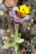
Diplacus pulchellus
yellow-lip pansy monkeyflower
Download Report Calflora eFlora CCH CalPhotos|
Scientific Name: Diplacus pulchellus (Drew ex Greene) G.L. Nesom |
||
|
Common Name: yellow-lip pansy monkeyflower |
||
| Family: | Phrymaceae | |
| Element Code: | PDSCR1B280 | |
| USDA Plants Symbol: | ||
|
Synonyms/Other Names: |
||
| CA Rare Plant Rank: | 1B.2 |
| Fed List: | None |
| State List: | None |
| Global Rank: | G2 |
|
State Rank: |
S2 |
| Other Status: | BLM_S; SB_SBBG; USFS_S |
|
CRPR Changes: |
|
| Add Date: | 1974-01-01 |
| Date Edited: | 2022-12-06 |
| Lifeform: annual herb | ||||||||||||||
Blooming Period: Apr-Jul
|
||||||||||||||
|
Elevation:
600 - 2000 meters 1970 - 6560 feet |
||||||||||||||
General Habitats:
|
||||||||||||||
| Microhabitat Details: | ||||||||||||||
Microhabitat:
|
||||||||||||||
|
Notes: Threatened by vehicles, logging, non-native plants, and grazing, and potentially threatened by development. See Pittonia 2:104 (1890) for original description, Phytoneuron 2012-39:1-60 (2012) for revised nomenclature, and Phytoneuron 2013-66:1-8 (2013) for taxonomic treatment. |
|
|
Threats: |
|
|
Taxonomy: |
|
| Threat List Total: | 14 | |
| Total EOs | % of EOs | |
| EOs with Threat Listed: | 40 | 51 % |
| THREAT LIST: | ||
|---|---|---|
| ORV activity | 23 | 29% |
| Logging | 14 | 17% |
| Road/trail construction/maint. | 12 | 15% |
| Grazing | 9 | 11% |
| Recreational use (non-ORV) | 6 | 7% |
| Development | 3 | 3% |
| Altered flood/tidal/hydrologic regime | 2 | 2% |
| Non-native plant impacts | 2 | 2% |
| Other | 2 | 2% |
| Dam/Inundation | 1 | 1% |
| Erosion/runoff | 1 | 1% |
| Foot traffic/trampling | 1 | 1% |
| Vandalism/dumping/litter | 1 | 1% |
| Wood cutting or brush clearing | 1 | 1% |
| Total Occurrences: | 78 | ||||
| Element Occurrence Ranks: | |||||
|---|---|---|---|---|---|
| A | B | C | D | X | U |
| 7 | 23 | 2 | 1 | 3 | 42 |
| Occurrence Status: | |||||
|---|---|---|---|---|---|
| Historical >20 Years | 38 | ||||
| Recent <=20 Years | 40 | ||||
| Presence: | |||||
|---|---|---|---|---|---|
| Presumed Extant | 75 | ||||
| Possibly Extirpated | 3 | ||||
| Presumed Extirpated | 0 | ||||
| California Endemic: | |||||||||||||
| California Island: | |||||||||||||
|
States: Name (Code) California (CA) |
|||||||||||||
|
California Counties and Islands: Name (Code) Calaveras (CAL), El Dorado (ELD), Mariposa (MPA), Tuolumne (TUO) |
|||||||||||||
|
Quads: Name (Quad Code) Ackerson Mtn. (3711977), Angels Camp (3812015), Ascension Mtn. (3711978), Buckhorn Peak (3712061), Buckingham Mtn. (3711957), Caldor (3812054), Cherry Lake South (3711988), Columbia (3812014), Columbia Se (3812013), Coulterville (3712062), Crandall Peak (3812022), Devils Nose (3812044), Dorrington (3812033), Duckwall Mtn. (3712081), El Capitan (3711966), El Portal (3711967), Fort Mountain (3812034), Garnet Hill (3812043), Groveland (3712072), Half Dome (3711965), Hetch Hetchy Reservoir (3711986), Hull Creek (3812011), Jawbone Ridge (3712071), Kibbie Lake (3811917), Lake Eleanor (3711987), Mariposa (3711948), Murphys (3812024), Omo Ranch (3812055), Rail Road Flat (3812035), Standard (3712083), Stanislaus (3812023), Strawberry (3812021), Stumpfield Mtn. (3711947), Tamarack Flat (3711976), Twain Harte (3812012), Yosemite Falls (3711975) |
|||||||||||||
Notes:
|
|||||||||||||
 Presumed Extant
Click on quad for name. Hold Shift Key to use mouse scroll wheel


