Taxon Details
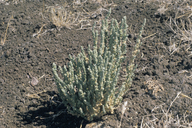
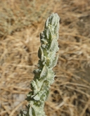
Atriplex coronata var. coronata
crownscale
View Report Copy Link Calflora eFlora CCH CalPhotos iNaturalist
© 1994 Robert E. Preston, Ph.D. |
© 2010 Neal Kramer |

© 2010 Chris Winchell |
Taxon Summary:
Atriplex coronata var. coronata, commonly known as crownscale, is a annual herb in the Amaranthaceae that is found only in California. It occurs within Chenopod scrub, Valley and foothill grassland, and Vernal pools, growing at elevations from 1 to 590 meters. Atriplex coronata var. coronata is ranked 4.2, Plants of Limited Distribution, A Watch List; Moderately threatened in California.|
Scientific Name: Atriplex coronata Wats. var. coronata |
||
|
Common Name: crownscale |
||
| Family: | Amaranthaceae | |
| Element Code: | PDCHE040C3 | |
| USDA Plants Symbol: | ATCOC | |
|
Synonyms/Other Names: |
||
| Name Status: |
JEF, FNA, POWO, IPNI, Tropicos |
|
| CA Rare Plant Rank: | 4.2 |
| Fed List: | None |
| State List: | None |
| Global Rank: | G4T3 |
|
State Rank: |
S3 |
| Other Status: | SB_CalBG/RSABG |
|
CRPR Changes: |
|
| Add Date: | 1994-01-01 |
| Date Edited: | 2026-05-05 |
| Lifeform: annual herb | ||||||||||||||
Blooming Period: Mar-Oct
|
||||||||||||||
|
Elevation:
1 - 590 meters 5 - 1935 feet |
||||||||||||||
General Habitats:
|
||||||||||||||
| Microhabitat Details: | ||||||||||||||
Microhabitat:
|
||||||||||||||
| Threat List Total: | 0 | |
| Total EOs | % of EOs | |
| EOs with Threat Listed: | 0 | 0 % |
| THREAT LIST: | ||
|---|---|---|
| Total Occurrences: | 0 | ||||
| Element Occurrence Ranks: | |||||
|---|---|---|---|---|---|
| A | B | C | D | X | U |
| 0 | 0 | 0 | 0 | 0 | 0 |
| Occurrence Status: | |||||
|---|---|---|---|---|---|
| Historical >20 Years | 0 | ||||
| Recent <=20 Years | 0 | ||||
| Presence: | |||||
|---|---|---|---|---|---|
| Presumed Extant | 0 | ||||
| Possibly Extirpated | 0 | ||||
| Presumed Extirpated | 0 | ||||
| California Endemic: | |||||||||||||
| California Island: | |||||||||||||
|
States: Name (Code) California (CA) |
|||||||||||||
|
California Counties and Islands: Name (Code) Alameda (ALA), Contra Costa (CCA), Fresno (FRE), Kern (KRN), Kings (KNG), Merced (MER), Monterey (MNT), San Benito (SBT), San Luis Obispo (SLO), Solano (SOL), Stanislaus (STA), Tulare (TUL) |
|||||||||||||
|
Quads: Name (Quad Code) Allensworth (3511974), Altamont (3712166), Antioch North (3812117), Antioch South (3712187), Brentwood (3712186), Byron Hot Springs (3712176), California Valley (3512031), Cholame (3512063), Cholame Valley (3512073), Clifton Court Forebay (3712175), Coal Oil Canyon (3511911), Cuyama (3411985), Delano West (3511973), Denverton (3812128), Domengine Ranch (3612033), East Elk Hills (3511934), Elkhorn Hills (3511915), Guijarral Hills (3612022), Gustine (3712038), Hacienda Ranch (3511975), Holland Canyon (3512052), Kettleman Plain (3512081), Laguna Seca Ranch (3612077), Livermore (3712167), Lokern (3511945), Lost Hills (3511956), Lost Hills NE (3511965), Mouth of Kern (3511923), New Cuyama (3411986), Orchard Peak (3512062), Ortigalita Peak NW (3612088), Painted Rock (3511927), Reward (3511936), Ripon (3712162), Sawtooth Ridge (3512061), Semitropic (3511955), Simmler (3511938), Stevinson (3712037), Taft (3511924), Tumey Hills (3612056), Tupman (3511933), Turner Ranch (3712026), Vernalis (3712163), Vine Hill (3812211), Wasco NW (3511964), Wells Ranch (3511916), Woodward Island (3712185) |
|||||||||||||
Notes:
|
|||||||||||||
 Presumed Extant
Click on quad for name. Hold Shift Key to use mouse scroll wheel