Taxon Details
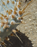
Opuntia basilaris var. treleasei
Bakersfield cactus
View Report Copy Link Calflora eFlora CCH CalPhotos iNaturalist

Keir Morse |
Neal Kramer |
Taxon Summary:
Opuntia basilaris var. treleasei, commonly known as Bakersfield cactus, is a perennial stem in the Cactaceae that is found only in California. It occurs within Chenopod scrub, Cismontane woodland, and Valley and foothill grassland, growing at elevations from 100 to 1450 meters. Opuntia basilaris var. treleasei is ranked 1B.1, Plants Rare, Threatened or Endangered in California and Elsewhere; Seriously threatened in California.|
Scientific Name: Opuntia basilaris Engelm. & Bigel. var. treleasei (Coult.) Toumey |
||
|
Common Name: Bakersfield cactus |
||
| Family: | Cactaceae | |
| Element Code: | PDCAC0D055 | |
| USDA Plants Symbol: | OPBAT | |
|
Synonyms/Other Names: |
||
| Name Status: |
JEF, FNA, POWO, IPNI, Tropicos |
|
| CA Rare Plant Rank: | 1B.1 |
| Fed List: | FE (1990-07-19) |
| State List: | CE (1990-01-01) |
| Global Rank: | G5T1 |
|
State Rank: |
S1 |
| Other Status: | SB_CalBG/RSABG |
|
CRPR Changes: |
|
| Add Date: | 1974-01-01 |
| Date Edited: | 2025-10-29 |
| Lifeform: perennial stem | ||||||||||||||
Blooming Period: Apr-May
|
||||||||||||||
|
Elevation:
100 - 1450 meters 330 - 4755 feet |
||||||||||||||
General Habitats:
|
||||||||||||||
| Microhabitat Details: | ||||||||||||||
Microhabitat:
|
||||||||||||||
|
Notes: USFWS uses the name O. treleasei. See Contributions from the U.S. National Herbarium 3:434 (1896) for original description, Wasmann Journal of Biology 25:289-290 (1967) for species account, and Madroño 39(1):79 (1992) for information on a new population. |
|
|
Threats: Threatened by energy development, agricultural conversion, grazing, mining, vehicles, and especially urbanization in the Bakersfield area. |
|
|
Taxonomy: |
|
| Threat List Total: | 19 | |
| Total EOs | % of EOs | |
| EOs with Threat Listed: | 47 | 76 % |
| THREAT LIST: | ||
|---|---|---|
| Grazing | 27 | 43% |
| Road/trail construction/maint. | 19 | 30% |
| Vandalism/dumping/litter | 12 | 19% |
| Foot traffic/trampling | 12 | 19% |
| ORV activity | 12 | 19% |
| Mining | 11 | 17% |
| Erosion/runoff | 11 | 17% |
| Development | 11 | 17% |
| Agriculture | 9 | 14% |
| Other | 8 | 12% |
| Recreational use (non-ORV) | 7 | 11% |
| Non-native plant impacts | 6 | 9% |
| Improper burning regime | 6 | 9% |
| Disking | 4 | 6% |
| Biocides | 3 | 4% |
| Waterway bank protection/maintenance | 3 | 4% |
| Pollution | 1 | 1% |
| Landfill | 1 | 1% |
| Altered flood/tidal/hydrologic regime | 1 | 1% |
| Total Occurrences: | 62 | ||||
| Element Occurrence Ranks: | |||||
|---|---|---|---|---|---|
| A | B | C | D | X | U |
| 0 | 12 | 19 | 9 | 11 | 11 |
| Occurrence Status: | |||||
|---|---|---|---|---|---|
| Historical >20 Years | 17 | ||||
| Recent <=20 Years | 45 | ||||
| Presence: | |||||
|---|---|---|---|---|---|
| Presumed Extant | 51 | ||||
| Possibly Extirpated | 2 | ||||
| Presumed Extirpated | 9 | ||||
| California Endemic: | |||||||||||||
| California Island: | |||||||||||||
|
States: Name (Code) California (CA) |
|||||||||||||
|
California Counties and Islands: Name (Code) Kern (KRN) |
|||||||||||||
|
Quads: Name (Quad Code) Arvin (3511827), Bena (3511836), Coal Oil Canyon (3511911), Conner SW (3511912), Eagle Rest Peak (3411982), Edison (3511837), Grapevine (3411888), Lamont (3511838)*, Mettler (3511818), Mt. Adelaide (3511846), North of Oildale (3511951), Oil Center (3511848), Oildale (3511941)*, Oiler Peak (3511835)*, Rio Bravo Ranch (3511847), Tejon Hills (3511817), Weed Patch (3511828), Woody (3511867) |
|||||||||||||
Notes:
|
|||||||||||||
 Presumed Extant
Click on quad for name. Hold Shift Key to use mouse scroll wheel