Taxon Details
Lilium humboldtii ssp. humboldtii
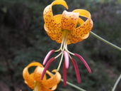
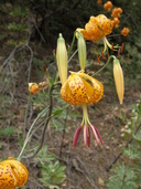
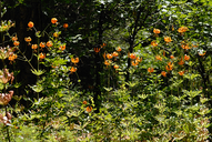
Humboldt lily
View Report Copy Link Calflora eFlora CCH CalPhotos iNaturalist
© 2008 Sierra Pacific Industries |
© 2008 Sierra Pacific Industries |
© 2011 Dee E. Warenycia |
Taxon Summary:
Lilium humboldtii ssp. humboldtii, commonly known as Humboldt lily, is a perennial bulbiferous herb in the Liliaceae that is found only in California. It occurs within Chaparral, Cismontane woodland, and Lower montane coniferous forest, growing at elevations from 90 to 1280 meters. Lilium humboldtii ssp. humboldtii is ranked 4.2, Plants of Limited Distribution, A Watch List; Moderately threatened in California.|
Scientific Name: Lilium humboldtii Roezl & Leichtl. ssp. humboldtii |
||
|
Common Name: Humboldt lily |
||
| Family: | Liliaceae | |
| Element Code: | PMLIL1A071 | |
| USDA Plants Symbol: | LIHUH | |
|
Synonyms/Other Names: |
||
| Name Status: |
JEF, FNA, POWO, IPNI, Tropicos |
|
| CA Rare Plant Rank: | 4.2 |
| Fed List: | None |
| State List: | None |
| Global Rank: | G4T3 |
|
State Rank: |
S3 |
| Other Status: | SB_UCSC |
|
CRPR Changes: |
|
| Add Date: | 1994-01-01 |
| Date Edited: | 2025-10-29 |
| Lifeform: perennial bulbiferous herb | ||||||||||||||
Blooming Period: May-Jul(Aug)
|
||||||||||||||
|
Elevation:
90 - 1280 meters 295 - 4200 feet |
||||||||||||||
General Habitats:
|
||||||||||||||
| Microhabitat Details: | ||||||||||||||
Microhabitat:
|
||||||||||||||
| Threat List Total: | 0 | |
| Total EOs | % of EOs | |
| EOs with Threat Listed: | 0 | 0 % |
| THREAT LIST: | ||
|---|---|---|
| Total Occurrences: | 0 | ||||
| Element Occurrence Ranks: | |||||
|---|---|---|---|---|---|
| A | B | C | D | X | U |
| 0 | 0 | 0 | 0 | 0 | 0 |
| Occurrence Status: | |||||
|---|---|---|---|---|---|
| Historical >20 Years | 0 | ||||
| Recent <=20 Years | 0 | ||||
| Presence: | |||||
|---|---|---|---|---|---|
| Presumed Extant | 0 | ||||
| Possibly Extirpated | 0 | ||||
| Presumed Extirpated | 0 | ||||
| California Endemic: | |||||||||||||
| California Island: | |||||||||||||
|
States: Name (Code) California (CA) |
|||||||||||||
|
California Counties and Islands: Name (Code) Amador (AMA), Butte (BUT), Calaveras (CAL), El Dorado (ELD), Los Angeles (LAX), Nevada (NEV), Placer (PLA), Plumas (PLU), San Diego (SDG), Santa Barbara (SBA), Sierra (SIE), Tehama (TEH), Yuba (YUB) |
|||||||||||||
|
Quads: Name (Quad Code) Auburn (3812181), Azusa (3411728), Berry Creek (3912164), Butte Meadows (4012115), Camino (3812066), Campbell Mound (3912187), Camptonville (3912141), Cascade (3912162), Challenge (3912142), Chicago Park (3912028), Clipper Mills (3912152), Cohasset (3912186), Colfax (3912018), Devils Nose (3812044), Devils Parade Ground (4012116), Dorrington (3812033), Dutch Flat (3912027), Forbestown (3912153), Fort Mountain (3812034), French Corral (3912132), Garnet Hill (3812043), Georgetown (3812087), Grass Valley (3912121), Lake Combie (3912111), Lompoc Hills (3412054), Nevada City (3912131), North Bloomfield (3912038), Oroville (3912155), Oroville Dam (3912154), Otay Mountain (3211657), Paradise East (3912175), Paradise West (3912176), Pike (3912048), Pilot Hill (3812171), Pine Grove (3812046), Point Conception (3412044), Point Dume (3411817), Pulga (3912174), Rackerby (3912143), Santa Rosa Hills (3412053), Stanislaus (3812023), Stirling City (3912185), Strawberry Valley (3912151), West Point (3812045), Wolf (3912112) |
|||||||||||||
Notes:
|
|||||||||||||
 Presumed Extant
Click on quad for name. Hold Shift Key to use mouse scroll wheel