Taxon Details
Antirrhinum ovatum
oval-leaved snapdragon
View Report Copy Link Calflora eFlora CCH CalPhotos iNaturalist
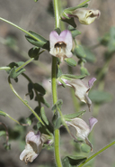
© 2013 Chris Winchell |

© 2013 Chris Winchell |

© 2013 Chris Winchell |
Taxon Summary:
Antirrhinum ovatum, commonly known as oval-leaved snapdragon, is a annual herb in the Plantaginaceae that is found only in California. It occurs within Chaparral, Cismontane woodland, Pinyon and juniper woodland, and Valley and foothill grassland, growing at elevations from 200 to 1000 meters. Antirrhinum ovatum is ranked 4.2, Plants of Limited Distribution, A Watch List; Moderately threatened in California.|
Scientific Name: Antirrhinum ovatum Eastw. |
||
|
Common Name: oval-leaved snapdragon |
||
| Family: | Plantaginaceae | |
| Element Code: | PDSCR2K010 | |
| USDA Plants Symbol: | ||
|
Synonyms/Other Names: |
||
| Name Status: |
JEF, FNA, POWO, IPNI, Tropicos |
|
| CA Rare Plant Rank: | 4.2 |
| Fed List: | None |
| State List: | None |
| Global Rank: | G3 |
|
State Rank: |
S3 |
| Other Status: | |
|
CRPR Changes: |
|
| Add Date: | 1974-01-01 |
| Date Edited: | 2025-10-29 |
| Lifeform: annual herb | ||||||||||||||
Blooming Period: May-Nov
|
||||||||||||||
|
Elevation:
200 - 1000 meters 655 - 3280 feet |
||||||||||||||
General Habitats:
|
||||||||||||||
| Microhabitat Details: sometimes gypsum | ||||||||||||||
Microhabitat:
|
||||||||||||||
| Threat List Total: | 5 | |
| Total EOs | % of EOs | |
| EOs with Threat Listed: | 3 | 19 % |
| THREAT LIST: | ||
|---|---|---|
| Grazing | 3 | 18% |
| Non-native plant impacts | 1 | 6% |
| Road/trail construction/maint. | 1 | 6% |
| Agriculture | 1 | 6% |
| Development | 1 | 6% |
| Total Occurrences: | 16 | ||||
| Element Occurrence Ranks: | |||||
|---|---|---|---|---|---|
| A | B | C | D | X | U |
| 0 | 0 | 0 | 0 | 1 | 15 |
| Occurrence Status: | |||||
|---|---|---|---|---|---|
| Historical >20 Years | 16 | ||||
| Recent <=20 Years | 0 | ||||
| Presence: | |||||
|---|---|---|---|---|---|
| Presumed Extant | 15 | ||||
| Possibly Extirpated | 1 | ||||
| Presumed Extirpated | 0 | ||||
| California Endemic: | |||||||||||||
| California Island: | |||||||||||||
|
States: Name (Code) California (CA) |
|||||||||||||
|
California Counties and Islands: Name (Code) Fresno (FRE), Kern (KRN), Monterey (MNT), San Benito (SBT), San Luis Obispo (SLO), Ventura (VEN) |
|||||||||||||
|
Quads: Name (Quad Code) Apache Canyon (3411973), Ballinger Canyon (3411984), Bates Canyon (3411988), Blackwells Corner (3511957), Caliente Mtn. (3511917), California Valley (3512031), Carneros Rocks (3511947), Chimineas Ranch (3511928), Cholame (3512063), Cholame Hills (3512074), Cholame Valley (3512073), Cuyama Peak (3411974), Elkhorn Hills (3511915), Estrella (3512065), Hepsedam Peak (3612037), Hernandez Reservoir (3612047), La Panza NE (3512041), Las Yeguas Ranch (3511948), Lonoak (3612038), Orchard Peak (3512062), Packwood Creek (3512051), Painted Rock (3511927), Panorama Hills (3511926), Paso Robles (3512066), Peak Mountain (3411987), Priest Valley (3612026), Rock Spring Peak (3612048), San Benito Mtn. (3612036), Shale Point (3511958), Simmler (3511938), Taylor Canyon (3511918), Tent Hills (3512072), The Dark Hole (3512083), Wells Ranch (3511916) |
|||||||||||||
Notes:
|
|||||||||||||
 Presumed Extant
Click on quad for name. Hold Shift Key to use mouse scroll wheel