Taxon Details
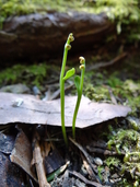
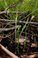
Botrychium montanum
western goblin
View Report Copy Link Calflora eFlora CCH CalPhotos iNaturalist
©2012 Belinda Lo |

©2020 Belinda Lo |
©2019 Belinda Lo |
Taxon Summary:
Botrychium montanum, commonly known as western goblin, is a perennial rhizomatous herb in the Ophioglossaceae that is found in California and elsewhere. It occurs within Lower montane coniferous forest, Meadows and seeps, and Upper montane coniferous forest, growing at elevations from 1465 to 2180 meters. Botrychium montanum is ranked 2B.1, Plants Rare, Threatened, or Endangered in California, But More Common Elsewhere; Seriously threatened in California.|
Scientific Name: Botrychium montanum W. Wagner |
||
|
Common Name: western goblin |
||
| Family: | Ophioglossaceae | |
| Element Code: | PPOPH010K0 | |
| USDA Plants Symbol: | BOMO | |
|
Synonyms/Other Names: |
||
| Name Status: |
JEF, FNA, POWO, IPNI, Tropicos |
|
| CA Rare Plant Rank: | 2B.1 |
| Fed List: | None |
| State List: | None |
| Global Rank: | G3G4 |
|
State Rank: |
S3 |
| Other Status: | USFS_S |
|
CRPR Changes: |
|
| Add Date: | 1994-01-01 |
| Date Edited: | 2025-10-29 |
| Lifeform: perennial rhizomatous herb | ||||||||||||||
Blooming Period: Jul-Sep
|
||||||||||||||
|
Elevation:
1465 - 2180 meters 4805 - 7155 feet |
||||||||||||||
General Habitats:
|
||||||||||||||
| Microhabitat Details: | ||||||||||||||
Microhabitat:
|
||||||||||||||
|
Notes: Potentially threatened by vehicles, road deconstruction, and logging. Possibly threatened by habitat loss, grazing, trampling, foot traffic, and hydrological alterations. Endangered in OR. See American Fern Journal 71(1):29 (1981) for original description, and Madroño 36(2):131-136 (1989) for first CA records. |
|
|
Threats: |
|
|
Taxonomy: |
|
| Threat List Total: | 12 | |
| Total EOs | % of EOs | |
| EOs with Threat Listed: | 50 | 72 % |
| THREAT LIST: | ||
|---|---|---|
| Logging | 25 | 36% |
| Grazing | 19 | 27% |
| Foot traffic/trampling | 10 | 14% |
| Other | 6 | 8% |
| Road/trail construction/maint. | 6 | 8% |
| Altered flood/tidal/hydrologic regime | 5 | 7% |
| Surface water diversion | 4 | 5% |
| Non-native plant impacts | 3 | 4% |
| ORV activity | 3 | 4% |
| Recreational use (non-ORV) | 2 | 2% |
| Erosion/runoff | 1 | 1% |
| Wood cutting or brush clearing | 1 | 1% |
| Total Occurrences: | 69 | ||||
| Element Occurrence Ranks: | |||||
|---|---|---|---|---|---|
| A | B | C | D | X | U |
| 6 | 17 | 13 | 4 | 1 | 28 |
| Occurrence Status: | |||||
|---|---|---|---|---|---|
| Historical >20 Years | 13 | ||||
| Recent <=20 Years | 56 | ||||
| Presence: | |||||
|---|---|---|---|---|---|
| Presumed Extant | 68 | ||||
| Possibly Extirpated | 0 | ||||
| Presumed Extirpated | 1 | ||||
| California Endemic: | |||||||||||||
| California Island: | |||||||||||||
|
States: Name (Code) Alaska (AK), California (CA), Idaho (ID), Montana (MT), Oregon (OR), Washington (WA) |
|||||||||||||
|
California Counties and Islands: Name (Code) Amador (AMA), Butte (BUT), El Dorado (ELD), Fresno (FRE), Lassen (LAS), Madera (MAD), Modoc (MOD), Plumas (PLU), Shasta (SHA), Sierra (SIE), Siskiyou (SIS), Tehama (TEH), Trinity (TRI), Tuolumne (TUO) |
|||||||||||||
|
Quads: Name (Quad Code) Antelope Mtn. (4012058), Bear River Reservoir (3812052), Belden (4012113), Boards Crossing (3812032), Davis Creek (4112063), Fredonyer Pass (4012037), Grays Peak (4012146), Homewood (3912012), Humboldt Peak (4012124), Jonesville (4012114), Kaiser Peak (3711932), Kimshew Point (3912184), Kyburz (3812073), La Porte (3912068), Lassen Peak (4012145), Leek Spring Hill (3812063), Little Shuteye Peak (3711944), Loon Lake (3812083), Mineral (4012135), Mt. Harkness (4012143), Mt. Henry (3711827), Mumbo Basin (4112225), Pegleg Mtn. (4012048), Red Cinder (4012142), Roop Mountain (4012047), Sattley (3912054), Swain Mountain (4012141), Tragedy Spring (3812062), Viola (4012156), West Haight Mtn. (4112251), Westwood West (4012131) |
|||||||||||||
Notes:
|
|||||||||||||
 Presumed Extant
Click on quad for name. Hold Shift Key to use mouse scroll wheel