Taxon Details
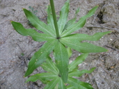
Lilium humboldtii ssp. ocellatum
ocellated Humboldt lily
View Report Copy Link Calflora eFlora CCH CalPhotos iNaturalist
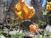
© 2008 Thomas Stoughton |

© 2011 Neal Kramer |
© 2008 Thomas Stoughton |
Taxon Summary:
Lilium humboldtii ssp. ocellatum, commonly known as ocellated Humboldt lily, is a perennial bulbiferous herb in the Liliaceae that is found only in California. It occurs within Chaparral, Cismontane woodland, Coastal scrub, Lower montane coniferous forest, and Riparian woodland, growing at elevations from 30 to 1800 meters. Lilium humboldtii ssp. ocellatum is ranked 4.2, Plants of Limited Distribution, A Watch List; Moderately threatened in California.|
Scientific Name: Lilium humboldtii Roezl & Leichtl. ssp. ocellatum (Kell.) Thorne |
||
|
Common Name: ocellated Humboldt lily |
||
| Family: | Liliaceae | |
| Element Code: | PMLIL1A072 | |
| USDA Plants Symbol: | LIHUO2 | |
|
Synonyms/Other Names: |
||
| Name Status: |
JEF, FNA, POWO, IPNI, Tropicos |
|
| CA Rare Plant Rank: | 4.2 |
| Fed List: | None |
| State List: | None |
| Global Rank: | G4T4? |
|
State Rank: |
S4? |
| Other Status: | SB_CalBG/RSABG; SB_CRES |
|
CRPR Changes: |
|
| Add Date: | 1980-01-01 |
| Date Edited: | 2025-10-29 |
| Lifeform: perennial bulbiferous herb | ||||||||||||||
Blooming Period: Mar-Jul(Aug)
|
||||||||||||||
|
Elevation:
30 - 1800 meters 100 - 5905 feet |
||||||||||||||
General Habitats:
|
||||||||||||||
| Microhabitat Details: | ||||||||||||||
Microhabitat:
|
||||||||||||||
|
Notes: Threatened by development and horticultural collecting on the mainland, and by feral herbivores on SCZ and SRO islands. Includes L. humboldtii var. bloomerianum and L. fairchildii. See Proceedings of the California Academy of Sciences I 5:88 (1873) for original description. |
|
|
Threats: |
|
|
Taxonomy: |
|
| Threat List Total: | 0 | |
| Total EOs | % of EOs | |
| EOs with Threat Listed: | 0 | 0 % |
| THREAT LIST: | ||
|---|---|---|
| Total Occurrences: | 0 | ||||
| Element Occurrence Ranks: | |||||
|---|---|---|---|---|---|
| A | B | C | D | X | U |
| 0 | 0 | 0 | 0 | 0 | 0 |
| Occurrence Status: | |||||
|---|---|---|---|---|---|
| Historical >20 Years | 0 | ||||
| Recent <=20 Years | 0 | ||||
| Presence: | |||||
|---|---|---|---|---|---|
| Presumed Extant | 0 | ||||
| Possibly Extirpated | 0 | ||||
| Presumed Extirpated | 0 | ||||
| California Endemic: | |||||||||||||
| California Island: | |||||||||||||
|
States: Name (Code) California (CA) |
|||||||||||||
|
California Counties and Islands: Name (Code) Kern (KRN), Los Angeles (LAX), Orange (ORA), Riverside (RIV), San Bernardino (SBD), San Diego (SDG), Santa Barbara (SBA), Ventura (VEN) |
|||||||||||||
|
Quads: Name (Quad Code) Alberhill (3311764), Alpine (3211677), Alta Sierra (3511865), Azusa (3411728), Barrett Lake (3211666), Big Bear Lake (3411628), Big Pine Mtn. (3411966), Black Star Canyon (3311776), Boucher Hill (3311638), Burbank (3411823), Burnt Peak (3411865), Butler Peak (3411731), Cajon (3411734), Calabasas (3411826), Canada Gobernadora (3311755), Carpinteria (3411945), Chilao Flat (3411831), Condor Peak (3411832), Corona South (3311775), Crystal Lake (3411737), Cucamonga Peak (3411725), Cuyamaca Peak (3211685), Devils Heart Peak (3411858), Devore (3411724), Dulzura (3211667), Earthquake Valley (3311614), El Cajon Mtn. (3211687), Fallbrook (3311743), Fillmore (3411848), Forest Falls (3411618), Gaviota (3412042), Glendora (3411727), Goleta (3411947), Harrison Mtn. (3411722), Hildreth Peak (3411955), Hot Springs Mtn. (3311635), Julian (3311615), Keller Peak (3411721), Lake Arrowhead (3411732), Liebre Mtn. (3411866), Lion Canyon (3411952), Lompoc (3412064), Lompoc Hills (3412054), Los Olivos (3412061), Madulce Peak (3411965), Malibu Beach (3411816), Margarita Peak (3311744), Matilija (3411943), Mesa Grande (3311627), Mint Canyon (3411844), Monument Peak (3211684), Mount Laguna (3211674), Mount San Antonio (3411736), Mt. Baldy (3411726), Mt. Wilson (3411821), Ojai (3411942), Ontario (3411716), Otay Mesa (3211658), Otay Mountain (3211657), Palomar Observatory (3311637), Pasadena (3411822), Pechanga (3311741), Point Dume (3411817), Ranchita (3311625), Rodriquez Mtn. (3311628), Sacate (3412043), San Bernardino North (3411723), San Fernando (3411834), San Guillermo (3411962), San Marcos Pass (3411957), San Rafael Mtn. (3411967), Santa Barbara (3411946), Santa Cruz Island A (3311987), Santa Cruz Island B (3311986), Santa Cruz Island C (3311985), Santa Cruz Island D (3311984), Santa Paula Peak (3411941), Santa Rosa Island East (3311988), Santa Rosa Island North (3312081), Santa Ynez (3412051), Santiago Peak (3311765), Silverwood Lake (3411733), Sitton Peak (3311754), Sunland (3411833), Telegraph Peak (3411735), Temecula (3311742), Thousand Oaks (3411827), Tobias Peak (3511875), Topanga (3411815), Tranquillon Mtn. (3412055), Triunfo Pass (3411818), Tule Springs (3211686), Vail Lake (3311648), Viejas Mountain (3211676), Warm Springs Mountain (3411855), Warners Ranch (3311626), Waterman Mtn. (3411738), Wheeler Springs (3411953), White Ledge Peak (3411944), Wildomar (3311753), Yucaipa (3411711), Zaca Lake (3412071) |
|||||||||||||
Notes:
|
|||||||||||||
 Presumed Extant
Click on quad for name. Hold Shift Key to use mouse scroll wheel