Taxon Details
Erythranthe inflatula
ephemeral monkeyflower
View Report Copy Link Calflora eFlora CCH CalPhotos iNaturalist
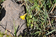
© 2020 Dean Wm. Taylor |
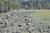
© 2020 Dean Wm. Taylor |
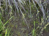
© 2021 Sarah Tona |
Taxon Summary:
Erythranthe inflatula, commonly known as ephemeral monkeyflower, is a annual herb in the Phrymaceae that is found in California and elsewhere. It occurs within Great Basin scrub, Lower montane coniferous forest, and Pinyon and juniper woodland, growing at elevations from 1250 to 1740 meters. Erythranthe inflatula is ranked 1B.2, Plants Rare, Threatened or Endangered in California and Elsewhere; Moderately threatened in California.|
Scientific Name: Erythranthe inflatula (Suksd.) G.L. Nesom |
||
|
Common Name: ephemeral monkeyflower |
||
| Family: | Phrymaceae | |
| Element Code: | PDSCR1B370 | |
| USDA Plants Symbol: | ||
|
Synonyms/Other Names: |
||
| Name Status: |
JEF, FNA, POWO, IPNI, Tropicos |
|
| CA Rare Plant Rank: | 1B.2 |
| Fed List: | None |
| State List: | None |
| Global Rank: | G3 |
|
State Rank: |
S2 |
| Other Status: | BLM_S; USFS_S |
|
CRPR Changes: |
|
| Add Date: | 2001-01-01 |
| Date Edited: | 2025-10-29 |
| Lifeform: annual herb | ||||||||||||||
Blooming Period: May-Aug
|
||||||||||||||
|
Elevation:
1250 - 1740 meters 4100 - 5710 feet |
||||||||||||||
General Habitats:
|
||||||||||||||
| Microhabitat Details: | ||||||||||||||
Microhabitat:
|
||||||||||||||
|
Notes: Possibly threatened by trampling and hydrological alterations. On review list in ID, and candidate for state listing in OR. Similar to E. breviflora; possibly a hybrid between E. breviflora and E. latidens. See Great Basin Naturalist 55(3):250 (1995) for original description, Phytoneuron 2012-39:1-60 (2012) for revised nomenclature, and Phytoneuron 2012-41:1-36 (2012) for taxonomic treatment. |
|
|
Threats: |
|
|
Taxonomy: |
|
| Threat List Total: | 6 | |
| Total EOs | % of EOs | |
| EOs with Threat Listed: | 15 | 58 % |
| THREAT LIST: | ||
|---|---|---|
| Grazing | 11 | 42% |
| Foot traffic/trampling | 7 | 26% |
| Road/trail construction/maint. | 2 | 7% |
| Insufficient population/stand size | 1 | 3% |
| Non-native plant impacts | 1 | 3% |
| Recreational use (non-ORV) | 1 | 3% |
| Total Occurrences: | 26 | ||||
| Element Occurrence Ranks: | |||||
|---|---|---|---|---|---|
| A | B | C | D | X | U |
| 2 | 9 | 3 | 5 | 1 | 6 |
| Occurrence Status: | |||||
|---|---|---|---|---|---|
| Historical >20 Years | 18 | ||||
| Recent <=20 Years | 8 | ||||
| Presence: | |||||
|---|---|---|---|---|---|
| Presumed Extant | 25 | ||||
| Possibly Extirpated | 1 | ||||
| Presumed Extirpated | 0 | ||||
| California Endemic: | |||||||||||||
| California Island: | |||||||||||||
|
States: Name (Code) California (CA), Idaho (ID), Nevada (NV)?, Oregon (OR) |
|||||||||||||
|
California Counties and Islands: Name (Code) Lassen (LAS), Modoc (MOD), Shasta (SHA), Siskiyou (SIS)* |
|||||||||||||
|
Quads: Name (Quad Code) Bray (4112168), Champs Flat (4012068), Corders Reservoir (4012172), Crank Mountain (4112142), Davis Creek (4112063), Donica Mtn. (4112132), Lane Reservoir (4112017), Lauer Reservoir (4112064), Letterbox Hill (4112018), Likely (4112025), Lookout (4112122), McDonald Peak (4012084), McGinty Reservoir (4112075), Perez (4112163), Poison Lake (4012162), Snowstorm Mtn. (4012063), South Mtn. (4112076), Spalding Tract (4012067), Spaulding Butte (4112152), Straylor Lake (4012171), Sugar Hill (4112073), Swains Hole (4012163) |
|||||||||||||
Notes:
|
|||||||||||||
 Presumed Extant
Click on quad for name. Hold Shift Key to use mouse scroll wheel