Taxon Details
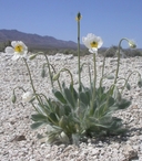
Arctomecon merriamii
white bear poppy
View Report Copy Link Calflora eFlora CCH CalPhotos iNaturalist

© 2010 James M. Andre |
© 2010 James M. Andre |

© 2010 James M. Andre |
Taxon Summary:
Arctomecon merriamii, commonly known as white bear poppy, is a perennial herb in the Papaveraceae that is found in California and elsewhere. It occurs within Chenopod scrub, and Mojavean desert scrub, growing at elevations from 490 to 1800 meters. Arctomecon merriamii is ranked 2B.2, Plants Rare, Threatened, or Endangered in California, But More Common Elsewhere; Moderately threatened in California.|
Scientific Name: Arctomecon merriamii Cov. |
||
|
Common Name: white bear poppy |
||
| Family: | Papaveraceae | |
| Element Code: | PDPAP02030 | |
| USDA Plants Symbol: | ARME2 | |
|
Synonyms/Other Names: |
||
| Name Status: |
JEF, FNA, POWO, IPNI, Tropicos |
|
| CA Rare Plant Rank: | 2B.2 |
| Fed List: | None |
| State List: | None |
| Global Rank: | G3 |
|
State Rank: |
S3 |
| Other Status: | SB_CalBG/RSABG |
|
CRPR Changes: |
|
| Add Date: | 1980-01-01 |
| Date Edited: | 2025-10-29 |
| Lifeform: perennial herb | ||||||||||||||
Blooming Period: (Mar)Apr-May
|
||||||||||||||
|
Elevation:
490 - 1800 meters 1610 - 5905 feet |
||||||||||||||
General Habitats:
|
||||||||||||||
| Microhabitat Details: | ||||||||||||||
Microhabitat:
|
||||||||||||||
|
Notes: Historical occurrences need field surveys; new occurrences found recently. On watch list in NV. See Mentzelia 3:2-5 (1977) for species account, Rhodora 95:209-212 (1993) for taxonomic treatment, and Madroño 44(2):151-169 (1997) for ecological information. |
|
|
Threats: Threatened by mining and vehicles. |
|
|
Taxonomy: |
|
| Threat List Total: | 10 | |
| Total EOs | % of EOs | |
| EOs with Threat Listed: | 10 | 21 % |
| THREAT LIST: | ||
|---|---|---|
| Foot traffic/trampling | 4 | 8% |
| Mining | 3 | 6% |
| Non-native animal impacts | 2 | 4% |
| ORV activity | 2 | 4% |
| Erosion/runoff | 2 | 4% |
| Road/trail construction/maint. | 2 | 4% |
| Other | 1 | 2% |
| Non-native plant impacts | 1 | 2% |
| Grazing | 1 | 2% |
| Military operations | 1 | 2% |
| Total Occurrences: | 47 | ||||
| Element Occurrence Ranks: | |||||
|---|---|---|---|---|---|
| A | B | C | D | X | U |
| 3 | 6 | 4 | 1 | 0 | 33 |
| Occurrence Status: | |||||
|---|---|---|---|---|---|
| Historical >20 Years | 30 | ||||
| Recent <=20 Years | 17 | ||||
| Presence: | |||||
|---|---|---|---|---|---|
| Presumed Extant | 47 | ||||
| Possibly Extirpated | 0 | ||||
| Presumed Extirpated | 0 | ||||
| California Endemic: | |||||||||||||
| California Island: | |||||||||||||
|
States: Name (Code) California (CA), Nevada (NV) |
|||||||||||||
|
California Counties and Islands: Name (Code) Inyo (INY), San Bernardino (SBD) |
|||||||||||||
|
Quads: Name (Quad Code) Chloride City (3611668), Clark Mtn. (3511555), Daylight Pass (3611678), Dry Mountain (3611785), East of Echo Canyon (3611645), Echo Canyon (3611646), Fall Canyon (3611772), Grotto Canyon (3611751), Ivanpah Lake (3511554), Mesquite Lake (3511565), North of Baker (3511641), North of Tecopa Pass (3511681), Resting Spring (3511682), Ryan (3611636), State Line Pass (3511564), Stewart Valley (3611622), Stovepipe Wells (3611752), Teakettle Junction (3611775), Tecopa (3511672), Tecopa Pass (3511671), Thimble Peak (3611771), Tin Mountain (3611784), Turquoise Mtn. (3511548), Twelvemile Spring (3611612), Ubehebe Crater (3711714), Ubehebe Peak (3611765), Wahguyhe Peak (3611781), White Top Mtn. (3611774), Wildrose Peak (3611731) |
|||||||||||||
Notes:
|
|||||||||||||
 Presumed Extant
Click on quad for name. Hold Shift Key to use mouse scroll wheel