Taxon Details
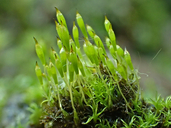
Bruchia bolanderi
Bolander's bruchia
View Report Copy Link Calflora eFlora CCH CalPhotos iNaturalist
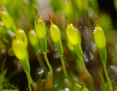
©2021 Scot Loring |

© 2016 Chris Wagner |
©2021 Scot Loring |
Taxon Summary:
Bruchia bolanderi, commonly known as Bolander's bruchia, is a moss in the Bruchianceae that is found in California and elsewhere. It occurs within Lower montane coniferous forest, Meadows and seeps, and Upper montane coniferous forest, growing at elevations from 1700 to 2800 meters. Bruchia bolanderi is ranked 4.2, Plants of Limited Distribution, A Watch List; Moderately threatened in California.|
Scientific Name: Bruchia bolanderi Lesq. |
||
|
Common Name: Bolander's bruchia |
||
| Family: | Bruchianceae | |
| Element Code: | NBMUS13010 | |
| USDA Plants Symbol: | BRBO2 | |
|
Synonyms/Other Names: |
||
| Name Status: |
JEF, FNA, POWO, IPNI, Tropicos |
|
| CA Rare Plant Rank: | 4.2 |
| Fed List: | None |
| State List: | None |
| Global Rank: | G3 |
|
State Rank: |
S3 |
| Other Status: | USFS_S |
|
CRPR Changes: |
|
| Add Date: | 2001-01-01 |
| Date Edited: | 2022-04-05 |
| Lifeform: moss | ||||||||||||||
Blooming Period:
|
||||||||||||||
|
Elevation:
1700 - 2800 meters 5580 - 9185 feet |
||||||||||||||
General Habitats:
|
||||||||||||||
| Microhabitat Details: damp soil | ||||||||||||||
|
Microhabitat:
|
||||||||||||||
| Threat List Total: | 6 | |
| Total EOs | % of EOs | |
| EOs with Threat Listed: | 6 | 21 % |
| THREAT LIST: | ||
|---|---|---|
| Other | 2 | 7% |
| Recreational use (non-ORV) | 2 | 7% |
| Road/trail construction/maint. | 1 | 3% |
| Foot traffic/trampling | 1 | 3% |
| Improper burning regime | 1 | 3% |
| Logging | 1 | 3% |
| Total Occurrences: | 28 | ||||
| Element Occurrence Ranks: | |||||
|---|---|---|---|---|---|
| A | B | C | D | X | U |
| 1 | 3 | 0 | 0 | 0 | 24 |
| Occurrence Status: | |||||
|---|---|---|---|---|---|
| Historical >20 Years | 25 | ||||
| Recent <=20 Years | 3 | ||||
| Presence: | |||||
|---|---|---|---|---|---|
| Presumed Extant | 28 | ||||
| Possibly Extirpated | 0 | ||||
| Presumed Extirpated | 0 | ||||
| California Endemic: | |||||||||||||
| California Island: | |||||||||||||
|
States: Name (Code) California (CA), Nevada (NV), Oregon (OR), Utah (UT) |
|||||||||||||
|
California Counties and Islands: Name (Code) El Dorado (ELD), Fresno (FRE), Madera (MAD), Mariposa (MPA), Mendocino (MEN), Modoc (MOD), Mono (MNO), Nevada (NEV), Placer (PLA), Plumas (PLU), Sierra (SIE), Siskiyou (SIS), Tulare (TUL), Tuolumne (TUO) |
|||||||||||||
|
Quads: Name (Quad Code) Mt. Rose (3911938), American House (3912161), Bucks Lake (3912182), Camp Nelson (3611825), Condrey Mtn. (4112288), Cooper Peak (3811927), Dogwood Peak (3912171), Dunderberg Peak (3811913), Echo Lake (3812071), El Capitan (3711966), Emigrant Lake (3811926), Freel Peak (3811978), Homewood (3912012), Hull Creek (3812011), Huntington Lake (3711922), Kern Peak (3611833), Little Shuteye Peak (3711944), Lodgepole (3611856), Mammoth Mtn. (3711961), Mariposa Grove (3711955), Meadow Valley (3912181), Mt. Bidwell (4112082), Mt. Fillmore (3912067), Mt. Harkness (4012143), Mt. Ingalls (3912086), Nelson Mtn. (3711911), Norden (3912033), North Palisade (3711815), Onion Valley (3912078), Pinecrest (3811928), Pyramid Peak (3812072), Reading Peak (4012144), Rockbound Valley (3812082), Shuteye Peak (3711934), Soda Springs (3912034), South Lake Tahoe (3811988), Squaw Dome (3711943), Tenaya Lake (3711974), Timber Knob (3711953), Tioga Pass (3711983), Tobias Peak (3511875), Willits (3912343) |
|||||||||||||
Notes:
|
|||||||||||||
 Presumed Extant
Click on quad for name. Hold Shift Key to use mouse scroll wheel