Taxon Details
Harpagonella palmeri
Palmer's grapplinghook
View Report Copy Link Calflora eFlora CCH CalPhotos iNaturalist
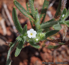
© 2015 Keir Morse |
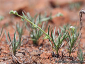
© 2015 Keir Morse |
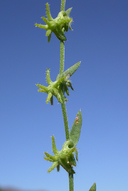
© 2009 Christopher L. Christie |
Taxon Summary:
Harpagonella palmeri, commonly known as Palmer's grapplinghook, is a annual herb in the Boraginaceae that is found in California and elsewhere. It occurs within Chaparral, Coastal scrub, and Valley and foothill grassland, growing at elevations from 20 to 955 meters. Harpagonella palmeri is ranked 4.2, Plants of Limited Distribution, A Watch List; Moderately threatened in California.|
Scientific Name: Harpagonella palmeri Gray |
||
|
Common Name: Palmer's grapplinghook |
||
| Family: | Boraginaceae | |
| Element Code: | PDBOR0H010 | |
| USDA Plants Symbol: | HAPA7 | |
|
Synonyms/Other Names: |
||
| Name Status: |
JEF, FNA, POWO, IPNI, Tropicos |
|
| CA Rare Plant Rank: | 4.2 |
| Fed List: | None |
| State List: | None |
| Global Rank: | G4 |
|
State Rank: |
S3 |
| Other Status: | SB_CalBG/RSABG; SB_CRES |
|
CRPR Changes: |
|
| Add Date: | 1980-01-01 |
| Date Edited: | 2025-10-29 |
| Lifeform: annual herb | ||||||||||||||
Blooming Period: Mar-May
|
||||||||||||||
|
Elevation:
20 - 955 meters 65 - 3135 feet |
||||||||||||||
General Habitats:
|
||||||||||||||
| Microhabitat Details: | ||||||||||||||
Microhabitat:
|
||||||||||||||
| Threat List Total: | 12 | |
| Total EOs | % of EOs | |
| EOs with Threat Listed: | 41 | 72 % |
| THREAT LIST: | ||
|---|---|---|
| Development | 32 | 56% |
| Road/trail construction/maint. | 8 | 14% |
| Agriculture | 5 | 8% |
| Non-native plant impacts | 4 | 7% |
| Grazing | 3 | 5% |
| Recreational use (non-ORV) | 3 | 5% |
| Mining | 2 | 3% |
| ORV activity | 2 | 3% |
| Foot traffic/trampling | 2 | 3% |
| Disking | 1 | 1% |
| Military operations | 1 | 1% |
| Surface water diversion | 1 | 1% |
| Total Occurrences: | 57 | ||||
| Element Occurrence Ranks: | |||||
|---|---|---|---|---|---|
| A | B | C | D | X | U |
| 5 | 11 | 5 | 1 | 5 | 30 |
| Occurrence Status: | |||||
|---|---|---|---|---|---|
| Historical >20 Years | 57 | ||||
| Recent <=20 Years | 0 | ||||
| Presence: | |||||
|---|---|---|---|---|---|
| Presumed Extant | 52 | ||||
| Possibly Extirpated | 5 | ||||
| Presumed Extirpated | 0 | ||||
| California Endemic: | |||||||||||||
| California Island: | |||||||||||||
|
States: Name (Code) Baja California (BA), California (CA) |
|||||||||||||
|
California Counties and Islands: Name (Code) Los Angeles (LAX), Orange (ORA), Riverside (RIV), San Diego (SDG) |
|||||||||||||
|
Quads: Name (Quad Code) Alberhill (3311764), Alpine (3211677), Bachelor Mtn. (3311751), Barrett Lake (3211666), Black Star Canyon (3311776), Bonsall (3311732), Cahuilla Mtn. (3311657), Canada Gobernadora (3311755), Dana Point (3311746), Del Mar (3211782), Dulzura (3211667), Earthquake Valley (3311614), El Cajon (3211678), El Cajon Mtn. (3211687), Encinitas (3311713), Imperial Beach (3211751), In-ko-pah Gorge (3211661), Jacumba (3211662), Jamul Mountains (3211668), La Jolla (3211772), La Mesa (3211771), Laguna Beach (3311757), Lake Elsinore (3311763), Lake Mathews (3311774), Las Pulgas Canyon (3311734), Margarita Peak (3311744), Mint Canyon (3411844), Morro Hill (3311733), Mt. Wilson (3411821), Murrieta (3311752), National City (3211761), Newhall (3411845), Oat Mountain (3411835), Otay Mesa (3211658), Pala (3311731), Pasadena (3411822), Pechanga (3311741), Potrero (3211655), Poway (3211781), Ramona (3311617), Ranchita (3311625), Rancho Santa Fe (3311712), Romoland (3311762), Sage (3311658), San Clemente (3311745), San Fernando (3411834), San Juan Capistrano (3311756), San Luis Rey (3311723), San Marcos (3311722), San Vicente Reservoir (3211688), Santa Catalina East (3311833), Santa Catalina North (3311844), Santa Catalina South (3311834), Santa Catalina West (3311845), Santa Susana (3411836), Steele Peak (3311773), Temecula (3311742), Vail Lake (3311648), Val Verde (3411846), Viejas Mountain (3211676), Warm Springs Mountain (3411855), Wildomar (3311753), Winchester (3311761) |
|||||||||||||
Notes:
|
|||||||||||||
 Presumed Extant
Click on quad for name. Hold Shift Key to use mouse scroll wheel