Taxon Details
Astragalus inversus
Susanville milk-vetch
View Report Copy Link Calflora eFlora CCH CalPhotos iNaturalist
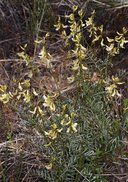
©2021 Steve Matson |
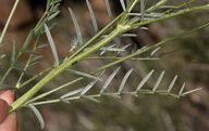
©2021 Steve Matson |

©2021 Steve Matson |
Taxon Summary:
Astragalus inversus, commonly known as Susanville milk-vetch, is a perennial herb in the Fabaceae that is found only in California. It occurs within Great Basin scrub, Lower montane coniferous forest, and Pinyon and juniper woodland, growing at elevations from 885 to 1850 meters. Astragalus inversus is ranked 4.3, Plants of Limited Distribution, A Watch List; Not very threatened in California.|
Scientific Name: Astragalus inversus Jones |
||
|
Common Name: Susanville milk-vetch |
||
| Family: | Fabaceae | |
| Element Code: | PDFAB0F4A0 | |
| USDA Plants Symbol: | ASIN7 | |
|
Synonyms/Other Names: |
||
| Name Status: |
JEF, FNA, POWO, IPNI, Tropicos |
|
| CA Rare Plant Rank: | 4.3 |
| Fed List: | None |
| State List: | None |
| Global Rank: | G4 |
|
State Rank: |
S4 |
| Other Status: | |
|
CRPR Changes: |
|
| Add Date: | 1974-01-01 |
| Date Edited: | 2026-05-15 |
| Lifeform: perennial herb | ||||||||||||||
Blooming Period: May-Sep
|
||||||||||||||
|
Elevation:
885 - 1850 meters 2905 - 6070 feet |
||||||||||||||
General Habitats:
|
||||||||||||||
| Microhabitat Details: | ||||||||||||||
Microhabitat:
|
||||||||||||||
| Threat List Total: | 0 | |
| Total EOs | % of EOs | |
| EOs with Threat Listed: | 0 | 0 % |
| THREAT LIST: | ||
|---|---|---|
| Total Occurrences: | 0 | ||||
| Element Occurrence Ranks: | |||||
|---|---|---|---|---|---|
| A | B | C | D | X | U |
| 0 | 0 | 0 | 0 | 0 | 0 |
| Occurrence Status: | |||||
|---|---|---|---|---|---|
| Historical >20 Years | 0 | ||||
| Recent <=20 Years | 0 | ||||
| Presence: | |||||
|---|---|---|---|---|---|
| Presumed Extant | 0 | ||||
| Possibly Extirpated | 0 | ||||
| Presumed Extirpated | 0 | ||||
| California Endemic: | |||||||||||||
| California Island: | |||||||||||||
|
States: Name (Code) California (CA) |
|||||||||||||
|
California Counties and Islands: Name (Code) Lassen (LAS), Modoc (MOD), Shasta (SHA), Siskiyou (SIS) |
|||||||||||||
|
Quads: Name (Quad Code) Antelope Mtn. (4012058), Bieber (4112112), Bogard Buttes (4012152), Boles Meadows East (4112067), Border Mtn. (4112144), Bullard Lake (4012078), Burney (4012186), Burney Falls (4112116), Burney Mtn. East (4012175), Burney Mtn. West (4012176), Cassel (4012185), Champs Flat (4012068), Corders Reservoir (4012172), Crank Mountain (4112142), Dana (4112115), Day (4112123), Donica Mtn. (4112132), East of Pondosa (4112125), Egg Lake (4112133), Harvey Mtn. (4012161), Hogback Ridge (4012184), Hollenbeck (4112143), Indian Spring Mtn. (4112135), Jellico (4012173), Johnstonville (4012045), Manzanita Lake (4012155), Old Station (4012164), Pine Creek Valley (4012151), Pittville (4112113), Poison Lake (4012162), Pondosa (4112126), Rimrock Lake (4112162), Roop Mountain (4012047), Snag Hill (4112146), Spalding Tract (4012067), Spaulding Butte (4112152), Straylor Lake (4012171), Susanville (4012046), Swains Hole (4012163), Timbered Crater (4112124), Viola (4012156), West of Kephart (4112154), West Prospect Peak (4012154), Whitehorse (4112134) |
|||||||||||||
Notes:
|
|||||||||||||
 Presumed Extant
Click on quad for name. Hold Shift Key to use mouse scroll wheel