Taxon Details
Grusonia parishii
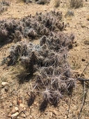
Parish's club-cholla
View Report Copy Link Calflora eFlora CCH CalPhotos iNaturalist

© 2012 James M. Andre |

© 2012 James M. Andre |
© 2018 Matt C. Berger |
Taxon Summary:
Grusonia parishii, commonly known as Parish's club-cholla, is a perennial stem in the Cactaceae that is found in California and elsewhere. It occurs within Joshua tree "woodland", Mojavean desert scrub, and Sonoran desert scrub, growing at elevations from 300 to 1524 meters. Grusonia parishii is ranked 2B.2, Plants Rare, Threatened, or Endangered in California, But More Common Elsewhere; Moderately threatened in California.|
Scientific Name: Grusonia parishii (Orcutt) Pinkava |
||
|
Common Name: Parish's club-cholla |
||
| Family: | Cactaceae | |
| Element Code: | PDCAC0D2H0 | |
| USDA Plants Symbol: | GRPA11 | |
|
Synonyms/Other Names: |
||
| Name Status: |
JEF, FNA, POWO, IPNI, Tropicos |
|
| CA Rare Plant Rank: | 2B.2 |
| Fed List: | None |
| State List: | None |
| Global Rank: | G3G4 |
|
State Rank: |
S2 |
| Other Status: | |
|
CRPR Changes: added to 2.3 on 2007-03-20 |
|
| Add Date: | 2007-03-20 |
| Date Edited: | 2025-10-29 |
| Lifeform: perennial stem | ||||||||||||||
Blooming Period: May-Jun(Jul)
|
||||||||||||||
|
Elevation:
300 - 1524 meters 985 - 5000 feet |
||||||||||||||
General Habitats:
|
||||||||||||||
| Microhabitat Details: | ||||||||||||||
Microhabitat:
|
||||||||||||||
| Threat List Total: | 10 | |
| Total EOs | % of EOs | |
| EOs with Threat Listed: | 26 | 58 % |
| THREAT LIST: | ||
|---|---|---|
| ORV activity | 15 | 33% |
| Development | 12 | 26% |
| Mining | 7 | 15% |
| Non-native animal impacts | 4 | 8% |
| Grazing | 4 | 8% |
| Recreational use (non-ORV) | 4 | 8% |
| Vandalism/dumping/litter | 2 | 4% |
| Road/trail construction/maint. | 1 | 2% |
| Other | 1 | 2% |
| Over-collecting/poaching | 1 | 2% |
| Total Occurrences: | 45 | ||||
| Element Occurrence Ranks: | |||||
|---|---|---|---|---|---|
| A | B | C | D | X | U |
| 4 | 10 | 7 | 6 | 0 | 18 |
| Occurrence Status: | |||||
|---|---|---|---|---|---|
| Historical >20 Years | 10 | ||||
| Recent <=20 Years | 35 | ||||
| Presence: | |||||
|---|---|---|---|---|---|
| Presumed Extant | 45 | ||||
| Possibly Extirpated | 0 | ||||
| Presumed Extirpated | 0 | ||||
| California Endemic: | |||||||||||||
| California Island: | |||||||||||||
|
States: Name (Code) Arizona (AZ), California (CA), Nevada (NV), Texas (TX)? |
|||||||||||||
|
California Counties and Islands: Name (Code) Riverside (RIV), San Bernardino (SBD) |
|||||||||||||
|
Quads: Name (Quad Code) Buzzard Spring (3311575), Castle Peaks (3511532), Cima Dome (3511535), Crescent Peak (3511542), Grotto Hills (3511522), Hackberry Mountain (3511512), Hart Peak (3511531), Indian Cove (3411612), Ivanpah (3511533), Ivanpah Lake (3511554), Joshua Tree North (3411623), Malapai Hill (3311681), Mescal Range (3511545), Mesquite Lake (3511565), Mineral Hill (3511544), Queen Mtn. (3411611), State Line Pass (3511564), Valley Wells (3511546) |
|||||||||||||
Notes:
|
|||||||||||||
 Presumed Extant
Click on quad for name. Hold Shift Key to use mouse scroll wheel