Taxon Details
Amsinckia douglasiana
Douglas' fiddleneck
View Report Copy Link Calflora eFlora CCH CalPhotos iNaturalist
Taxon Summary:
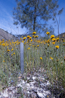
Amsinckia douglasiana, commonly known as Douglas' fiddleneck, is a annual herb in the Boraginaceae that is found only in California. It occurs within Cismontane woodland, and Valley and foothill grassland, growing at elevations from 0 to 1950 meters. Amsinckia douglasiana is ranked 4.2, Plants of Limited Distribution, A Watch List; Moderately threatened in California.|
Scientific Name: Amsinckia douglasiana A. DC. |
||
|
Common Name: Douglas' fiddleneck |
||
| Family: | Boraginaceae | |
| Element Code: | PDBOR01010 | |
| USDA Plants Symbol: | AMDO | |
|
Synonyms/Other Names: |
||
| Name Status: |
JEF, FNA, POWO, IPNI, Tropicos |
|
| CA Rare Plant Rank: | 4.2 |
| Fed List: | None |
| State List: | None |
| Global Rank: | G4 |
|
State Rank: |
S4 |
| Other Status: | SB_CalBG/RSABG; SB_SBBG |
|
CRPR Changes: added to 4.2 on 2007-08-20 |
|
| Add Date: | 2007-08-20 |
| Date Edited: | 2025-10-29 |
| Lifeform: annual herb | ||||||||||||||
Blooming Period: Mar-May
|
||||||||||||||
|
Elevation:
0 - 1950 meters 0 - 6400 feet |
||||||||||||||
General Habitats:
|
||||||||||||||
| Microhabitat Details: Monterey shale | ||||||||||||||
Microhabitat:
|
||||||||||||||
| Threat List Total: | 0 | |
| Total EOs | % of EOs | |
| EOs with Threat Listed: | 0 | 0 % |
| THREAT LIST: | ||
|---|---|---|
| Total Occurrences: | 0 | ||||
| Element Occurrence Ranks: | |||||
|---|---|---|---|---|---|
| A | B | C | D | X | U |
| 0 | 0 | 0 | 0 | 0 | 0 |
| Occurrence Status: | |||||
|---|---|---|---|---|---|
| Historical >20 Years | 0 | ||||
| Recent <=20 Years | 0 | ||||
| Presence: | |||||
|---|---|---|---|---|---|
| Presumed Extant | 0 | ||||
| Possibly Extirpated | 0 | ||||
| Presumed Extirpated | 0 | ||||
| California Endemic: | |||||||||||||
| California Island: | |||||||||||||
|
States: Name (Code) California (CA) |
|||||||||||||
|
California Counties and Islands: Name (Code) Kern (KRN), Monterey (MNT), Riverside (RIV), San Benito (SBT), San Luis Obispo (SLO), Santa Barbara (SBA), Ventura (VEN) |
|||||||||||||
|
Quads: Name (Quad Code) Adelaida (3512067), Bena (3511836), Bradley (3512077), Bryson (3512171), Burnett Peak (3512172), California Valley (3512031), Camatta Ranch (3512043), Chimineas Ranch (3511928), Cholame Valley (3512073), Cosio Knob (3612112), Creston (3512055), Dos Pueblos Canyon (3411948), Eagle Rest Peak (3411982), Espinosa Canyon (3612111), Figueroa Mtn. (3411968)?, Gonzales (3612154), Hames Valley (3512088), Jolon (3512182), Keene (3511825), La Panza (3512032), La Panza NE (3512041), La Panza Ranch (3512042), Little Pine Mtn. (3411956), Lonoak (3612038), Miranda Pine Mtn. (3512011), Mount Johnson (3612153), Murrieta (3311752), Oceano (3512015), Old Man Mountain (3411954), Orchard Peak (3512062), Paicines (3612163), Paso Robles (3512066), Rancho Nuevo Creek (3411964), Reyes Peak (3411963)?, Salisbury Potrero (3411976), San Lucas (3612121)?, Sisquoc (3412073), Sycamore Flat (3612134), Taylor Canyon (3511918), Templeton (3512056), Tierra Redonda Mountain (3512078), Valleton (3512086), Wheeler Springs (3411953), Williams Hill (3512181), Wilson Corner (3512044), Zaca Creek (3412062) |
|||||||||||||
Notes:
|
|||||||||||||
 Presumed Extant
Click on quad for name. Hold Shift Key to use mouse scroll wheel


