Taxon Details
Brodiaea orcuttii
Orcutt's brodiaea
View Report Copy Link Calflora eFlora CCH CalPhotos iNaturalist
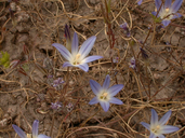
© 2001 Ellen Friedman & Ted Dunning |
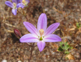
© 2010 Andrew Borcher |
Taxon Summary:
Brodiaea orcuttii, commonly known as Orcutt's brodiaea, is a perennial bulbiferous herb in the Themidaceae that is found only in California. It occurs within Chaparral, Cismontane woodland, Closed-cone coniferous forest, Meadows and seeps, Valley and foothill grassland, and Vernal pools, growing at elevations from 30 to 1692 meters. Brodiaea orcuttii is ranked 1B.1, Plants Rare, Threatened or Endangered in California and Elsewhere; Seriously threatened in California.|
Scientific Name: Brodiaea orcuttii (Greene) Baker |
||
|
Common Name: Orcutt's brodiaea |
||
| Family: | Themidaceae | |
| Element Code: | PMLIL0C0B0 | |
| USDA Plants Symbol: | BROR | |
|
Synonyms/Other Names: |
||
| Name Status: |
JEF, FNA, POWO, IPNI, Tropicos |
|
| CA Rare Plant Rank: | 1B.1 |
| Fed List: | None |
| State List: | None |
| Global Rank: | G2 |
|
State Rank: |
S2 |
| Other Status: | BLM_S; SB_CRES; USFS_S |
|
CRPR Changes: |
|
| Add Date: | 1974-01-01 |
| Date Edited: | 2025-10-29 |
| Lifeform: perennial bulbiferous herb | ||||||||||||||
Blooming Period: May-Jul
|
||||||||||||||
|
Elevation:
30 - 1692 meters 100 - 5550 feet |
||||||||||||||
General Habitats:
|
||||||||||||||
| Microhabitat Details: | ||||||||||||||
Microhabitat:
|
||||||||||||||
|
Notes: Historical occurrences need field surveys. |
|
|
Threats: Seriously threatened by development, foot traffic, grazing, non-native plants, military activities, vehicles, road construction, road maintenance, and dumping. |
|
|
Taxonomy: Hybridizes with B. filifolia. See Bulletin of the California Academy of Sciences 2:138 (1886) for original description, and University of California Publications in Botany 60:59-61 (1971) for taxonomic treatment. |
|
| Threat List Total: | 17 | |
| Total EOs | % of EOs | |
| EOs with Threat Listed: | 77 | 54 % |
| THREAT LIST: | ||
|---|---|---|
| Development | 38 | 26% |
| Non-native plant impacts | 28 | 19% |
| Road/trail construction/maint. | 26 | 18% |
| Foot traffic/trampling | 20 | 14% |
| ORV activity | 19 | 13% |
| Vandalism/dumping/litter | 17 | 11% |
| Other | 10 | 7% |
| Erosion/runoff | 7 | 4% |
| Altered flood/tidal/hydrologic regime | 7 | 4% |
| Improper burning regime | 5 | 3% |
| Recreational use (non-ORV) | 5 | 3% |
| Wood cutting or brush clearing | 4 | 2% |
| Military operations | 3 | 2% |
| Grazing | 3 | 2% |
| Dam/Inundation | 1 | 0% |
| Surface water diversion | 1 | 0% |
| Agriculture | 1 | 0% |
| Total Occurrences: | 142 | ||||
| Element Occurrence Ranks: | |||||
|---|---|---|---|---|---|
| A | B | C | D | X | U |
| 5 | 12 | 8 | 12 | 16 | 89 |
| Occurrence Status: | |||||
|---|---|---|---|---|---|
| Historical >20 Years | 86 | ||||
| Recent <=20 Years | 56 | ||||
| Presence: | |||||
|---|---|---|---|---|---|
| Presumed Extant | 126 | ||||
| Possibly Extirpated | 7 | ||||
| Presumed Extirpated | 9 | ||||
| California Endemic: | |||||||||||||
| California Island: | |||||||||||||
|
States: Name (Code) California (CA) |
|||||||||||||
|
California Counties and Islands: Name (Code) Riverside (RIV), San Diego (SDG) |
|||||||||||||
|
Quads: Name (Quad Code) Alpine (3211677), Barrett Lake (3211666), Boucher Hill (3311638), Cuyamaca Peak (3211685), Del Mar (3211782), Descanso (3211675), Dulzura (3211667), El Cajon (3211678), El Cajon Mtn. (3211687), Encinitas (3311713), Jamul Mountains (3211668), Julian (3311615), La Jolla (3211772), La Mesa (3211771), Margarita Peak (3311744), Mesa Grande (3311627), Morena Reservoir (3211665), Morro Hill (3311733), Mount Laguna (3211674), Otay Mesa (3211658), Otay Mountain (3211657), Pala (3311731), Palomar Observatory (3311637), Pechanga (3311741), Poway (3211781), Ramona (3311617), Rancho Santa Fe (3311712), Rodriquez Mtn. (3311628), San Marcos (3311722), San Pasqual (3311618), San Vicente Reservoir (3211688), Santa Ysabel (3311616), Tecate (3211656), Temecula (3311742), Valley Center (3311721), Viejas Mountain (3211676), Warner Springs (3311636) |
|||||||||||||
Notes:
|
|||||||||||||
 Presumed Extant
Click on quad for name. Hold Shift Key to use mouse scroll wheel