Taxon Details
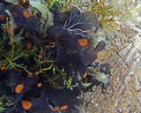
Peltigera gowardii
western waterfan lichen
View Report Copy Link Calflora eFlora CCH CalPhotos iNaturalist
© 2021 Scot Loring |

©2014 Eric B. Peterson |

© 2018 Julie Kierstead Nelson |
Taxon Summary:
Peltigera gowardii, commonly known as western waterfan lichen, is a foliose lichen (aquatic) in the Peltigeraceae that is found in California and elsewhere. It occurs within Riparian forest, growing at elevations from 1065 to 2620 meters. Peltigera gowardii is ranked 4.2, Plants of Limited Distribution, A Watch List; Moderately threatened in California.|
Scientific Name: Peltigera gowardii Lendemer & H. O’Brien |
||
|
Common Name: western waterfan lichen |
||
| Family: | Peltigeraceae | |
| Element Code: | NLVER00460 | |
| USDA Plants Symbol: | ||
|
Synonyms/Other Names: |
||
| Name Status: |
JEF, FNA, POWO, IPNI, Tropicos |
|
| CA Rare Plant Rank: | 4.2 |
| Fed List: | None |
| State List: | None |
| Global Rank: | G3G4 |
|
State Rank: |
S3 |
| Other Status: | USFS_S |
|
CRPR Changes: |
|
| Add Date: | 2014-03-01 |
| Date Edited: | 2025-04-01 |
| Lifeform: foliose lichen (aquatic) | ||||||||||||||
Blooming Period:
|
||||||||||||||
|
Elevation:
1065 - 2620 meters 3495 - 8595 feet |
||||||||||||||
General Habitats:
|
||||||||||||||
| Microhabitat Details: On rocks in cold water creeks with little or no sediment or disturbance | ||||||||||||||
|
Microhabitat:
|
||||||||||||||
| Threat List Total: | 8 | |
| Total EOs | % of EOs | |
| EOs with Threat Listed: | 14 | 54 % |
| THREAT LIST: | ||
|---|---|---|
| Altered flood/tidal/hydrologic regime | 7 | 26% |
| Logging | 3 | 11% |
| ORV activity | 2 | 7% |
| Recreational use (non-ORV) | 2 | 7% |
| Surface water diversion | 1 | 3% |
| Other | 1 | 3% |
| Dam/Inundation | 1 | 3% |
| Erosion/runoff | 1 | 3% |
| Total Occurrences: | 26 | ||||
| Element Occurrence Ranks: | |||||
|---|---|---|---|---|---|
| A | B | C | D | X | U |
| 8 | 8 | 1 | 0 | 0 | 9 |
| Occurrence Status: | |||||
|---|---|---|---|---|---|
| Historical >20 Years | 9 | ||||
| Recent <=20 Years | 17 | ||||
| Presence: | |||||
|---|---|---|---|---|---|
| Presumed Extant | 26 | ||||
| Possibly Extirpated | 0 | ||||
| Presumed Extirpated | 0 | ||||
| California Endemic: | |||||||||||||
| California Island: | |||||||||||||
|
States: Name (Code) California (CA), Georgia (GA), Maine (ME), Massachusetts (MA), Montana (MT), New Hampshire (NH), New Jersey (NJ), New York (NY), North Carolina (NC), Oregon (OR), Pennsylvania (PA), Tennessee (TN), Vermont (VT), Virginia (VA), Washington (WA) |
|||||||||||||
|
California Counties and Islands: Name (Code) Amador (AMA), Butte (BUT), Calaveras (CAL), El Dorado (ELD), Fresno (FRE), Madera (MAD), Mariposa (MPA), Mono (MNO), Placer (PLA), Plumas (PLU), Sierra (SIE), Siskiyou (SIS), Trinity (TRI), Tulare (TUL), Tuolumne (TUO), Yuba (YUB) |
|||||||||||||
|
Quads: Name (Quad Code) American House (3912161), Boards Crossing (3812032), Calaveras Dome (3812042), Caldor (3812054), Camp Nelson (3611825), Cascade (3912162), Crandall Peak (3812022), Dinkey Creek (3711912), Dogwood Peak (3912171), Duckwall Mtn. (3712081), Echo Lake (3812071), Emerald Bay (3812081), Etna (4112248), Fish Camp (3711946), Forest Glen (4012333), Freel Peak (3811978), Haypress Valley (3912055), Homewood (3912012), Hull Creek (3812011), Huntington Lake (3711922), Kimshew Point (3912184), La Porte (3912068), Leek Spring Hill (3812063), Mammoth Pool Dam (3711933), Meeks Bay (3912011), Mount Dana (3711982), Muir Grove (3611867), Patterson Mtn. (3611981), Peddler Hill (3812053), Pollock Pines (3812075), Pulga (3912174), Red Cinder (4012142), Robbs Peak (3812084), Rough Spur (3611888), Sentinel Peak (3611815), Shuteye Peak (3711934), Soapstone Hill (3912173), Stanislaus (3812023), Strawberry (3812021), Strawberry Valley (3912151), Westville (3912026), White Chief Mtn. (3711945) |
|||||||||||||
Notes:
|
|||||||||||||
 Presumed Extant
Click on quad for name. Hold Shift Key to use mouse scroll wheel