Taxon Details
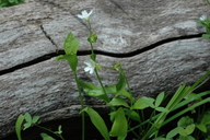
Claytonia palustris
marsh claytonia
View Report Copy Link Calflora eFlora CCH CalPhotos iNaturalist
©2006 Dean Wm. Taylor, Ph.D. |

©2017 Chris Winchell |

©2018 Sierra Pacific Industries |
Taxon Summary:
Claytonia palustris, commonly known as marsh claytonia, is a perennial herb in the Montiaceae that is found only in California. It occurs within Marshes and swamps, Meadows and seeps (mesic), and Upper montane coniferous forest, growing at elevations from 1000 to 2500 meters. Claytonia palustris is ranked 4.3, Plants of Limited Distribution, A Watch List; Not very threatened in California.|
Scientific Name: Claytonia palustris Swanson & Kelley |
||
|
Common Name: marsh claytonia |
||
| Family: | Montiaceae | |
| Element Code: | PDPOR030S0 | |
| USDA Plants Symbol: | CLPA10 | |
|
Synonyms/Other Names: |
||
| Name Status: |
JEF, FNA, POWO, IPNI, Tropicos |
|
| CA Rare Plant Rank: | 4.3 |
| Fed List: | None |
| State List: | None |
| Global Rank: | G4 |
|
State Rank: |
S4 |
| Other Status: | |
|
CRPR Changes: |
|
| Add Date: | 1988-01-01 |
| Date Edited: | 2025-10-29 |
| Lifeform: perennial herb | ||||||||||||||
Blooming Period: May-Oct
|
||||||||||||||
|
Elevation:
1000 - 2500 meters 3280 - 8205 feet |
||||||||||||||
General Habitats:
|
||||||||||||||
| Microhabitat Details: | ||||||||||||||
|
Microhabitat:
|
||||||||||||||
| Threat List Total: | 0 | |
| Total EOs | % of EOs | |
| EOs with Threat Listed: | 0 | 0 % |
| THREAT LIST: | ||
|---|---|---|
| Total Occurrences: | 0 | ||||
| Element Occurrence Ranks: | |||||
|---|---|---|---|---|---|
| A | B | C | D | X | U |
| 0 | 0 | 0 | 0 | 0 | 0 |
| Occurrence Status: | |||||
|---|---|---|---|---|---|
| Historical >20 Years | 0 | ||||
| Recent <=20 Years | 0 | ||||
| Presence: | |||||
|---|---|---|---|---|---|
| Presumed Extant | 0 | ||||
| Possibly Extirpated | 0 | ||||
| Presumed Extirpated | 0 | ||||
| California Endemic: | |||||||||||||
| California Island: | |||||||||||||
|
States: Name (Code) California (CA) |
|||||||||||||
|
California Counties and Islands: Name (Code) Butte (BUT), El Dorado (ELD), Fresno (FRE), Lassen (LAS), Plumas (PLU), Shasta (SHA), Siskiyou (SIS), Tehama (TEH), Trinity (TRI), Tulare (TUL) |
|||||||||||||
|
Quads: Name (Quad Code) Ash Creek Butte (4112241), Barkley Mtn. (4012126), Blue Nose Mtn. (3912077), Butte Meadows (4012115), Camp Nelson (3611825), Canyondam (4012121), Casa Vieja Meadows (3611823), Cedar Grove (3611876), Chico (3912167), Childs Meadows (4012134), City of Mount Shasta (4112233), Cohasset (3912186), Crescent Mills (4012018), Denny (4012384), Dinkey Creek (3711912), Dunsmuir (4112223), Durrwood Creek (3611814), Etna (4112248), Giant Forest (3611857), Hamlin Canyon (3912166), Hockett Peak (3611824), Humboldt Peak (4012124), Humbug Valley (4012123), Johnsondale (3511885), Jonesville (4012114), Kern Peak (3611833), Kyburz (3812073), Lassen Peak (4012145), Lodgepole (3611856), McCloud (4112232), Meadow Valley (3912181), Mineral (4012135), Mineral King (3611845), North Yolla Bolly (4012228), Onion Butte (4012125), Paradise West (3912176), Quincy (3912088), Quincy School (3511878), Riverton (3812074), Robbs Peak (3812084), Sentinel Peak (3611815), Shaver Lake (3711913), Silver City (3611846), Snowstorm Mtn. (4012063), Sphinx Lakes (3611865), Spring Garden (3912087), Tangle Blue Lake (4112226), Triple Divide Peak (3611855), Twain (4012111) |
|||||||||||||
Notes:
|
|||||||||||||
 Presumed Extant
Click on quad for name. Hold Shift Key to use mouse scroll wheel