Taxon Details
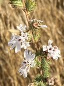
Calycadenia spicata
spicate calycadenia
View Report Copy Link Calflora eFlora CCH CalPhotos iNaturalist
© 2023 Christopher Bronny |

© 2023 Christopher Bronny |
© 2023 Christopher Bronny |
Taxon Summary:
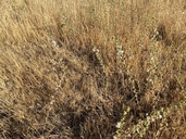
Calycadenia spicata, commonly known as spicate calycadenia, is a annual herb in the Asteraceae that is found only in California. It occurs within Cismontane woodland, and Valley and foothill grassland, growing at elevations from 40 to 1400 meters. Calycadenia spicata is ranked 1B.3, Plants Rare, Threatened or Endangered in California and Elsewhere; Not very threatened in California.|
Scientific Name: Calycadenia spicata (Greene) Greene |
||
|
Common Name: spicate calycadenia |
||
| Family: | Asteraceae | |
| Element Code: | PDAST1P090 | |
| USDA Plants Symbol: | CASP2 | |
|
Synonyms/Other Names: |
||
| Name Status: |
JEF, FNA, POWO, IPNI, Tropicos |
|
| CA Rare Plant Rank: | 1B.3 |
| Fed List: | None |
| State List: | None |
| Global Rank: | G3? |
|
State Rank: |
S3 |
| Other Status: | |
|
CRPR Changes: added to 1B.3 on 2023-05-17 |
|
| Add Date: | 2023-04-05 |
| Date Edited: | 2025-10-29 |
| Lifeform: annual herb | ||||||||||||||
Blooming Period: May-Sep
|
||||||||||||||
|
Elevation:
40 - 1400 meters 130 - 4595 feet |
||||||||||||||
General Habitats:
|
||||||||||||||
| Microhabitat Details: | ||||||||||||||
Microhabitat:
|
||||||||||||||
|
Notes: Formerly widespread but local at eastern edge of Central Valley and adjacent Sierra Nevada foothills. |
|
|
Threats: Possibly threatened by vehicles, development, habitat loss, inappropriate grazing, alteration of fire regimes, non-native plants, and pollution (nitrogen deposition). |
|
|
Taxonomy: A distinctive species with stems simple or branched only above the middle, peduncular bracts with only a single tack-shaped gland at the tip, phyllaries and paleae with many tack-shaped glands, and corolla white turning red with age. |
|
| Threat List Total: | 0 | |
| Total EOs | % of EOs | |
| EOs with Threat Listed: | 0 | % |
| THREAT LIST: | ||
|---|---|---|
|
|
||
| Total Occurrences: | 41 | ||||
| Element Occurrence Ranks: | |||||
|---|---|---|---|---|---|
| A | B | C | D | X | U |
| 0 | 4 | 0 | 0 | 0 | 37 |
| Occurrence Status: | |||||
|---|---|---|---|---|---|
| Historical >20 Years | 30 | ||||
| Recent <=20 Years | 11 | ||||
| Presence: | |||||
|---|---|---|---|---|---|
| Presumed Extant | 41 | ||||
| Possibly Extirpated | 0 | ||||
| Presumed Extirpated | 0 | ||||
| California Endemic: | |||||||||||||
| California Island: | |||||||||||||
|
States: Name (Code) California (CA) |
|||||||||||||
|
California Counties and Islands: Name (Code) Amador (AMA), Butte (BUT), Calaveras (CAL), El Dorado (ELD), Fresno (FRE), Kern (KRN), Nevada (NEV), Placer (PLA), Sacramento (SAC), San Joaquin (SJQ), Stanislaus (STA), Tulare (TUL), Tuolumne (TUO), Yuba (YUB) |
|||||||||||||
|
Quads: Name (Quad Code) Auberry (3711914), Biggs (3912146), Buffalo Creek (3812152), Camp Far West (3912113), Carbondale (3812141), Clarksville (3812161), Clay (3812132), Cooperstown (3712065), Farmington (3712088), Folsom (3812162), Giant Forest (3611857), Glennville (3511866), Goose Creek (3812131), Grass Valley (3912121), Hamlin Canyon (3912166), Honcut (3912135), Ione (3812038), Irish Hill (3812048), Jenny Lind (3812017), Keystone (3712075), Knights Ferry (3712076), La Grange (3712064), Lake Isabella South (3511854), Lincoln (3812183), Loma Rica (3912134), Millerton Lake East (3711915), Oroville (3912155), Palermo (3912145), Pine Mountain (3511857), Shadequarter Mtn. (3611858), Shippee (3912156), Valley Springs (3812027), Wallace (3812028) |
|||||||||||||
Notes:
|
|||||||||||||
 Presumed Extant
Click on quad for name. Hold Shift Key to use mouse scroll wheel