Taxon Details
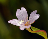
Epilobium oreganum
Oregon fireweed
View Report Copy Link Calflora eFlora CCH CalPhotos iNaturalist
© 2015 Steve Matson |

© 2021 Scot Loring |

©2013 Sierra Pacific Industries |
Taxon Summary:
Epilobium oreganum, commonly known as Oregon fireweed, is a perennial herb in the Onagraceae that is found in California and elsewhere. It occurs within Bogs and fens, Lower montane coniferous forest, Meadows and seeps, and Upper montane coniferous forest, growing at elevations from 500 to 2240 meters. Epilobium oreganum is ranked 1B.2, Plants Rare, Threatened or Endangered in California and Elsewhere; Moderately threatened in California.|
Scientific Name: Epilobium oreganum Greene |
||
|
Common Name: Oregon fireweed |
||
| Family: | Onagraceae | |
| Element Code: | PDONA060P0 | |
| USDA Plants Symbol: | EPOR | |
|
Synonyms/Other Names: |
||
| Name Status: |
JEF, FNA, POWO, IPNI, Tropicos |
|
| CA Rare Plant Rank: | 1B.2 |
| Fed List: | None |
| State List: | None |
| Global Rank: | G3 |
|
State Rank: |
S2 |
| Other Status: | BLM_S; SB_CalBG/RSABG; USFS_S |
|
CRPR Changes: |
|
| Add Date: | 1980-01-01 |
| Date Edited: | 2026-03-06 |
| Lifeform: perennial herb | ||||||||||||||
Blooming Period: Jun-Sep
|
||||||||||||||
|
Elevation:
500 - 2240 meters 1640 - 7350 feet |
||||||||||||||
General Habitats:
|
||||||||||||||
| Microhabitat Details: | ||||||||||||||
Microhabitat:
|
||||||||||||||
|
Notes: Unable to confirm many historical occurrences on Shasta-Trinity NF; is it more common elsewhere? Threatened by logging and grazing. Known from fewer than 1000 plants at about twenty localities in OR, where candidate for state listing. See Pittonia 1:255 (1888) for original description. |
|
|
Threats: |
|
|
Taxonomy: |
|
| Threat List Total: | 6 | |
| Total EOs | % of EOs | |
| EOs with Threat Listed: | 17 | 28 % |
| THREAT LIST: | ||
|---|---|---|
| Road/trail construction/maint. | 7 | 11% |
| Altered flood/tidal/hydrologic regime | 6 | 9% |
| Grazing | 6 | 9% |
| Foot traffic/trampling | 3 | 4% |
| Recreational use (non-ORV) | 2 | 3% |
| Other | 1 | 1% |
| Total Occurrences: | 61 | ||||
| Element Occurrence Ranks: | |||||
|---|---|---|---|---|---|
| A | B | C | D | X | U |
| 4 | 19 | 2 | 0 | 0 | 36 |
| Occurrence Status: | |||||
|---|---|---|---|---|---|
| Historical >20 Years | 36 | ||||
| Recent <=20 Years | 25 | ||||
| Presence: | |||||
|---|---|---|---|---|---|
| Presumed Extant | 61 | ||||
| Possibly Extirpated | 0 | ||||
| Presumed Extirpated | 0 | ||||
| California Endemic: | |||||||||||||
| California Island: | |||||||||||||
|
States: Name (Code) California (CA), Oregon (OR) |
|||||||||||||
|
California Counties and Islands: Name (Code) Del Norte (DNT), Glenn (GLE), Humboldt (HUM), Mendocino (MEN), Shasta (SHA), Siskiyou (SIS), Tehama (TEH), Trinity (TRI) |
|||||||||||||
|
Quads: Name (Quad Code) O'brien -rename- (4212316), Takilma (4212315), Board Camp Mtn. (4012366), Broken Rib Mtn. (4112386), Buck Rock (3912288), Buckhorn Bally (4112287), Caribou Lake (4112218), Chicken Hawk Hill (4112214), Chimney Rock (4112356), City of Mount Shasta (4112233), Covington Mill (4012287), Denny (4012384), Dunsmuir (4112223), Forest Glen (4012333), Grouse Mtn. (4012376), Hoosimbim Mtn. (4012258), Hyampom Mtn. (4012364), Maple Creek (4012377), Marble Mountain (4112352), Mendocino Pass (3912278), Mount Eddy (4112234), Naufus Creek (4012343), Plaskett Meadows (3912267), Polar Bear Mtn. (4112385), Pony Buck Peak (4012331), Rush Creek Lakes (4012278), Siligo Peak (4012288), Sims Mountain (4012365), Smoky Creek (4012332), Somes Bar (4112344), Tangle Blue Lake (4112226), Tish Tang Point (4112315), Trinity Center (4012286), Trinity Dam (4012277), Trinity Mtn. (4112314), Ukonom Mtn. (4112354), Whisky Bill Peak (4112215), Wildwood (4012341), Ycatapom Peak (4112217) |
|||||||||||||
Notes:
|
|||||||||||||
 Presumed Extant
Click on quad for name. Hold Shift Key to use mouse scroll wheel