Taxon Details
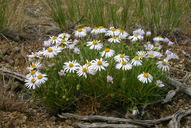
Erigeron elegantulus
volcanic daisy
View Report Copy Link Calflora eFlora CCH CalPhotos iNaturalist
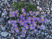
©2018 Jason Matthias Mills |

©2008 Sean B. Smith |
©2008 Christopher L. Christie |
Taxon Summary:
Erigeron elegantulus, commonly known as volcanic daisy, is a perennial herb in the Asteraceae that is found in California and elsewhere. It occurs within Alpine boulder and rock field, Great Basin scrub, Pinyon and juniper woodland, Subalpine coniferous forest, and Upper montane coniferous forest, growing at elevations from 1000 to 2665 meters. Erigeron elegantulus is ranked 4.3, Plants of Limited Distribution, A Watch List; Not very threatened in California.|
Scientific Name: Erigeron elegantulus Greene |
||
|
Common Name: volcanic daisy |
||
| Family: | Asteraceae | |
| Element Code: | PDAST3M190 | |
| USDA Plants Symbol: | EREL4 | |
|
Synonyms/Other Names: |
||
| Name Status: |
JEF, FNA, POWO, IPNI, Tropicos |
|
| CA Rare Plant Rank: | 4.3 |
| Fed List: | None |
| State List: | None |
| Global Rank: | G4 |
|
State Rank: |
S4 |
| Other Status: | |
|
CRPR Changes: |
|
| Add Date: | 1974-01-01 |
| Date Edited: | 2025-10-29 |
| Lifeform: perennial herb | ||||||||||||||
Blooming Period: Mar-Aug
|
||||||||||||||
|
Elevation:
1000 - 2665 meters 3280 - 8745 feet |
||||||||||||||
General Habitats:
|
||||||||||||||
| Microhabitat Details: | ||||||||||||||
Microhabitat:
|
||||||||||||||
| Threat List Total: | 0 | |
| Total EOs | % of EOs | |
| EOs with Threat Listed: | 0 | 0 % |
| THREAT LIST: | ||
|---|---|---|
| Total Occurrences: | 0 | ||||
| Element Occurrence Ranks: | |||||
|---|---|---|---|---|---|
| A | B | C | D | X | U |
| 0 | 0 | 0 | 0 | 0 | 0 |
| Occurrence Status: | |||||
|---|---|---|---|---|---|
| Historical >20 Years | 0 | ||||
| Recent <=20 Years | 0 | ||||
| Presence: | |||||
|---|---|---|---|---|---|
| Presumed Extant | 0 | ||||
| Possibly Extirpated | 0 | ||||
| Presumed Extirpated | 0 | ||||
| California Endemic: | |||||||||||||
| California Island: | |||||||||||||
|
States: Name (Code) California (CA), Oregon (OR) |
|||||||||||||
|
California Counties and Islands: Name (Code) Inyo (INY), Lassen (LAS), Modoc (MOD), Shasta (SHA), Siskiyou (SIS), Tehama (TEH) |
|||||||||||||
|
Quads: Name (Quad Code) Adin (4112028), Anderson Mtn. (4012085), Ash Valley (4112016), Bonita Butte (4112166), Boot Lake (4112012), Bray (4112168), Buckhorn Canyon (4012071), Buckhorn Lake (4012081), Cedarville (4112052), Cleghorn Flat (4012075), Dixie Peak (4012181), Dodge Reservoir (4012082), Grasshopper Valley (4012076), Hager Basin (4112077), Lane Reservoir (4112017), Lassen Peak (4012145), Letterbox Hill (4112018), Madeline (4112014), McGinty Reservoir (4112075), Mount Dome (4112176), Observation Peak (4012072), Penoyar (4112261), Perez (4112163), Rattlesnake Butte (4112046), Red Rock Lakes (4112177), Rimrock Lake (4112162), Said Valley (4012087), Schonchin Butte (4112165), Shields Creek (4112043), Silva Flat Reservoir (4012088), Spaulding Butte (4112152), Straylor Lake (4012171), Termo (4012074), Tule Mountain (4112024), Warren Peak (4112042), Washington Mtn. (4112048), West Haight Mtn. (4112251), Whitinger Mtn. (4012086) |
|||||||||||||
Notes:
|
|||||||||||||
 Presumed Extant
Click on quad for name. Hold Shift Key to use mouse scroll wheel