Taxon Details
Pogogyne floribunda
profuse-flowered pogogyne
View Report Copy Link Calflora eFlora CCH CalPhotos iNaturalist
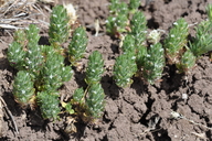
© 2012 Dean Wm. Taylor, Ph.D. |
©2012 Dean Wm. Taylor, Ph.D. |
Taxon Summary:
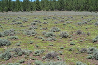
Pogogyne floribunda, commonly known as profuse-flowered pogogyne, is a annual herb in the Lamiaceae that is found in California and elsewhere. It occurs within Meadows and seeps, and Vernal pools, growing at elevations from 945 to 1745 meters. Pogogyne floribunda is ranked 4.2, Plants of Limited Distribution, A Watch List; Moderately threatened in California.|
Scientific Name: Pogogyne floribunda Jokerst |
||
|
Common Name: profuse-flowered pogogyne |
||
| Family: | Lamiaceae | |
| Element Code: | PDLAM1K070 | |
| USDA Plants Symbol: | POFL17 | |
|
Synonyms/Other Names: |
||
| Name Status: |
JEF, FNA, POWO, IPNI, Tropicos |
|
| CA Rare Plant Rank: | 4.2 |
| Fed List: | None |
| State List: | None |
| Global Rank: | G4 |
|
State Rank: |
S3? |
| Other Status: | |
|
CRPR Changes: changed from 1B.2 to 4.2 on 2009-10-26 |
|
| Add Date: | 1994-01-01 |
| Date Edited: | 2025-10-29 |
| Lifeform: annual herb | ||||||||||||||
Blooming Period: May-Sep(Oct)
|
||||||||||||||
|
Elevation:
945 - 1745 meters 3100 - 5725 feet |
||||||||||||||
General Habitats:
|
||||||||||||||
| Microhabitat Details: Heavy clay soils. | ||||||||||||||
Microhabitat:
|
||||||||||||||
| Threat List Total: | 10 | |
| Total EOs | % of EOs | |
| EOs with Threat Listed: | 63 | 60 % |
| THREAT LIST: | ||
|---|---|---|
| Grazing | 54 | 51% |
| Logging | 6 | 5% |
| Other | 6 | 5% |
| Foot traffic/trampling | 5 | 4% |
| ORV activity | 5 | 4% |
| Road/trail construction/maint. | 4 | 3% |
| Improper burning regime | 3 | 2% |
| Development | 2 | 1% |
| Non-native plant impacts | 2 | 1% |
| Recreational use (non-ORV) | 1 | 0% |
| Total Occurrences: | 105 | ||||
| Element Occurrence Ranks: | |||||
|---|---|---|---|---|---|
| A | B | C | D | X | U |
| 13 | 29 | 14 | 1 | 0 | 48 |
| Occurrence Status: | |||||
|---|---|---|---|---|---|
| Historical >20 Years | 85 | ||||
| Recent <=20 Years | 20 | ||||
| Presence: | |||||
|---|---|---|---|---|---|
| Presumed Extant | 105 | ||||
| Possibly Extirpated | 0 | ||||
| Presumed Extirpated | 0 | ||||
| California Endemic: | |||||||||||||
| California Island: | |||||||||||||
|
States: Name (Code) California (CA), Idaho (ID), Oregon (OR) |
|||||||||||||
|
California Counties and Islands: Name (Code) Lassen (LAS), Modoc (MOD), Shasta (SHA), Siskiyou (SIS) |
|||||||||||||
|
Quads: Name (Quad Code) Ambrose (4112058), Bieber (4112112), Big Sage Reservoir (4112056), Boles Meadows East (4112067), Boles Meadows West (4112068), Burney (4012186), Cassel (4012185), Corders Reservoir (4012172), Dana (4112115), Day (4112123), Dead Horse Reservoir (4112065), Donica Mtn. (4112132), Fall River Mills (4112114), Hager Basin (4112077), Jacks Butte (4112057), Jellico (4012173), Knobcone Butte (4112151), Lane Reservoir (4112017), Lauer Reservoir (4112064), Letterbox Hill (4112018), Lone Pine Butte (4112161), Lookout (4112122), Mahogany Ridge (4112055), McGinty Reservoir (4112075), Murken Bench (4012174), Old Station (4012164), Pine Creek Valley (4012151), Pinnacle Lake (4112171), Poison Lake (4012162), Pothole Valley (4112078), Rimrock Lake (4112162), Sagebrush Butte (4112181), Silva Flat Reservoir (4012088), South Mtn. (4112076), Spaulding Butte (4112152), Swains Hole (4012163), Timbered Crater (4112124), Washington Mtn. (4112048), Whittemore Ridge (4112066) |
|||||||||||||
Notes:
|
|||||||||||||
 Presumed Extant
Click on quad for name. Hold Shift Key to use mouse scroll wheel