Taxon Details
Lessingia tenuis
spring lessingia
View Report Copy Link Calflora eFlora CCH CalPhotos iNaturalist
Taxon Summary:
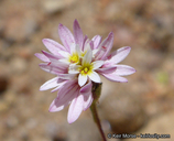
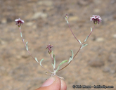
Lessingia tenuis, commonly known as spring lessingia, is a annual herb in the Asteraceae that is found only in California. It occurs within Chaparral, Cismontane woodland, and Lower montane coniferous forest, growing at elevations from 300 to 2150 meters. Lessingia tenuis is ranked 4.3, Plants of Limited Distribution, A Watch List; Not very threatened in California.|
Scientific Name: Lessingia tenuis (Gray) Cov. |
||
|
Common Name: spring lessingia |
||
| Family: | Asteraceae | |
| Element Code: | PDAST5S0B0 | |
| USDA Plants Symbol: | LETE8 | |
|
Synonyms/Other Names: |
||
| Name Status: |
JEF, FNA, POWO, IPNI, Tropicos |
|
| CA Rare Plant Rank: | 4.3 |
| Fed List: | None |
| State List: | None |
| Global Rank: | G4 |
|
State Rank: |
S4 |
| Other Status: | SB_CalBG/RSABG |
|
CRPR Changes: |
|
| Add Date: | 1974-01-01 |
| Date Edited: | 2025-10-29 |
| Lifeform: annual herb | ||||||||||||||
Blooming Period: May-Jul
|
||||||||||||||
|
Elevation:
300 - 2150 meters 985 - 7055 feet |
||||||||||||||
General Habitats:
|
||||||||||||||
| Microhabitat Details: | ||||||||||||||
Microhabitat:
|
||||||||||||||
| Threat List Total: | 0 | |
| Total EOs | % of EOs | |
| EOs with Threat Listed: | 0 | 0 % |
| THREAT LIST: | ||
|---|---|---|
| Total Occurrences: | 0 | ||||
| Element Occurrence Ranks: | |||||
|---|---|---|---|---|---|
| A | B | C | D | X | U |
| 0 | 0 | 0 | 0 | 0 | 0 |
| Occurrence Status: | |||||
|---|---|---|---|---|---|
| Historical >20 Years | 0 | ||||
| Recent <=20 Years | 0 | ||||
| Presence: | |||||
|---|---|---|---|---|---|
| Presumed Extant | 0 | ||||
| Possibly Extirpated | 0 | ||||
| Presumed Extirpated | 0 | ||||
| California Endemic: | |||||||||||||
| California Island: | |||||||||||||
|
States: Name (Code) California (CA) |
|||||||||||||
|
California Counties and Islands: Name (Code) Alameda (ALA), Kern (KRN), Los Angeles (LAX), Monterey (MNT), San Benito (SBT), San Luis Obispo (SLO), San Mateo (SMT), Santa Barbara (SBA), Santa Clara (SCL), Stanislaus (STA), Ventura (VEN) |
|||||||||||||
|
Quads: Name (Quad Code) Alder Peak (3512183), Apache Canyon (3411973), Bear Canyon (3612113), Bickmore Canyon (3612152), Black Mtn. (3411867), Branch Mtn. (3512021), Burnett Peak (3512172), Burro Mountain (3512173), California Valley (3512031), Camatta Ranch (3512043), Cedar Mtn. (3712155), Chimineas Ranch (3511928), Cholame (3512063), Cone Peak (3612114), Cosio Knob (3612112), Crevison Peak (3712122), Cuddy Valley (3411971), Cupertino (3712231), Estrella (3512065), Eylar Mtn. (3712145), Frazier Mtn. (3411878), Guadalupe (3412085), Idria (3612046), Isabel Valley (3712135), Jolon (3512182), Junipero Serra Peak (3612124), La Panza (3512032), La Panza NE (3512041), La Panza Ranch (3512042), Lick Observatory (3712136), Liebre Mtn. (3411866), Lime Mountain (3512068), Lockwood Valley (3411961), Lompoc (3412064), Los Gatos (3712128), Marina (3612167), Miranda Pine Mtn. (3512011), Monterey (3612158), Mt. Boardman (3712144), Mt. Stakes (3712134), North Chalone Peak (3612142), Palo Alto (3712242), Paraiso Springs (3612133), Piru (3411847), Pozo Summit (3512033), Salinas (3612166), San Guillermo (3411962), Santa Margarita (3512045), Santa Maria (3412084), Sawmill Mountain (3411972), Seaside (3612157), Stockdale Mountain (3512085), Sycamore Flat (3612134), Tierra Redonda Mountain (3512078), Topatopa Mountains (3411951), Wilson Corner (3512044) |
|||||||||||||
Notes:
|
|||||||||||||
 Presumed Extant
Click on quad for name. Hold Shift Key to use mouse scroll wheel


