Taxon Details
Fritillaria purdyi
Purdy's fritillary
View Report Copy Link Calflora eFlora CCH CalPhotos iNaturalist

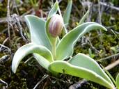
Aaron Schusteff, 2004 |
Jason Matthias Mills, 2020 |
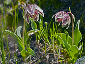
Aaron Schusteff 2004 |
Taxon Summary:
Fritillaria purdyi, commonly known as Purdy's fritillary, is a perennial bulbiferous herb in the Liliaceae that is found in California and elsewhere. It occurs within Chaparral, Cismontane woodland, and Lower montane coniferous forest, growing at elevations from 175 to 2255 meters. Fritillaria purdyi is ranked 4.3, Plants of Limited Distribution, A Watch List; Not very threatened in California.|
Scientific Name: Fritillaria purdyi Eastw. |
||
|
Common Name: Purdy's fritillary |
||
| Family: | Liliaceae | |
| Element Code: | PMLIL0V0H0 | |
| USDA Plants Symbol: | FRPU3 | |
|
Synonyms/Other Names: |
||
| Name Status: |
JEF, FNA, POWO, IPNI, Tropicos |
|
| CA Rare Plant Rank: | 4.3 |
| Fed List: | None |
| State List: | None |
| Global Rank: | G4 |
|
State Rank: |
S4 |
| Other Status: | SB_UCSC |
|
CRPR Changes: |
|
| Add Date: | 1974-01-01 |
| Date Edited: | 2025-10-29 |
| Lifeform: perennial bulbiferous herb | ||||||||||||||
Blooming Period: Mar-Jun
|
||||||||||||||
|
Elevation:
175 - 2255 meters 575 - 7400 feet |
||||||||||||||
General Habitats:
|
||||||||||||||
| Microhabitat Details: | ||||||||||||||
Microhabitat:
|
||||||||||||||
| Threat List Total: | 0 | |
| Total EOs | % of EOs | |
| EOs with Threat Listed: | 0 | 0 % |
| THREAT LIST: | ||
|---|---|---|
| Total Occurrences: | 0 | ||||
| Element Occurrence Ranks: | |||||
|---|---|---|---|---|---|
| A | B | C | D | X | U |
| 0 | 0 | 0 | 0 | 0 | 0 |
| Occurrence Status: | |||||
|---|---|---|---|---|---|
| Historical >20 Years | 0 | ||||
| Recent <=20 Years | 0 | ||||
| Presence: | |||||
|---|---|---|---|---|---|
| Presumed Extant | 0 | ||||
| Possibly Extirpated | 0 | ||||
| Presumed Extirpated | 0 | ||||
| California Endemic: | |||||||||||||
| California Island: | |||||||||||||
|
States: Name (Code) California (CA), Oregon (OR) |
|||||||||||||
|
California Counties and Islands: Name (Code) Colusa (COL), Glenn (GLE), Humboldt (HUM), Lake (LAK), Mendocino (MEN), Napa (NAP), Shasta (SHA), Sonoma (SON), Tehama (TEH), Trinity (TRI), Yolo (YOL) |
|||||||||||||
|
Quads: Name (Quad Code) Aetna Springs (3812264), Bell Springs (3912385), Benmore Canyon (3912215), Black Lassic (4012335), Board Camp Mtn. (4012366), Bridgeville (4012347), Buck Rock (3912288), Calistoga (3812255), Carrville (4112216), Chiles Valley (3812253), Covelo East (3912372), Covelo West (3912373), Covington Mill (4012287), Detert Reservoir (3812265), Dubakella Mtn. (4012342), Grouse Mtn. (4012376), Highland Springs (3812288), Hough Springs (3912225), Hull Mountain (3912258), Iaqua Buttes (4012368), Jamison Ridge (3912362), Jericho Valley (3812274), Knoxville (3812273), Korbel (4012378), Lakeport (3912218), Lewiston (4012267), Mendocino Pass (3912278), Mount St. Helena (3812266), Mumbo Basin (4112225), Newhouse Ridge (3912371), North Yolla Bolly (4012228), Plaskett Meadows (3912267), Plaskett Ridge (3912268), Potter Valley (3912331), Redwood Valley (3912332), Rush Creek Lakes (4012278), Salt Canyon (3912213), Sanhedrin Mtn. (3912351), St. John Mtn. (3912246), Tangle Blue Lake (4112226), The Geysers (3812277), Trinity Center (4012286), Trinity Dam (4012277), Ukiah (3912322), Upper Lake (3912228), Van Arsdale Reservoir (3912341), Walter Springs (3812263), Weaverville (4012268), Whisky Bill Peak (4112215), Whispering Pines (3812276), Wilbur Springs (3912214), Willow Creek (4012386) |
|||||||||||||
Notes:
|
|||||||||||||
 Presumed Extant
Click on quad for name. Hold Shift Key to use mouse scroll wheel