Taxon Details
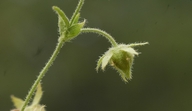
Horkelia parryi
Parry's horkelia
View Report Copy Link Calflora eFlora CCH CalPhotos iNaturalist

© 2009 Barry Breckling |
© 2008 Chris Winchell |

© 2008 Sierra Pacific Industries |
Taxon Summary:
Horkelia parryi, commonly known as Parry's horkelia, is a perennial herb in the Rosaceae that is found only in California. It occurs within Chaparral, and Cismontane woodland, growing at elevations from 80 to 1070 meters. Horkelia parryi is ranked 1B.2, Plants Rare, Threatened or Endangered in California and Elsewhere; Moderately threatened in California.|
Scientific Name: Horkelia parryi Greene |
||
|
Common Name: Parry's horkelia |
||
| Family: | Rosaceae | |
| Element Code: | PDROS0W0C0 | |
| USDA Plants Symbol: | HOPA2 | |
|
Synonyms/Other Names: |
||
| Name Status: |
JEF, FNA, POWO, IPNI, Tropicos |
|
| CA Rare Plant Rank: | 1B.2 |
| Fed List: | None |
| State List: | None |
| Global Rank: | G2 |
|
State Rank: |
S2 |
| Other Status: | BLM_S; USFS_S |
|
CRPR Changes: |
|
| Add Date: | 1974-01-01 |
| Date Edited: | 2025-10-29 |
| Lifeform: perennial herb | ||||||||||||||
Blooming Period: Apr-Sep
|
||||||||||||||
|
Elevation:
80 - 1070 meters 260 - 3510 feet |
||||||||||||||
General Habitats:
|
||||||||||||||
| Microhabitat Details: Ione formation and other soils | ||||||||||||||
|
Microhabitat:
|
||||||||||||||
| Threat List Total: | 13 | |
| Total EOs | % of EOs | |
| EOs with Threat Listed: | 25 | 57 % |
| THREAT LIST: | ||
|---|---|---|
| Road/trail construction/maint. | 17 | 38% |
| ORV activity | 11 | 25% |
| Wood cutting or brush clearing | 8 | 18% |
| Recreational use (non-ORV) | 4 | 9% |
| Erosion/runoff | 3 | 6% |
| Improper burning regime | 3 | 6% |
| Logging | 3 | 6% |
| Mining | 2 | 4% |
| Biocides | 2 | 4% |
| Vandalism/dumping/litter | 2 | 4% |
| Non-native plant impacts | 1 | 2% |
| Grazing | 1 | 2% |
| Other | 1 | 2% |
| Total Occurrences: | 44 | ||||
| Element Occurrence Ranks: | |||||
|---|---|---|---|---|---|
| A | B | C | D | X | U |
| 0 | 16 | 3 | 1 | 0 | 24 |
| Occurrence Status: | |||||
|---|---|---|---|---|---|
| Historical >20 Years | 26 | ||||
| Recent <=20 Years | 18 | ||||
| Presence: | |||||
|---|---|---|---|---|---|
| Presumed Extant | 44 | ||||
| Possibly Extirpated | 0 | ||||
| Presumed Extirpated | 0 | ||||
| California Endemic: | |||||||||||||
| California Island: | |||||||||||||
|
States: Name (Code) California (CA) |
|||||||||||||
|
California Counties and Islands: Name (Code) Amador (AMA), Calaveras (CAL), El Dorado (ELD), Mariposa (MPA), Tuolumne (TUO) |
|||||||||||||
|
Quads: Name (Quad Code) Buckhorn Peak (3712061), Calaveritas (3812025), Camino (3812066), Carbondale (3812141), Columbia Se (3812013), Feliciana Mtn. (3711958), Garden Valley (3812077), Georgetown (3812087), Ione (3812038), Irish Hill (3812048), Kinsley (3711968), Murphys (3812024), Omo Ranch (3812055), Placerville (3812067), Rail Road Flat (3812035), Slate Mtn. (3812076), Stanislaus (3812023), Tunnel Hill (3812086), Wallace (3812028) |
|||||||||||||
Notes:
|
|||||||||||||
 Presumed Extant
Click on quad for name. Hold Shift Key to use mouse scroll wheel