Taxon Details
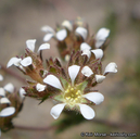
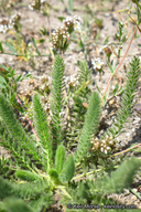
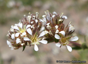
Ivesia unguiculata
Yosemite ivesia
View Report Copy Link Calflora eFlora CCH CalPhotos iNaturalist
© 2020 Keir Morse |
© 2020 Keir Morse |
© 2020 Keir Morse |
Taxon Summary:
Ivesia unguiculata, commonly known as Yosemite ivesia, is a perennial herb in the Rosaceae that is found only in California. It occurs within Meadows and seeps, Subalpine coniferous forest, and Upper montane coniferous forest, growing at elevations from 1500 to 2925 meters. Ivesia unguiculata is ranked 4.2, Plants of Limited Distribution, A Watch List; Moderately threatened in California.|
Scientific Name: Ivesia unguiculata Gray |
||
|
Common Name: Yosemite ivesia |
||
| Family: | Rosaceae | |
| Element Code: | PDROS0X0N0 | |
| USDA Plants Symbol: | IVUN | |
|
Synonyms/Other Names: |
||
| Name Status: |
JEF, FNA, POWO, IPNI, Tropicos |
|
| CA Rare Plant Rank: | 4.2 |
| Fed List: | None |
| State List: | None |
| Global Rank: | G3 |
|
State Rank: |
S3 |
| Other Status: | |
|
CRPR Changes: |
|
| Add Date: | 1974-01-01 |
| Date Edited: | 2025-10-29 |
| Lifeform: perennial herb | ||||||||||||||
Blooming Period: Jun-Sep
|
||||||||||||||
|
Elevation:
1500 - 2925 meters 4920 - 9595 feet |
||||||||||||||
General Habitats:
|
||||||||||||||
| Microhabitat Details: | ||||||||||||||
|
Microhabitat:
|
||||||||||||||
| Threat List Total: | 7 | |
| Total EOs | % of EOs | |
| EOs with Threat Listed: | 13 | 50 % |
| THREAT LIST: | ||
|---|---|---|
| Grazing | 11 | 42% |
| Road/trail construction/maint. | 3 | 11% |
| Other | 2 | 7% |
| Recreational use (non-ORV) | 1 | 3% |
| Logging | 1 | 3% |
| ORV activity | 1 | 3% |
| Development | 1 | 3% |
| Total Occurrences: | 26 | ||||
| Element Occurrence Ranks: | |||||
|---|---|---|---|---|---|
| A | B | C | D | X | U |
| 6 | 2 | 3 | 1 | 2 | 12 |
| Occurrence Status: | |||||
|---|---|---|---|---|---|
| Historical >20 Years | 26 | ||||
| Recent <=20 Years | 0 | ||||
| Presence: | |||||
|---|---|---|---|---|---|
| Presumed Extant | 24 | ||||
| Possibly Extirpated | 1 | ||||
| Presumed Extirpated | 1 | ||||
| California Endemic: | |||||||||||||
| California Island: | |||||||||||||
|
States: Name (Code) California (CA) |
|||||||||||||
|
California Counties and Islands: Name (Code) Fresno (FRE), Madera (MAD), Mariposa (MPA), Mono (MNO), Tuolumne (TUO) |
|||||||||||||
|
Quads: Name (Quad Code) Balloon Dome (3711942), Cattle Mtn. (3711952), Courtright Reservoir (3711818), Dinkey Creek (3711912), Dogtooth Peak (3711921), El Capitan (3711966), Graveyard Peak (3711848), Half Dome (3711965), Hume (3611878), Huntington Lake (3711922), Kaiser Peak (3711932), Mariposa Grove (3711955), Mt. Givens (3711931), Musick Mtn. (3711923), Nelson Mtn. (3711911), Patterson Mtn. (3611981), Pickel Meadow (3811935), Rough Spur (3611888), Sharktooth Peak (3711941), Shaver Lake (3711913), Squaw Dome (3711943), Tenaya Lake (3711974), Timber Knob (3711953), Tower Peak (3811925), Ward Mountain (3711828) |
|||||||||||||
Notes:
|
|||||||||||||
 Presumed Extant
Click on quad for name. Hold Shift Key to use mouse scroll wheel