Taxon Details
Juncus hemiendytus var. abjectus
Center Basin rush
View Report Copy Link Calflora eFlora CCH CalPhotos iNaturalist
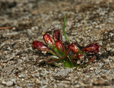
©2008 Steve Matson |
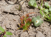
©2010 Neal Kramer |
Taxon Summary:
Juncus hemiendytus var. abjectus, commonly known as Center Basin rush, is a annual herb in the Juncaceae that is found in California and elsewhere. It occurs within Meadows and seeps, and Subalpine coniferous forest, growing at elevations from 1400 to 3400 meters. Juncus hemiendytus var. abjectus is ranked 4.3, Plants of Limited Distribution, A Watch List; Not very threatened in California.|
Scientific Name: Juncus hemiendytus F.J. Herm. var. abjectus (F.J. Herm.) B. Ertter |
||
|
Common Name: Center Basin rush |
||
| Family: | Juncaceae | |
| Element Code: | PMJUN011F1 | |
| USDA Plants Symbol: | JUHEA | |
|
Synonyms/Other Names: |
||
| Name Status: |
JEF, FNA, POWO, IPNI, Tropicos |
|
| CA Rare Plant Rank: | 4.3 |
| Fed List: | None |
| State List: | None |
| Global Rank: | G5T5 |
|
State Rank: |
S4 |
| Other Status: | |
|
CRPR Changes: |
|
| Add Date: | 1974-01-01 |
| Date Edited: | 2025-10-29 |
| Lifeform: annual herb | ||||||||||||||
Blooming Period: May-Jun(Jul)
|
||||||||||||||
|
Elevation:
1400 - 3400 meters 4595 - 11155 feet |
||||||||||||||
General Habitats:
|
||||||||||||||
| Microhabitat Details: | ||||||||||||||
Microhabitat:
|
||||||||||||||
| Threat List Total: | 0 | |
| Total EOs | % of EOs | |
| EOs with Threat Listed: | 0 | 0 % |
| THREAT LIST: | ||
|---|---|---|
| Total Occurrences: | 0 | ||||
| Element Occurrence Ranks: | |||||
|---|---|---|---|---|---|
| A | B | C | D | X | U |
| 0 | 0 | 0 | 0 | 0 | 0 |
| Occurrence Status: | |||||
|---|---|---|---|---|---|
| Historical >20 Years | 0 | ||||
| Recent <=20 Years | 0 | ||||
| Presence: | |||||
|---|---|---|---|---|---|
| Presumed Extant | 0 | ||||
| Possibly Extirpated | 0 | ||||
| Presumed Extirpated | 0 | ||||
| California Endemic: | |||||||||||||
| California Island: | |||||||||||||
|
States: Name (Code) California (CA), Idaho (ID), Nevada (NV), Oregon (OR) |
|||||||||||||
|
California Counties and Islands: Name (Code) Alpine (ALP), Fresno (FRE), Lassen (LAS), Modoc (MOD), Mono (MNO), Nevada (NEV), Placer (PLA), Plumas (PLU), Shasta (SHA), Sierra (SIE), Siskiyou (SIS), Tulare (TUL), Tuolumne (TUO) |
|||||||||||||
|
Quads: Name (Quad Code) Antelope Mtn. (4012058), Beaver Mtn. (4112086), Boca (3912041), Bullard Lake (4012078), Champs Flat (4012068), Crank Mountain (4112142), Crocker Mtn. (3912084), Dog Valley (3912051), Donica Mtn. (4112132), Dunderberg Peak (3811913), Falls Ridge (3711984), Freel Peak (3811978), Harvey Mtn. (4012161), Hobart Mills (3912042), Johnson Peak (3611843), Knobcone Butte (4112151), Lake Annie (4112081), Letterbox Hill (4112018), Martis Peak (3912031), Mount Dana (3711982), Mount Whitney (3611853), Mt. Abbot (3711847), Mt. Williamson (3611863), Norden (3912033), Old Station (4012164), Pegleg Mtn. (4012048), Pikes Point (4012057), Pine Creek Valley (4012151), Portola (3912074), Sheepshead (4012077), Spalding Tract (4012067), Squaw Valley Peak (4012014), Swain Mountain (4012141), Tioga Pass (3711983), Topaz Lake (3811965), Vogelsang Peak (3711973) |
|||||||||||||
Notes:
|
|||||||||||||
 Presumed Extant
Click on quad for name. Hold Shift Key to use mouse scroll wheel