Taxon Details
Iris longipetala
coast iris
View Report Copy Link Calflora eFlora CCH CalPhotos iNaturalist
Taxon Summary:
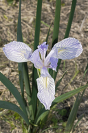
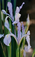
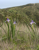
Iris longipetala, commonly known as coast iris, is a perennial rhizomatous herb in the Iridaceae that is found only in California. It occurs within Coastal prairie, Lower montane coniferous forest, and Meadows and seeps, growing at elevations from 0 to 600 meters. Iris longipetala is ranked 4.2, Plants of Limited Distribution, A Watch List; Moderately threatened in California.|
Scientific Name: Iris longipetala Herbert |
||
|
Common Name: coast iris |
||
| Family: | Iridaceae | |
| Element Code: | PMIRI092E0 | |
| USDA Plants Symbol: | ||
|
Synonyms/Other Names: |
||
| Name Status: |
JEF, FNA, POWO, IPNI, Tropicos |
|
| CA Rare Plant Rank: | 4.2 |
| Fed List: | None |
| State List: | None |
| Global Rank: | G3 |
|
State Rank: |
S3 |
| Other Status: | SB_UCSC |
|
CRPR Changes: added to 4.2 on 2006-10-12 |
|
| Add Date: | 2006-10-12 |
| Date Edited: | 2025-10-29 |
| Lifeform: perennial rhizomatous herb | ||||||||||||||
Blooming Period: Mar-May(Jun)
|
||||||||||||||
|
Elevation:
0 - 600 meters 0 - 1970 feet |
||||||||||||||
General Habitats:
|
||||||||||||||
| Microhabitat Details: | ||||||||||||||
Microhabitat:
|
||||||||||||||
| Threat List Total: | 0 | |
| Total EOs | % of EOs | |
| EOs with Threat Listed: | 0 | 0 % |
| THREAT LIST: | ||
|---|---|---|
| Total Occurrences: | 0 | ||||
| Element Occurrence Ranks: | |||||
|---|---|---|---|---|---|
| A | B | C | D | X | U |
| 0 | 0 | 0 | 0 | 0 | 0 |
| Occurrence Status: | |||||
|---|---|---|---|---|---|
| Historical >20 Years | 0 | ||||
| Recent <=20 Years | 0 | ||||
| Presence: | |||||
|---|---|---|---|---|---|
| Presumed Extant | 0 | ||||
| Possibly Extirpated | 0 | ||||
| Presumed Extirpated | 0 | ||||
| California Endemic: | |||||||||||||
| California Island: | |||||||||||||
|
States: Name (Code) California (CA) |
|||||||||||||
|
California Counties and Islands: Name (Code) Alameda (ALA), Contra Costa (CCA), El Dorado (ELD), Glenn (GLE), Humboldt (HUM), Marin (MRN), Mendocino (MEN), Merced (MER), Monterey (MNT), San Francisco (SFO), San Mateo (SMT), Santa Clara (SCL), Santa Cruz (SCR), Solano (SOL), Sonoma (SON), Ventura (VEN) |
|||||||||||||
|
Quads: Name (Quad Code) Ano Nuevo (3712213), Big Basin (3712222), Briones Valley (3712282), Camp Meeker (3812248), Cape San Martin (3512184), Clarksville (3812161), Cloverdale (3812371), Cooskie Creek (4012423), Cordelia (3812222), Cotati (3812236), Cupertino (3712231), Drakes Bay (3812218), Duncans Mills (3812341), Fairfield South (3812221), Felton (3712211), Franklin Point (3712223), Frazier Mtn. (3411878), Glen Ellen (3812235), Gualala (3812375), Half Moon Bay (3712244), Hopland (3812381)?, Inglenook (3912357), Kenwood (3812245), Lick Observatory (3712136), Mariposa Peak (3612182), Montara Mountain (3712254), Monterey (3612158), Novato (3812215), Palo Alto (3712242), Petaluma River (3812225), Pigeon Point (3712224), Plantation (3812353), Plaskett Meadows (3912267), Plaskett Ridge (3912268), Prunedale (3612176), Richmond (3712283), San Francisco North (3712274), San Francisco South (3712264), San Geronimo (3812216), San Jose East (3712137), San Juan Bautista (3612175), San Mateo (3712253), San Quentin (3712284), San Rafael (3712285), Sebastopol (3812247), Tomales (3812228), Two Rock (3812237), Watsonville East (3612186), Woodside (3712243) |
|||||||||||||
Notes:
|
|||||||||||||
 Presumed Extant
Click on quad for name. Hold Shift Key to use mouse scroll wheel


