Taxon Details
Erigeron petrophilus var. viscidulus
Klamath rock daisy
View Report Copy Link Calflora eFlora CCH CalPhotos iNaturalist
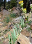
©2014 Neal Kramer |
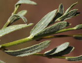
©2014 Steve Matson |

©2014 Steve Matson |
Taxon Summary:
Erigeron petrophilus var. viscidulus, commonly known as Klamath rock daisy, is a perennial rhizomatous herb in the Asteraceae that is found in California and elsewhere. It occurs within Chaparral, Lower montane coniferous forest, Meadows and seeps, and Upper montane coniferous forest, growing at elevations from 1500 to 2700 meters. Erigeron petrophilus var. viscidulus is ranked 4.3, Plants of Limited Distribution, A Watch List; Not very threatened in California.|
Scientific Name: Erigeron petrophilus Greene var. viscidulus (Gray) G. Nesom |
||
|
Common Name: Klamath rock daisy |
||
| Family: | Asteraceae | |
| Element Code: | PDAST3M352 | |
| USDA Plants Symbol: | ERPEV | |
|
Synonyms/Other Names: |
||
| Name Status: |
JEF, FNA, POWO, IPNI, Tropicos |
|
| CA Rare Plant Rank: | 4.3 |
| Fed List: | None |
| State List: | None |
| Global Rank: | G4T4 |
|
State Rank: |
S4 |
| Other Status: | |
|
CRPR Changes: |
|
| Add Date: | 1994-01-01 |
| Date Edited: | 2025-10-29 |
| Lifeform: perennial rhizomatous herb | ||||||||||||||
Blooming Period: Jul-Sep
|
||||||||||||||
|
Elevation:
1500 - 2700 meters 4920 - 8860 feet |
||||||||||||||
General Habitats:
|
||||||||||||||
| Microhabitat Details: | ||||||||||||||
Microhabitat:
|
||||||||||||||
| Threat List Total: | 0 | |
| Total EOs | % of EOs | |
| EOs with Threat Listed: | 0 | 0 % |
| THREAT LIST: | ||
|---|---|---|
| Total Occurrences: | 0 | ||||
| Element Occurrence Ranks: | |||||
|---|---|---|---|---|---|
| A | B | C | D | X | U |
| 0 | 0 | 0 | 0 | 0 | 0 |
| Occurrence Status: | |||||
|---|---|---|---|---|---|
| Historical >20 Years | 0 | ||||
| Recent <=20 Years | 0 | ||||
| Presence: | |||||
|---|---|---|---|---|---|
| Presumed Extant | 0 | ||||
| Possibly Extirpated | 0 | ||||
| Presumed Extirpated | 0 | ||||
| California Endemic: | |||||||||||||
| California Island: | |||||||||||||
|
States: Name (Code) California (CA), Oregon (OR) |
|||||||||||||
|
California Counties and Islands: Name (Code) Mendocino (MEN), Shasta (SHA), Siskiyou (SIS), Trinity (TRI) |
|||||||||||||
|
Quads: Name (Quad Code) Boulder Peak (4112351), Caribou Lake (4112218), Carrville (4112216), Cecil Lake (4112312), China Mtn. (4112245), Condrey Mtn. (4112288), Covington Mill (4012287), Dees Peak (4112313), Dunsmuir (4112223), Dutch Creek (4112381), Eaton Peak (4112238), Four Corners Rock (4012312), Kangaroo Mtn. (4112382), Leech Lake Mtn. (3912381), Long Ridge (4012313), Mount Eddy (4112234), Mt. Hilton (4012381), Mumbo Basin (4112225), Rush Creek Lakes (4012278), Scott Bar (4112361), Scott Mountain (4112236), Seven Lakes Basin (4112224), Siligo Peak (4012288), South China Mtn. (4112235), Swim Ridge (4012322), Thompson Peak (4112311), Thurston Peaks (4012382), Ukonom Lake (4112353), Ycatapom Peak (4112217) |
|||||||||||||
Notes:
|
|||||||||||||
 Presumed Extant
Click on quad for name. Hold Shift Key to use mouse scroll wheel