Taxon Details
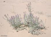
Astragalus lentiginosus var. borreganus
Borrego milk-vetch
View Report Copy Link Calflora eFlora CCH CalPhotos iNaturalist
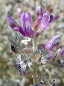
© 2009 Keir Morse |

© 2009 Keir Morse |
© 2009 Keir Morse |
Taxon Summary:
Astragalus lentiginosus var. borreganus, commonly known as Borrego milk-vetch, is a annual herb in the Fabaceae that is found in California and elsewhere. It occurs within Mojavean desert scrub, and Sonoran desert scrub, growing at elevations from 30 to 895 meters. Astragalus lentiginosus var. borreganus is ranked 4.3, Plants of Limited Distribution, A Watch List; Not very threatened in California.|
Scientific Name: Astragalus lentiginosus Hook. var. borreganus Jones |
||
|
Common Name: Borrego milk-vetch |
||
| Family: | Fabaceae | |
| Element Code: | PDFAB0FB95 | |
| USDA Plants Symbol: | ASLEB | |
|
Synonyms/Other Names: |
||
| Name Status: |
JEF, FNA, POWO, IPNI, Tropicos |
|
| CA Rare Plant Rank: | 4.3 |
| Fed List: | None |
| State List: | None |
| Global Rank: | G5T5? |
|
State Rank: |
S4 |
| Other Status: | |
|
CRPR Changes: |
|
| Add Date: | 1974-01-01 |
| Date Edited: | 2026-06-10 |
| Lifeform: annual herb | ||||||||||||||
Blooming Period: Feb-May
|
||||||||||||||
|
Elevation:
30 - 895 meters 100 - 2935 feet |
||||||||||||||
General Habitats:
|
||||||||||||||
| Microhabitat Details: | ||||||||||||||
Microhabitat:
|
||||||||||||||
| Threat List Total: | 0 | |
| Total EOs | % of EOs | |
| EOs with Threat Listed: | 0 | 0 % |
| THREAT LIST: | ||
|---|---|---|
| Total Occurrences: | 0 | ||||
| Element Occurrence Ranks: | |||||
|---|---|---|---|---|---|
| A | B | C | D | X | U |
| 0 | 0 | 0 | 0 | 0 | 0 |
| Occurrence Status: | |||||
|---|---|---|---|---|---|
| Historical >20 Years | 0 | ||||
| Recent <=20 Years | 0 | ||||
| Presence: | |||||
|---|---|---|---|---|---|
| Presumed Extant | 0 | ||||
| Possibly Extirpated | 0 | ||||
| Presumed Extirpated | 0 | ||||
| California Endemic: | |||||||||||||
| California Island: | |||||||||||||
|
States: Name (Code) Arizona (AZ), Baja California (BA), California (CA), Nevada (NV), Sonora, Mexico (SO) |
|||||||||||||
|
California Counties and Islands: Name (Code) Imperial (IMP), Inyo (INY), Riverside (RIV), San Bernardino (SBD), San Diego (SDG) |
|||||||||||||
|
Quads: Name (Quad Code) Grays Well (3211468), Grays Well NE (3211467), Acolita (3311512), Amos (3311513), Baker (3511631), Barstow (3411781), Beaumont (3311688), Borrego Mountain (3311622), Borrego Palm Canyon (3311634), Borrego Sink (3311623), Cabazon (3311687), Cactus (3211478), Cadiz Lake (3411534), Cadiz Valley SE (3411513), Cathedral City (3311674), Cave Mountain (3511613), Clark Lake (3311633), Cowhole Mountain (3511518), Cronese Lakes (3511623), Danby Lake (3411521), Desert (3511553), Dumont Dunes (3511662), East of Granite Pass (3411511), Fonts Point (3311632), Glamis (3211581), Glasgow (3411587), Kelso (3511516), Kelso Dunes (3411586), Kingston Peak (3511568), Myoma (3311673), New Dale (3411516), Nipton (3511543), North of Baker (3511641), Ogilby (3211477), Old Dad Mtn. (3511517), Palo Verde (3311446), Shell Reef (3311621), Soda Lake North (3511621), Soda Lake South (3511611), Trona East (3511773), Trona West (3511774), Tubb Canyon (3311624), White Horse Mtn. (3411658) |
|||||||||||||
Notes:
|
|||||||||||||
 Presumed Extant
Click on quad for name. Hold Shift Key to use mouse scroll wheel