Taxon Details
Downingia pusilla
dwarf downingia
View Report Copy Link Calflora eFlora CCH CalPhotos iNaturalist

© 2013 Aaron Arthur |
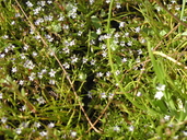
© 2012 Jake Ruygt |

© 2011 Dylan Neubauer |
Taxon Summary:
Downingia pusilla, commonly known as dwarf downingia, is a annual herb in the Campanulaceae that is found in California and elsewhere. It occurs within Valley and foothill grassland (mesic), and Vernal pools, growing at elevations from 1 to 445 meters. Downingia pusilla is ranked 2B.2, Plants Rare, Threatened, or Endangered in California, But More Common Elsewhere; Moderately threatened in California.|
Scientific Name: Downingia pusilla (D. Don) Torr. |
||
|
Common Name: dwarf downingia |
||
| Family: | Campanulaceae | |
| Element Code: | PDCAM060C0 | |
| USDA Plants Symbol: | DOPU3 | |
|
Synonyms/Other Names: |
||
| Name Status: |
JEF, FNA, POWO, IPNI, Tropicos |
|
| CA Rare Plant Rank: | 2B.2 |
| Fed List: | None |
| State List: | None |
| Global Rank: | GU |
|
State Rank: |
S2 |
| Other Status: | |
|
CRPR Changes: |
|
| Add Date: | 1980-01-01 |
| Date Edited: | 2021-05-26 |
| Lifeform: annual herb | ||||||||||||||
Blooming Period: Mar-May
|
||||||||||||||
|
Elevation:
1 - 445 meters 5 - 1460 feet |
||||||||||||||
General Habitats:
|
||||||||||||||
| Microhabitat Details: | ||||||||||||||
|
Microhabitat:
|
||||||||||||||
| Threat List Total: | 19 | |
| Total EOs | % of EOs | |
| EOs with Threat Listed: | 81 | 61 % |
| THREAT LIST: | ||
|---|---|---|
| Grazing | 49 | 37% |
| Development | 39 | 29% |
| Agriculture | 13 | 9% |
| Other | 10 | 7% |
| ORV activity | 7 | 5% |
| Non-native plant impacts | 6 | 4% |
| Road/trail construction/maint. | 6 | 4% |
| Erosion/runoff | 6 | 4% |
| Disking | 5 | 3% |
| Foot traffic/trampling | 3 | 2% |
| Dam/Inundation | 3 | 2% |
| Surface water diversion | 2 | 1% |
| Biocides | 2 | 1% |
| Improper burning regime | 1 | 0% |
| Mining | 1 | 0% |
| Vandalism/dumping/litter | 1 | 0% |
| Over-collecting/poaching | 1 | 0% |
| Pollution | 1 | 0% |
| Recreational use (non-ORV) | 1 | 0% |
| Total Occurrences: | 132 | ||||
| Element Occurrence Ranks: | |||||
|---|---|---|---|---|---|
| A | B | C | D | X | U |
| 13 | 50 | 10 | 6 | 7 | 46 |
| Occurrence Status: | |||||
|---|---|---|---|---|---|
| Historical >20 Years | 107 | ||||
| Recent <=20 Years | 25 | ||||
| Presence: | |||||
|---|---|---|---|---|---|
| Presumed Extant | 125 | ||||
| Possibly Extirpated | 2 | ||||
| Presumed Extirpated | 5 | ||||
| California Endemic: | |||||||||||||
| California Island: | |||||||||||||
|
States: Name (Code) California (CA), South America (SA) |
|||||||||||||
|
California Counties and Islands: Name (Code) Fresno (FRE), Merced (MER), Napa (NAP), Placer (PLA), Sacramento (SAC), San Joaquin (SJQ), Solano (SOL), Sonoma (SON), Stanislaus (STA), Tehama (TEH), Yuba (YUB) |
|||||||||||||
|
Quads: Name (Quad Code) Allendale (3812148), Antioch North (3812117), Black Butte Dam (3912273), Browns Valley (3912124), Camp Far West (3912113), Capell Valley (3812242), Clay (3812132), Cooperstown (3712065), Corning (3912282), Cuttings Wharf (3812223), Denverton (3812128), Dozier (3812137), Elk Grove (3812143), Elmira (3812138), Florin (3812144), Folsom (3812162), Friant (3611986), Galt (3812133), Gerber (4012212), Glen Ellen (3812235), Goose Creek (3812131), Healdsburg (3812257), Henleyville (3912283), Kenwood (3812245), Knights Ferry (3712076), La Grange (3712064), Lincoln (3812183), Merced (3712034), Merced Falls (3712053), Mt. George (3812232), Napa (3812233), Owens Reservoir (3712032), Pleasant Grove (3812174), Red Bluff East (4012222), Richardson Springs NW (3912188), Rio Linda (3812164), Roseville (3812173), Sears Point (3812224), Sebastopol (3812247), Sheridan (3812184), Smartville (3912123), Snelling (3712054), Sonoma (3812234), Vina (3912281), West of Gerber (4012213), Wheatland (3912114), Yosemite Lake (3712044), Yountville (3812243) |
|||||||||||||
Notes:
|
|||||||||||||
 Presumed Extant
Click on quad for name. Hold Shift Key to use mouse scroll wheel