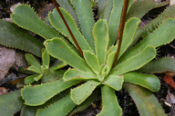
Taxon Details
Lewisia cantelovii
Cantelow's lewisia
View Report Copy Link Calflora eFlora CCH CalPhotos iNaturalist
Taxon Summary:
Lewisia cantelovii, commonly known as Cantelow's lewisia, is a perennial herb in the Montiaceae that is found only in California. It occurs within Broadleafed upland forest, Chaparral, Cismontane woodland, and Lower montane coniferous forest, growing at elevations from 330 to 1370 meters. Lewisia cantelovii is ranked 1B.2, Plants Rare, Threatened or Endangered in California and Elsewhere; Moderately threatened in California.|
Scientific Name: Lewisia cantelovii J.T. Howell |
||
|
Common Name: Cantelow's lewisia |
||
| Family: | Montiaceae | |
| Element Code: | PDPOR04020 | |
| USDA Plants Symbol: | LECA11 | |
|
Synonyms/Other Names: |
||
| Name Status: |
JEF, FNA, POWO, IPNI, Tropicos |
|
| CA Rare Plant Rank: | 1B.2 |
| Fed List: | None |
| State List: | None |
| Global Rank: | G3 |
|
State Rank: |
S3 |
| Other Status: | BLM_S; SB_UCSC; USFS_S |
|
CRPR Changes: |
|
| Add Date: | 1974-01-01 |
| Date Edited: | 2025-10-29 |
| Lifeform: perennial herb | ||||||||||||||
Blooming Period: May-Oct
|
||||||||||||||
|
Elevation:
330 - 1370 meters 1085 - 4495 feet |
||||||||||||||
General Habitats:
|
||||||||||||||
| Microhabitat Details: | ||||||||||||||
Microhabitat:
|
||||||||||||||
|
Notes: Threatened by horticultural collecting and road maintenance. Possibly threatened by non-native plants, mining and logging. Does not include L. serrata. See Leaflets of Western Botany 3(6):139 (1942) for original description, and Fremontia 25(1):15-19 (1997) for genetic study of relationship to L. serrata. |
|
|
Threats: Threatened by horticultural collecting and road maintenance. |
|
|
Taxonomy: Does not include L. serrata |
|
| Threat List Total: | 10 | |
| Total EOs | % of EOs | |
| EOs with Threat Listed: | 34 | 47 % |
| THREAT LIST: | ||
|---|---|---|
| Road/trail construction/maint. | 18 | 24% |
| Mining | 12 | 16% |
| Recreational use (non-ORV) | 9 | 12% |
| Over-collecting/poaching | 7 | 9% |
| Erosion/runoff | 4 | 5% |
| Logging | 4 | 5% |
| Dam/Inundation | 2 | 2% |
| Non-native plant impacts | 2 | 2% |
| Foot traffic/trampling | 1 | 1% |
| Vandalism/dumping/litter | 1 | 1% |
| Total Occurrences: | 73 | ||||
| Element Occurrence Ranks: | |||||
|---|---|---|---|---|---|
| A | B | C | D | X | U |
| 21 | 23 | 4 | 0 | 0 | 25 |
| Occurrence Status: | |||||
|---|---|---|---|---|---|
| Historical >20 Years | 50 | ||||
| Recent <=20 Years | 23 | ||||
| Presence: | |||||
|---|---|---|---|---|---|
| Presumed Extant | 73 | ||||
| Possibly Extirpated | 0 | ||||
| Presumed Extirpated | 0 | ||||
| California Endemic: | |||||||||||||
| California Island: | |||||||||||||
|
States: Name (Code) California (CA) |
|||||||||||||
|
California Counties and Islands: Name (Code) Butte (BUT), Nevada (NEV), Plumas (PLU), Shasta (SHA), Sierra (SIE), Yuba (YUB) |
|||||||||||||
|
Quads: Name (Quad Code) Alleghany (3912047), Belden (4012113), Bohemotash Mtn. (4012274), Brush Creek (3912163), Caribou (4012112), Dogwood Peak (3912171), Downieville (3912057), Goodyears Bar (3912058), Hanland Peak (4012283), Lamoine (4012284), Nevada City (3912131), North Bloomfield (3912038), Onion Valley (3912078), Pike (3912048), Pulga (3912174), Shoeinhorse Mtn. (4112211), Soapstone Hill (3912173), Storrie (3912183), Strawberry Valley (3912151), Tombstone Mtn. (4112213), Washington (3912037), Yellowjacket Mtn. (4112212) |
|||||||||||||
Notes:
|
|||||||||||||
 Presumed Extant
Click on quad for name. Hold Shift Key to use mouse scroll wheel


