Taxon Details
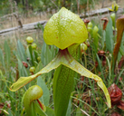
Darlingtonia californica
California pitcherplant
View Report Copy Link Calflora eFlora CCH CalPhotos iNaturalist
© 2021 Scot Loring |

© 2020 Neal Kramer |

©2018 Barry Rice |
Taxon Summary:
Darlingtonia californica, commonly known as California pitcherplant, is a perennial rhizomatous herb (carnivorous) in the Sarraceniaceae that is found in California and elsewhere. It occurs within Bogs and fens, and Meadows and seeps, growing at elevations from 0 to 2585 meters. Darlingtonia californica is ranked 4.2, Plants of Limited Distribution, A Watch List; Moderately threatened in California.|
Scientific Name: Darlingtonia californica Torr. |
||
|
Common Name: California pitcherplant |
||
| Family: | Sarraceniaceae | |
| Element Code: | PDSAR01010 | |
| USDA Plants Symbol: | DACA5 | |
|
Synonyms/Other Names: |
||
| Name Status: |
JEF, FNA, POWO, IPNI, Tropicos |
|
| CA Rare Plant Rank: | 4.2 |
| Fed List: | None |
| State List: | None |
| Global Rank: | G4 |
|
State Rank: |
S4 |
| Other Status: | IUCN_LC; SB_CalBG/RSABG |
|
CRPR Changes: |
|
| Add Date: | 1980-01-01 |
| Date Edited: | 2025-10-29 |
| Lifeform: perennial rhizomatous herb (carnivorous) | ||||||||||||||
Blooming Period: Apr-Aug
|
||||||||||||||
|
Elevation:
0 - 2585 meters 0 - 8480 feet |
||||||||||||||
General Habitats:
|
||||||||||||||
| Microhabitat Details: | ||||||||||||||
Microhabitat:
|
||||||||||||||
| Threat List Total: | 0 | |
| Total EOs | % of EOs | |
| EOs with Threat Listed: | 0 | 0 % |
| THREAT LIST: | ||
|---|---|---|
| Total Occurrences: | 0 | ||||
| Element Occurrence Ranks: | |||||
|---|---|---|---|---|---|
| A | B | C | D | X | U |
| 0 | 0 | 0 | 0 | 0 | 0 |
| Occurrence Status: | |||||
|---|---|---|---|---|---|
| Historical >20 Years | 0 | ||||
| Recent <=20 Years | 0 | ||||
| Presence: | |||||
|---|---|---|---|---|---|
| Presumed Extant | 0 | ||||
| Possibly Extirpated | 0 | ||||
| Presumed Extirpated | 0 | ||||
| California Endemic: | |||||||||||||
| California Island: | |||||||||||||
|
States: Name (Code) California (CA), Oregon (OR) |
|||||||||||||
|
California Counties and Islands: Name (Code) Butte (BUT), Del Norte (DNT), Humboldt (HUM), Mendocino (MEN), Nevada (NEV), Plumas (PLU), Shasta (SHA), Sierra (SIE), Siskiyou (SIS), Trinity (TRI), Yuba (YUB) |
|||||||||||||
|
Quads: Name (Quad Code) American House (3912161), Billys Peak (4112227), Blue Canyon (3912036), Broken Rib Mtn. (4112386), Bucks Lake (3912182), Callahan (4112237), Cant Hook Mtn. (4112368), Caribou (4012112), Caribou Lake (4112218), Carrville (4112216), Chicken Hawk Hill (4112214), Childs Hill (4112461), Chimney Rock (4112356), China Mtn. (4112245), Cisco Grove (3912035), City of Mount Shasta (4112233), Covington Mill (4012287), Crescent Mills (4012018), Devils Punchbowl (4112376), Dunsmuir (4112223), English Mtn. (3912045), Etna (4112248), Fort Jones (4112257), Gasquet (4112378), Gazelle Mtn. (4112246), Goodyears Bar (3912058), Graniteville (3912046), Greenview (4112258), High Divide (4112481), High Plateau Mtn. (4112388), Hiouchi (4112471), Hurdygurdy Butte (4112377), Jonesville (4012114), Klamath Glen (4112358), Mathison Peak (3912336), Meadow Valley (3912181), Mount Eddy (4112234), Mumbo Basin (4112225), North Bloomfield (3912038), Olivehurst (3912115), Orick (4112431), Polar Bear Mtn. (4112385), Prescott Mtn. (4112366), Preston Peak (4112375), Quincy (3912088), Rush Creek Lakes (4012278), Scott Mountain (4112236), Seven Lakes Basin (4112224), Shelly Creek Ridge (4112387), Ship Mountain (4112367), Sierra City (3912056), Siligo Peak (4012288), Smith River (4112482), South China Mtn. (4112235), Strawberry Valley (3912151), Summit Valley (4112357), Tangle Blue Lake (4112226), Thompson Peak (4112311), Trinity Center (4012286), Twain (4012111), Whisky Bill Peak (4112215), Ycatapom Peak (4112217) |
|||||||||||||
Notes:
|
|||||||||||||
 Presumed Extant
Click on quad for name. Hold Shift Key to use mouse scroll wheel