Taxon Details
Eriastrum hooveri
Hoover's eriastrum
View Report Copy Link Calflora eFlora CCH CalPhotos iNaturalist
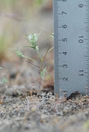
© 2011 Chris Winchell |
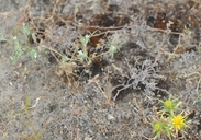
© 2011 Chris Winchell |

© 2011 Chris Winchell |
Taxon Summary:
Eriastrum hooveri, commonly known as Hoover's eriastrum, is a annual herb in the Polemoniaceae that is found only in California. It occurs within Chenopod scrub, Pinyon and juniper woodland, and Valley and foothill grassland, growing at elevations from 50 to 915 meters. Eriastrum hooveri is ranked 4.2, Plants of Limited Distribution, A Watch List; Moderately threatened in California.|
Scientific Name: Eriastrum hooveri (Jeps.) Mason |
||
|
Common Name: Hoover's eriastrum |
||
| Family: | Polemoniaceae | |
| Element Code: | PDPLM03070 | |
| USDA Plants Symbol: | ERHO2 | |
|
Synonyms/Other Names: |
||
| Name Status: |
JEF, FNA, POWO, IPNI, Tropicos |
|
| CA Rare Plant Rank: | 4.2 |
| Fed List: | FD (2003-10-07) |
| State List: | None |
| Global Rank: | G3 |
|
State Rank: |
S3 |
| Other Status: | SB_CalBG/RSABG |
|
CRPR Changes: |
|
| Add Date: | 1974-01-01 |
| Date Edited: | 2025-10-29 |
| Lifeform: annual herb | ||||||||||||||
Blooming Period: Mar-Jul
|
||||||||||||||
|
Elevation:
50 - 915 meters 165 - 3000 feet |
||||||||||||||
General Habitats:
|
||||||||||||||
| Microhabitat Details: | ||||||||||||||
Microhabitat:
|
||||||||||||||
|
Notes: Federally listed as Threatened on 1990-08-20, Delisted due to Recovery on 2003-10-07. Threatened by agriculture, grazing, urbanization, energy development, and vehicles. See Madroño 45(4):290-300 (1998) for ecological information and 46(4):215-216 (1999) for distributional information. |
|
|
Threats: |
|
|
Taxonomy: |
|
| Threat List Total: | 9 | |
| Total EOs | % of EOs | |
| EOs with Threat Listed: | 36 | 77 % |
| THREAT LIST: | ||
|---|---|---|
| Grazing | 19 | 40% |
| Agriculture | 17 | 36% |
| Mining | 9 | 19% |
| Development | 8 | 17% |
| ORV activity | 5 | 10% |
| Vandalism/dumping/litter | 4 | 8% |
| Altered flood/tidal/hydrologic regime | 3 | 6% |
| Foot traffic/trampling | 2 | 4% |
| Pollution | 1 | 2% |
| Total Occurrences: | 47 | ||||
| Element Occurrence Ranks: | |||||
|---|---|---|---|---|---|
| A | B | C | D | X | U |
| 4 | 14 | 8 | 0 | 11 | 10 |
| Occurrence Status: | |||||
|---|---|---|---|---|---|
| Historical >20 Years | 47 | ||||
| Recent <=20 Years | 0 | ||||
| Presence: | |||||
|---|---|---|---|---|---|
| Presumed Extant | 36 | ||||
| Possibly Extirpated | 2 | ||||
| Presumed Extirpated | 9 | ||||
| California Endemic: | |||||||||||||
| California Island: | |||||||||||||
|
States: Name (Code) California (CA) |
|||||||||||||
|
California Counties and Islands: Name (Code) Fresno (FRE), Kern (KRN), Kings (KNG), San Luis Obispo (SLO), Santa Barbara (SBA) |
|||||||||||||
|
Quads: Name (Quad Code) Antelope Plain (3511967), Arvin (3511827), Auberry (3711914), Avenal (3612012), Avenal Gap (3511978), Ballinger Canyon (3411984), Bear Mountain (3511826), Belridge (3511946), Buttonwillow (3511944), Coalinga (3612023), Curry Mountain (3612014), Cuyama (3411985), Cuyama Peak (3411974), East Elk Hills (3511934), Famoso (3511952), Fellows (3511925), Fox Mountain (3411975), Guijarral Hills (3612022), Hammonds Ranch (3612076), Helm (3612051), Jamesan (3612062), Kerman (3612061), Kettleman City (3611918), Kettleman Plain (3512081), Kreyenhagen Hills (3612013), La Cima (3612011), Lamont (3511838), Las Yeguas Ranch (3511948), Lebec (3411877), Lokern (3511945), Lone Tree Well (3511976), Los Viejos (3511988), Lost Hills (3511956), Lost Hills NE (3511965), Lost Hills NW (3511966), Maricopa (3511914), Mouth of Kern (3511923), New Cuyama (3411986), Oil Center (3511848), Oildale (3511941), Packwood Creek (3512051), Panorama Hills (3511926), Peak Mountain (3411987), Pleito Hills (3411981), Raisin (3611958), Rio Bravo (3511943), Rosedale (3511942), Sawtooth Ridge (3512061), Semitropic (3511955), Shale Point (3511958), Stevens (3511932), Taft (3511924), Taylor Canyon (3511918), Tranquillity (3612063), Tumey Hills (3612056), Tupman (3511933), Weed Patch (3511828), Weldon (3511863), Wells Ranch (3511916), West Camp (3511977), West Elk Hills (3511935), Winters Ridge (3411886) |
|||||||||||||
Notes:
|
|||||||||||||
 Presumed Extant
Click on quad for name. Hold Shift Key to use mouse scroll wheel