Taxon Details
Jamesia americana var. rosea
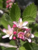
rosy-petalled cliffbush
View Report Copy Link Calflora eFlora CCH CalPhotos iNaturalist

© 2005 Steve Matson |
© 2010 James M. Andre |
© 2017 Neal Kramer |
Taxon Summary:
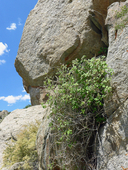
Jamesia americana var. rosea, commonly known as rosy-petalled cliffbush, is a perennial deciduous shrub in the Hydrangeaceae that is found in California and elsewhere. It occurs within Alpine boulder and rock field, Great Basin scrub, Pinyon and juniper woodland, and Subalpine coniferous forest, growing at elevations from 1980 to 3700 meters. Jamesia americana var. rosea is ranked 4.3, Plants of Limited Distribution, A Watch List; Not very threatened in California.|
Scientific Name: Jamesia americana T. & G. var. rosea C. Schneider |
||
|
Common Name: rosy-petalled cliffbush |
||
| Family: | Hydrangeaceae | |
| Element Code: | PDHDR02019 | |
| USDA Plants Symbol: | JAAMR | |
|
Synonyms/Other Names: |
||
| Name Status: |
JEF, FNA, POWO, IPNI, Tropicos |
|
| CA Rare Plant Rank: | 4.3 |
| Fed List: | None |
| State List: | None |
| Global Rank: | G5T4 |
|
State Rank: |
S4 |
| Other Status: | SB_CalBG/RSABG |
|
CRPR Changes: |
|
| Add Date: | 1994-01-01 |
| Date Edited: | 2025-10-29 |
| Lifeform: perennial deciduous shrub | ||||||||||||||
Blooming Period: May-Sep
|
||||||||||||||
|
Elevation:
1980 - 3700 meters 6495 - 12140 feet |
||||||||||||||
General Habitats:
|
||||||||||||||
| Microhabitat Details: | ||||||||||||||
Microhabitat:
|
||||||||||||||
| Threat List Total: | 0 | |
| Total EOs | % of EOs | |
| EOs with Threat Listed: | 0 | 0 % |
| THREAT LIST: | ||
|---|---|---|
| Total Occurrences: | 0 | ||||
| Element Occurrence Ranks: | |||||
|---|---|---|---|---|---|
| A | B | C | D | X | U |
| 0 | 0 | 0 | 0 | 0 | 0 |
| Occurrence Status: | |||||
|---|---|---|---|---|---|
| Historical >20 Years | 0 | ||||
| Recent <=20 Years | 0 | ||||
| Presence: | |||||
|---|---|---|---|---|---|
| Presumed Extant | 0 | ||||
| Possibly Extirpated | 0 | ||||
| Presumed Extirpated | 0 | ||||
| California Endemic: | |||||||||||||
| California Island: | |||||||||||||
|
States: Name (Code) California (CA), Nevada (NV) |
|||||||||||||
|
California Counties and Islands: Name (Code) Fresno (FRE), Inyo (INY), Mono (MNO), Tulare (TUL), Tuolumne (TUO) |
|||||||||||||
|
Quads: Name (Quad Code) Aberdeen (3611883), Bishop (3711834), Camp Nelson (3611825), Cerro Gordo Peak (3611757), Chagoopa Falls (3611844), Cirque Peak (3611842), Convict Lake (3711857), Coyote Flat (3711824), Dunderberg Peak (3811913), Haiwee Pass (3611821), Jail Canyon (3611722), Johnson Peak (3611843), Juniper Mtn. (3711862), Kearsarge Peak (3611873), Kern Lake (3611834), Lodgepole (3611856), Marion Peak (3611885), Mazourka Peak (3611881), Mineral King (3611845), Mount Tom (3711836), Mount Whitney (3611853), Mt. Abbot (3711847), Mt. Barcroft (3711852), Mt. Brewer (3611864), Mt. Clarence King (3611874), Mt. Darwin (3711826), Mt. Henry (3711827), Mt. Kaweah (3611854), Mt. Langley (3611852), Mt. Morgan (3711846), Mt. Pinchot (3611884), Mt. Thompson (3711825), New York Butte (3611768), North Palisade (3711815), Olancha (3611831), Sphinx Lakes (3611865), Split Mtn. (3711814), Telescope Peak (3611721), Templeton Mtn. (3611832), The Sphinx (3611875), Triple Divide Peak (3611855), Tungsten Hills (3711835), Waucoba Mtn. (3711811), Waucoba Spring (3711718), Wildrose Peak (3611731) |
|||||||||||||
Notes:
|
|||||||||||||
 Presumed Extant
Click on quad for name. Hold Shift Key to use mouse scroll wheel