Taxon Details
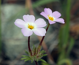
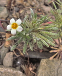
Leptosiphon latisectus
broad-lobed leptosiphon
View Report Copy Link Calflora eFlora CCH CalPhotos iNaturalist
© 2015 Steve Matson |
© 2016 John Doyen |

© 2012 Vernon Smith |
Taxon Summary:
Leptosiphon latisectus, commonly known as broad-lobed leptosiphon, is a annual herb in the Polemoniaceae that is found only in California. It occurs within Broadleafed upland forest, and Cismontane woodland, growing at elevations from 170 to 1500 meters. Leptosiphon latisectus is ranked 4.3, Plants of Limited Distribution, A Watch List; Not very threatened in California.|
Scientific Name: Leptosiphon latisectus (E.G. Buxton) J.M. Porter & L.A. Johnson |
||
|
Common Name: broad-lobed leptosiphon |
||
| Family: | Polemoniaceae | |
| Element Code: | PDPLM09150 | |
| USDA Plants Symbol: | LELA43 | |
|
Synonyms/Other Names: |
||
| Name Status: |
JEF, FNA, POWO, IPNI, Tropicos |
|
| CA Rare Plant Rank: | 4.3 |
| Fed List: | None |
| State List: | None |
| Global Rank: | G4 |
|
State Rank: |
S4 |
| Other Status: | |
|
CRPR Changes: |
|
| Add Date: | 2001-01-01 |
| Date Edited: | 2025-10-29 |
| Lifeform: annual herb | ||||||||||||||
Blooming Period: Apr-Jun
|
||||||||||||||
|
Elevation:
170 - 1500 meters 560 - 4920 feet |
||||||||||||||
General Habitats:
|
||||||||||||||
| Microhabitat Details: | ||||||||||||||
|
Microhabitat:
|
||||||||||||||
| Threat List Total: | 0 | |
| Total EOs | % of EOs | |
| EOs with Threat Listed: | 0 | 0 % |
| THREAT LIST: | ||
|---|---|---|
| Total Occurrences: | 0 | ||||
| Element Occurrence Ranks: | |||||
|---|---|---|---|---|---|
| A | B | C | D | X | U |
| 0 | 0 | 0 | 0 | 0 | 0 |
| Occurrence Status: | |||||
|---|---|---|---|---|---|
| Historical >20 Years | 0 | ||||
| Recent <=20 Years | 0 | ||||
| Presence: | |||||
|---|---|---|---|---|---|
| Presumed Extant | 0 | ||||
| Possibly Extirpated | 0 | ||||
| Presumed Extirpated | 0 | ||||
| California Endemic: | |||||||||||||
| California Island: | |||||||||||||
|
States: Name (Code) California (CA) |
|||||||||||||
|
California Counties and Islands: Name (Code) Colusa (COL), Del Norte (DNT), Humboldt (HUM), Lake (LAK), Marin (MRN), Mendocino (MEN), Monterey (MNT), Napa (NAP), San Benito (SBT), San Francisco (SFO), San Mateo (SMT), Shasta (SHA), Sonoma (SON), Tehama (TEH), Trinity (TRI), Yolo (YOL) |
|||||||||||||
|
Quads: Name (Quad Code) Aetna Springs (3812264), Bailey Ridge (3912324), Balls Ferry (4012242), Bartlett Mtn. (3912227), Bartlett Springs (3912226), Bell Springs (3912385), Blocksburg (4012336), Briceland (4012318), Brushy Mtn. (3912352), Burbeck (3912344), Cahto Peak (3912365), Calistoga (3812255), Childs Hill (4112461), Chiles Valley (3812253), Covelo East (3912372), Detert Reservoir (3812265), Dinsmore (4012345), Drakes Bay (3812218), Finley Butte (4012137), Fort Seward (4012326), Foster Mtn. (3912342), Garberville (4012317), Hall Ridge (3912276), Hames Valley (3512088), Hanland Peak (4012283), Harris (4012316), Honeydew (4012421), Jamison Ridge (3912362), Jericho Valley (3812274), Kenwood (3812245), Knoxville (3812273), Lake Pillsbury (3912248), Lakeport (3912218), Larabee Valley (4012346), Lassen Peak (4012145), Laughlin Range (3912333), Leesville (3912224), Lincoln Ridge (3912366), Longvale (3912354), Lucerne (3912217), Mark West Springs (3812256), Mendocino Pass (3912278), Middletown (3812275), Miranda (4012327), Montara Mountain (3712254), Monterey (3612158), Mount St. Helena (3812266), Natividad (3612165), Newhouse Ridge (3912371), Noble Butte (3912386), North Chalone Peak (3612142), Noyo Hill (3912346), O'Brien (4012273), Orrs Springs (3912323), Palo Alto (3712242), Palo Cedro (4012252), Plantation (3812353), Platina (4012238), Potter Valley (3912331), Red Bluff East (4012222), Redding (4012254), Riley Ridge (3912286), Rumsey (3812282), Ruth Reservoir (4012334), Rutherford (3812244), San Francisco North (3712274), San Francisco South (3712264), Sanhedrin Mtn. (3912351), Shasta Dam (4012264), St. Helena (3812254), St. John Mtn. (3912246), Tan Oak Park (3912375), Ukiah (3912322), Van Arsdale Reservoir (3912341), Wilbur Springs (3912214), Willits (3912343), Yountville (3812243), Zenia (4012324) |
|||||||||||||
Notes:
|
|||||||||||||
 Presumed Extant
Click on quad for name. Hold Shift Key to use mouse scroll wheel