Taxon Details
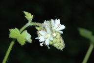
Sidalcea malachroides
maple-leaved checkerbloom
View Report Copy Link Calflora eFlora CCH CalPhotos iNaturalist
©2005 Dean Wm. Taylor |
Taxon Summary:
Sidalcea malachroides, commonly known as maple-leaved checkerbloom, is a perennial herb in the Malvaceae that is found in California and elsewhere. It occurs within Broadleafed upland forest, Coastal prairie, Coastal scrub, North Coast coniferous forest, and Riparian woodland, growing at elevations from 0 to 730 meters. Sidalcea malachroides is ranked 4.2, Plants of Limited Distribution, A Watch List; Moderately threatened in California.|
Scientific Name: Sidalcea malachroides (H. & A.) Gray |
||
|
Common Name: maple-leaved checkerbloom |
||
| Family: | Malvaceae | |
| Element Code: | PDMAL110E0 | |
| USDA Plants Symbol: | SIMA | |
|
Synonyms/Other Names: |
||
| Name Status: |
JEF, FNA, POWO, IPNI, Tropicos |
|
| CA Rare Plant Rank: | 4.2 |
| Fed List: | None |
| State List: | None |
| Global Rank: | G3 |
|
State Rank: |
S3 |
| Other Status: | |
|
CRPR Changes: changed from 1B to 4 on 2006-06-01 changed from 1B.2 to 4.2 on 2003-04-04 |
|
| Add Date: | 1994-01-01 |
| Date Edited: | 2025-10-29 |
| Lifeform: perennial herb | ||||||||||||||
Blooming Period: (Mar)Apr-Aug
|
||||||||||||||
|
Elevation:
0 - 730 meters 0 - 2395 feet |
||||||||||||||
General Habitats:
|
||||||||||||||
| Microhabitat Details: | ||||||||||||||
Microhabitat:
|
||||||||||||||
|
Notes: SCL Co. (427A) occurrence based on old specimen, needs confirmation. Threatened by logging and associated road usage, non-native plants, competition, low reproduction, road maintenance, and development. Endangered in OR. See University of Washington Publications in Biology 18:1-96 (1957) for taxonomic treatment. |
|
|
Threats: |
|
|
Taxonomy: |
|
| Threat List Total: | 13 | |
| Total EOs | % of EOs | |
| EOs with Threat Listed: | 109 | 80 % |
| THREAT LIST: | ||
|---|---|---|
| Logging | 93 | 68% |
| Road/trail construction/maint. | 83 | 61% |
| Non-native plant impacts | 15 | 11% |
| Other | 12 | 8% |
| Biocides | 8 | 5% |
| ORV activity | 4 | 2% |
| Grazing | 3 | 2% |
| Foot traffic/trampling | 2 | 1% |
| Altered flood/tidal/hydrologic regime | 1 | 0% |
| Development | 1 | 0% |
| Improper burning regime | 1 | 0% |
| Mining | 1 | 0% |
| Recreational use (non-ORV) | 1 | 0% |
| Total Occurrences: | 136 | ||||
| Element Occurrence Ranks: | |||||
|---|---|---|---|---|---|
| A | B | C | D | X | U |
| 4 | 15 | 41 | 43 | 2 | 31 |
| Occurrence Status: | |||||
|---|---|---|---|---|---|
| Historical >20 Years | 136 | ||||
| Recent <=20 Years | 0 | ||||
| Presence: | |||||
|---|---|---|---|---|---|
| Presumed Extant | 134 | ||||
| Possibly Extirpated | 2 | ||||
| Presumed Extirpated | 0 | ||||
| California Endemic: | |||||||||||||
| California Island: | |||||||||||||
|
States: Name (Code) California (CA), Oregon (OR)* |
|||||||||||||
|
California Counties and Islands: Name (Code) Del Norte (DNT), Humboldt (HUM), Mendocino (MEN), Monterey (MNT), Santa Clara (SCL), Santa Cruz (SCR), Sonoma (SON) |
|||||||||||||
|
Quads: Name (Quad Code) Ah Pah Ridge (4112348), Albion (3912327), Arcata North (4012481), Arcata South (4012471), Bear Harbor (3912388), Big Sur (3612137), Blue Lake (4012388), Bridgeville (4012347), Calaveras Reservoir (3712147), Cape Mendocino (4012444), Childs Hill (4112461), Cold Spring (3912315), Comptche (3912335), Crescent City (4112472), Dutchmans Knoll (3912356), Elk (3912326), Eureka (4012472), Eureka Hill (3812385), Fern Canyon (4112441), Ferndale (4012453), Fields Landing (4012462), Fort Bragg (3912347), Gualala (3812375), Hales Grove (3912377), High Divide (4112481), Hydesville (4012451), Iaqua Buttes (4012368), Inglenook (3912357), Korbel (4012378), Laurel (3712118), Lord-ellis Summit (4012387), Mallo Pass Creek (3912316), Maple Creek (4012377), Mathison Peak (3912336), McWhinney Creek (4012461), Mendocino (3912337), Monterey (3612158), Mt. Carmel (3612147), Myers Flat (4012337), Navarro (3912325), Noyo Hill (3912346), Owl Creek (4012358), Partington Ridge (3612126), Petrolia (4012433), Point Arena (3812386), Point Sur (3612138), Redcrest (4012348), Requa (4112451), Santa Cruz (3612281), Scotia (4012441), Shubrick Peak (4012422), Sister Rocks (4112462), Soberanes Point (3612148), Soquel (3612188), Stewarts Point (3812364), Taylor Peak (4012442), Weott (4012338), Westport (3912367) |
|||||||||||||
Notes:
|
|||||||||||||
 Presumed Extant
Click on quad for name. Hold Shift Key to use mouse scroll wheel