Taxon Details
Meesia triquetra
three-ranked hump moss
View Report Copy Link Calflora eFlora CCH CalPhotos iNaturalist
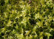
Steve Matson 2008 |
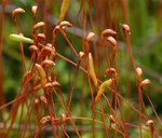
Steve Matson 2008 |
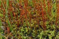
Steve Matson 2008 |
Taxon Summary:
Meesia triquetra, commonly known as three-ranked hump moss, is a moss in the Meesiaceae that is found in California and elsewhere. It occurs within Bogs and fens, Meadows and seeps, Subalpine coniferous forest, and Upper montane coniferous forest (mesic), growing at elevations from 1300 to 2953 meters. Meesia triquetra is ranked 4.2, Plants of Limited Distribution, A Watch List; Moderately threatened in California.|
Scientific Name: Meesia triquetra (Richt.) Angstr. |
||
|
Common Name: three-ranked hump moss |
||
| Family: | Meesiaceae | |
| Element Code: | NBMUS4L020 | |
| USDA Plants Symbol: | METR70 | |
|
Synonyms/Other Names: |
||
| Name Status: |
JEF, FNA, POWO, IPNI, Tropicos |
|
| CA Rare Plant Rank: | 4.2 |
| Fed List: | None |
| State List: | None |
| Global Rank: | G5 |
|
State Rank: |
S4 |
| Other Status: | |
|
CRPR Changes: changed from 2.2 to 4.2 on 2006-12-27 |
|
| Add Date: | 2001-01-01 |
| Date Edited: | 2025-10-29 |
| Lifeform: moss | ||||||||||||||
Blooming Period: Jul
|
||||||||||||||
|
Elevation:
1300 - 2953 meters 4265 - 9690 feet |
||||||||||||||
General Habitats:
|
||||||||||||||
| Microhabitat Details: soil | ||||||||||||||
|
Microhabitat:
|
||||||||||||||
| Threat List Total: | 5 | |
| Total EOs | % of EOs | |
| EOs with Threat Listed: | 8 | 42 % |
| THREAT LIST: | ||
|---|---|---|
| Grazing | 7 | 36% |
| Logging | 1 | 5% |
| ORV activity | 1 | 5% |
| Other | 1 | 5% |
| Foot traffic/trampling | 1 | 5% |
| Total Occurrences: | 19 | ||||
| Element Occurrence Ranks: | |||||
|---|---|---|---|---|---|
| A | B | C | D | X | U |
| 6 | 3 | 1 | 1 | 0 | 8 |
| Occurrence Status: | |||||
|---|---|---|---|---|---|
| Historical >20 Years | 19 | ||||
| Recent <=20 Years | 0 | ||||
| Presence: | |||||
|---|---|---|---|---|---|
| Presumed Extant | 19 | ||||
| Possibly Extirpated | 0 | ||||
| Presumed Extirpated | 0 | ||||
| California Endemic: | |||||||||||||
| California Island: | |||||||||||||
|
States: Name (Code) California (CA), Michigan (MI), Montana (MT), Nevada (NV), New York (NY), Oregon (OR), Vermont (VT), Washington (WA), Wisconsin (WI) |
|||||||||||||
|
California Counties and Islands: Name (Code) Alpine (ALP), Butte (BUT), El Dorado (ELD), Fresno (FRE), Humboldt (HUM), Lassen (LAS), Madera (MAD), Mariposa (MPA), Modoc (MOD), Nevada (NEV), Placer (PLA), Plumas (PLU), Riverside (RIV), Shasta (SHA), Sierra (SIE), Siskiyou (SIS), Tehama (TEH), Tulare (TUL) |
|||||||||||||
|
Quads: Name (Quad Code) Mt. Rose (3911938), Balloon Dome (3711942), Belden (4012113), Bogard Buttes (4012152), Bridgeville (4012347), Bucks Lake (3912182), Caples Lake (3812061), Cascadel Point (3711924), Childs Meadows (4012134), City of Mount Shasta (4112233), Clio (3912065), Dinkey Creek (3711912), Dogtooth Peak (3711921), Dogwood Peak (3912171), Echo Lake (3812071), Emerald Bay (3812081), English Mtn. (3912045), Freel Peak (3811978), Gold Lake (3912066), Graniteville (3912046), Grays Peak (4012146), Half Dome (3711965), Hobart Mills (3912042), Humboldt Peak (4012124), Humbug Valley (4012123), Independence Lake (3912043), Jess Valley (4112023), Jonesville (4012114), Kyburz (3812073), Larabee Valley (4012346), Lassen Peak (4012145), Little Shuteye Peak (3711944), Lodgepole (3611856), Meadow Valley (3912181), Medicine Lake (4112155), Meeks Bay (3912011), Mt. Givens (3711931), Mt. Harkness (4012143), Mt. Silliman (3611866), Musick Mtn. (3711923), Nelson Mtn. (3711911), Onion Butte (4012125), Panther Rock (4112272), Patterson Mtn. (3611981), Pondosa (4112126), Red Cinder (4012142), Rough Spur (3611888), Royal Gorge (3912024), San Jacinto Peak (3311676), Secret Spring Mtn. (4112282), Shuteye Peak (3711934), Sing Peak (3711954), Skunk Ridge (4112117), Sonora Pass (3811936), South Lake Tahoe (3811988), Sugar Hill (4112073), Tennant (4112158), White Chief Mtn. (3711945) |
|||||||||||||
Notes:
|
|||||||||||||
 Presumed Extant
Click on quad for name. Hold Shift Key to use mouse scroll wheel