Taxon Details
Erythranthe sierrae
Sierra Nevada monkeyflower
View Report Copy Link Calflora eFlora CCH CalPhotos iNaturalist
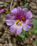
© 2014 Neal Kramer |

© 2014 Neal Kramer |

© 2014 Neal Kramer |
Taxon Summary:
Erythranthe sierrae, commonly known as Sierra Nevada monkeyflower, is a annual herb in the Phrymaceae that is found only in California. It occurs within Cismontane woodland (openings), Lower montane coniferous forest (openings), and Meadows and seeps (dry), growing at elevations from 185 to 2285 meters. Erythranthe sierrae is ranked 4.2, Plants of Limited Distribution, A Watch List; Moderately threatened in California.|
Scientific Name: Erythranthe sierrae N.S. Fraga |
||
|
Common Name: Sierra Nevada monkeyflower |
||
| Family: | Phrymaceae | |
| Element Code: | PDPHR01060 | |
| USDA Plants Symbol: | ||
|
Synonyms/Other Names: |
||
| Name Status: |
JEF, FNA, POWO, IPNI, Tropicos |
|
| CA Rare Plant Rank: | 4.2 |
| Fed List: | None |
| State List: | None |
| Global Rank: | G2 |
|
State Rank: |
S2 |
| Other Status: | SB_CalBG/RSABG |
|
CRPR Changes: added to 4.2 on 2013-10-02 |
|
| Add Date: | 2013-10-02 |
| Date Edited: | 2025-10-29 |
| Lifeform: annual herb | ||||||||||||||
Blooming Period: Mar-Jul
|
||||||||||||||
|
Elevation:
185 - 2285 meters 605 - 7495 feet |
||||||||||||||
General Habitats:
|
||||||||||||||
| Microhabitat Details: vernally wet depressions, swales | ||||||||||||||
Microhabitat:
|
||||||||||||||
|
Notes: Known only from southern Sierra Nevada. Several occurrences at lower elevations are possibly extirpated. Many occurrences historical; needs field surveys. Possibly threatened by development, grazing, vehicles, road construction and maintenance, recreational activities, and non-native plants. Previously identified as E. palmeri. Similar to E. gracilipes. Not in TJM 2. See Aliso 30(1):49-68 (2012) for original description. |
|
|
Threats: |
|
|
Taxonomy: |
|
| Threat List Total: | 0 | |
| Total EOs | % of EOs | |
| EOs with Threat Listed: | 0 | 0 % |
| THREAT LIST: | ||
|---|---|---|
| Total Occurrences: | 0 | ||||
| Element Occurrence Ranks: | |||||
|---|---|---|---|---|---|
| A | B | C | D | X | U |
| 0 | 0 | 0 | 0 | 0 | 0 |
| Occurrence Status: | |||||
|---|---|---|---|---|---|
| Historical >20 Years | 0 | ||||
| Recent <=20 Years | 0 | ||||
| Presence: | |||||
|---|---|---|---|---|---|
| Presumed Extant | 0 | ||||
| Possibly Extirpated | 0 | ||||
| Presumed Extirpated | 0 | ||||
| California Endemic: | |||||||||||||
| California Island: | |||||||||||||
|
States: Name (Code) California (CA) |
|||||||||||||
|
California Counties and Islands: Name (Code) Fresno (FRE), Kern (KRN), Tulare (TUL) |
|||||||||||||
|
Quads: Name (Quad Code) Alta Sierra (3511865), Auckland (3611951), Breckenridge Mtn. (3511845), Camp Wishon (3611826), Case Mountain (3611847), Claraville (3511843), Democrat Hot Springs (3511856), Durrwood Creek (3611814), Gibbon Peak (3511887), Glennville (3511866), Hockett Peak (3611824), Hume (3611878), Johnsondale (3511885), Keene (3511825), Kernville (3511874), Lake Isabella North (3511864), Lake Isabella South (3511854), Lamont Peak (3511871), Millerton Lake East (3711915), Mineral King (3611845), Miramonte (3611961), Mt. Adelaide (3511846), Pine Flat Dam (3611973)*, Pinyon Mtn. (3511842), Piute Peak (3511844), Posey (3511876), Sentinel Peak (3611815), Silver City (3611846), Springville (3611827), Tehachapi South (3511814), Trimmer (3611983), Tucker Mtn. (3611962), White River (3511877), Woodlake (3611941), Woody (3511867), Woolstalf Creek (3511853) |
|||||||||||||
Notes:
|
|||||||||||||
 Presumed Extant
Click on quad for name. Hold Shift Key to use mouse scroll wheel